Winter Weather Advisory

Let's Dance

>> Monday, January 1, 2018

The 1.2 inches Saturday means the official total did not get to 10 inches for the month.  Still we are above average.  The heaviest precip was south of the valley where some places hit three inches.  I can never pass up an opportunity to get out in the snow.  Maybe I should live in Erie.  I did learn something though.  If you ever have your phone outside on a hot day the phone will eventually shut off if the device gets too hot.  Well the same thing happens in the cold.  At the four mile turn around I took my phone out and the screen went black.

Speaking of Erie the snow continues to pile up.  When I last touched base on Erie they had received 53 inches of snow in 30 hours between Christmas and the following morning.  Since then they have managed to add another 29.3 inches.  That puts the total for the month at 121.3 inches.  Previously the most snow they ever had in one month was 66 inches.  Part of what makes these numbers so incredible is because of the banding, you do not have to go very far outside the city to see the numbers drop quickly.  The city just happened to be in the bullseye.  It will be interesting to see how much they end up getting for the season and how record breaking that could be.  Hitting 200 inches for a major city would be icing on the cake.

The big story this week besides the plunging temperatures will be the question of a coastal storm.  That question comes up a lot for our area during the winter.  This one is unique because it is basically coming up straight from the south.  The European model has continually trended slightly west albeit slightly.  If it continues that trend there might be a story.  As of this morning here are the predicted totals to give you an idea of how close this is to the coast.

Atlantic City = 8 inches
Allentown = 2 inches
New York = 2 inches
Harrisburg = 0 inches

Even New England misses the big event as it strengthens near Maine and unloads in Canada.

The GFS isn't buying into any of this as of now except that the storm strengthens once past the U.S.  At this point these models are having trouble agreeing on a few things.  One model has an all rain event for the second potential system next week and the other has all snow.  That's a pretty big difference.  So now we play the back and forth game until this system arrives Wednesday night.  All I can say at this point is the further east you are the better the chance you see accumulating snow.

I'll post a 2017 recap later today. 


Read more...

Single Digits

>> Thursday, December 28, 2017

Driving home through the little town of Bethlehem got we wondering.  The side streets were clearly and recently sprayed with salt in perfectly straight lines as if a snowstorm was coming.  Maybe something changed in the forecast.  Going back to last Friday I did mention there was a threat of a snowstorm this week.  I left it at that since there is never a reason to get ahead of yourself in winter.  I mainly use the idea of a storm to see how active the pattern could be.  Sure enough basically every storm scenario for the week fell apart except for the small disturbance Saturday.

There is a chance of some flurries tomorrow if that is important to you.  And when I say flurries I mean in very select areas and literally some flurries.  Then we move on to Saturday.  The system moving through is working with a lot of dry air and not much in terms of fuel.  It seems likely at this point it will snow during the day at least briefly.  In terms of what to expect I would put it this way.  Expect very light snow in all senses of the word light.  Expect at most an inch, likely less.  Do not expect issues.  The temperatures are clearly very cold right now.  This is the type of snow that will blow off the roads as soon as a car passes. 

It is certainly possible to get some higher totals in specific areas.  I'm not overly convinced that happens.  If Allentown can squeeze out 1.6 inches we will hit 10 for the month.  Not that interesting compared to other areas (looking at you Erie), but it has only happened once in the last seven winters.

Temps

Tough break for those coming home for the holidays that live in warmer areas.  This is an unusually cold week and will extend through the first week of January.  I don't have a large sample size, but the last three winters did not have any lows in the single digits during December.  We should get there at least twice.  Also going to be tough for anybody planning on spending 2017 into 2018 outdoors.  Both the low and high temp should be about 20 degrees below normal.  Keep that in mind if you are bar crawling or one of those weirdos that goes running in the middle of the night.  Locally Allentown is the only place I know of that has outdoor activities that lead up to midnight which includes fireworks.  Can't imagine it will be crowded downtown this year.

Upcoming

Going to continue to reiterate this every time for the rest of the winter... I hate to jump ahead.  One model is currently showing the potential for a storm next week.  When you talk storms with potential for large snow amounts word can spread fast online.  File it away and we will discuss later. 

Read more...

Crushing Records

>> Tuesday, December 26, 2017

Christmas of 2017 will officially go down as a white Christmas for Allentown and many other nearby locations.  Further south, not quite as lucky.  Further north and you were dealing with a blizzard.  Further northwest and, well, the lake effect machine can be a beast.  If you live along Lake Erie or Ontario you know what you are getting into.

These two lakes tend to draw the most discussion or interest and for good reason.  For starters there are many large cities impacted by lake events such as Cleveland (suburbs), Erie, Buffalo, Rochester and Syracuse.  All these cities are home to over 100,000 people.  Most of these areas average somewhere between 90 and 120 inches of snow a year which is far greater than any other major city.  Erie and Ontario can also be distinguished by the west to east length of the lake.  With cold westerly winds driving across that type of distance, bands can set up for hours or even days over the same locations.  None of this is news.  This is an every year event and in some cases an all winter event.  I tend to not spend much time on lake effect unless something unusual happens.  Something unusual happened.

Hello Erie.  While many spent time yesterday visiting with family, eating too much unhealthy food or trying to rest from a long day, people in the northwestern part of Pennsylvania received a very interesting gift.  Erie broke their one day snowfall record for any day by receiving 34 inches of snow on Christmas.  The city must have been extra nice this year because the snow didn't stop by midnight either.  Over the next six hours they added another 19 inches bringing the total snowfall in 30 hours to 53 inches.  Let me say that once more.  A city of 100,000 people received 53 inches of snow in 30 hours.  That's impressive.  I highlight the population because things like this happen in other areas that are home to hundreds maybe thousands of people.  This is a major city.  Wait there is more.

The city is currently under a Lake Effect Snow Warning through tomorrow afternoon for an additional 1 to 2 feet.  They might catch a break by Thursday before the snow will resume Friday and continue into the weekend.

By the end of the day Erie will either be just under or slightly over 100 inches of snow for the month.  The month.  That is their average for the year.  This isn't even normal for lake effect standards.   

I'll continue to monitor the situation in Erie.  I've included the link from the Weather Channel story which provides more info, video and pictures.  My favorite bit of info is the 13 day snow record was broken by an event that lasted 36 hours.

Take a look.

Read more...

The Eve

>> Saturday, December 23, 2017

7:00 A.M. Saturday morning update for Christmas Eve.  Both the European and short range models show a burst of heavier snow and both have slightly increased totals.


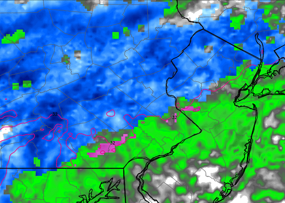
4:00 P.M. Update:  This will be the last run of the day unless I decide to stay up late.  No big changes.  Couple of notes.  The temperature should rise once the snow begins so there is certainly a chance to see a mix or even plain rain late Sunday.  Points to the south could struggle to get much of anything.  With temperatures at or above freezing I don't expect many issues on the roads.

Radar below is for 11:00 tomorrow night.  Totals stay similar.  Euro model is about the same.  GFS pushes the totals a bit further north with our area staying under an inch.


Read more...

  © Blogger template Webnolia by Ourblogtemplates.com 2009

Back to TOP