
Joplin: Day 2
>> Tuesday, May 24, 2011
The verdict is in without any surprise. Straight from the National Weather Service.
THE JOPLIN TORNADO HAS BEEN UPGRADED TO AN EF-5 TORNADO.

* DATE...22 MAY 2011
* MAXIMUM EF-SCALE RATING...EF-5
* ESTIMATED MAXIMUM WIND SPEED...IN EXCESS OF 200 MPH
* ESTIMATED PATH WIDTH...3/4 MILE
* FATALITIES...122 (Number as already increased since I started this)
* INJURIES...750
Everything other than the date above borders and crosses the line of stunning. 3/4 mile wide. That's unimaginable. Here is a comparison that might register a little more. 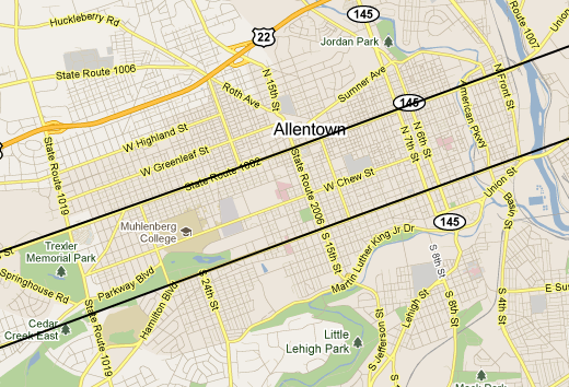
The black lines represent Tilghman and Hamilton streets. The distance between them is slightly less than 3/4 mile. That is how wide the tornado was going through a section ofa city of 50,000 people. While flipping through my numerous bookmarked sites and other weather related pages, I started reading the public information statement for the area and came across the following: THE TORNADO CONTINUED TO DESTROY OVER 100 HOMES BETWEEN 32ND AND 20TH STREETS. THREE STORY APARTMENT COMPLEXES HAD THE TOP TWO FLOORS REMOVED...OTHER TWO STORY COMPLEXES WERE PARTIALLY LEVELED. A BANK WAS TOTALLY DESTROYED WITH THE EXCEPTION OF THE VAULT.
And by the way, Joplin has received almost 4.5 inches of rain since the tornado and as of thispost the city is under a Tornado Watch, Flash Flood Watch and Flood Warning. ______________________________________________________________________ Tornadoes really started firing in Oklahoma and Kansas late this afternoon. In fact, I probablyspent nearly an hour watching TWC when I got home as they were viewing live footage of a monster tornado in central Oklahoma from a chase car. It was crazy. The storms are still firingand actually pushing towards Joplin. My watch box from yesterday might have been a bit far north.I will update as the night goes on depending on the situations.
When all the reports and tornadoes are confirmed tomorrow, I will have another post includingchecking in on Joplin once again as they prepare for more intense storms. 11 P.M. UPDATE****
No way I can cover everything that has gone on. Tornado I watched live when I got home is onvirtually every site now including the phone pole snapping over the chase car. Ballpark at Arlingtonhad to be evacuated due to large hail and tornado threat. Potential tornado missed Joplin, now thecity braces for a severe thunderstorm with winds upwards of 70 mph.

3 comments:
RD-So have scientists done any studies linking severe hurricane and tornadic weather to global warming? Just curious...
DJG
RD-I like your Allentown analogy...makes it more personal and relatable.
DJG
No matter what the topic, you could give scientific reasoning on both sides for why it is happening. At some point when things slow down and I get to finally recap winter, I will also touch on the beginning of hurricane season. Now there is where I'd be interested in seeing if there is a correlation, especially when storm come into the Gulf.
Post a Comment