Winter Weather Advisory

Single Digits

>> Thursday, December 28, 2017

Driving home through the little town of Bethlehem got we wondering.  The side streets were clearly and recently sprayed with salt in perfectly straight lines as if a snowstorm was coming.  Maybe something changed in the forecast.  Going back to last Friday I did mention there was a threat of a snowstorm this week.  I left it at that since there is never a reason to get ahead of yourself in winter.  I mainly use the idea of a storm to see how active the pattern could be.  Sure enough basically every storm scenario for the week fell apart except for the small disturbance Saturday.

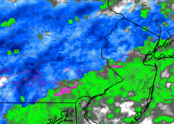
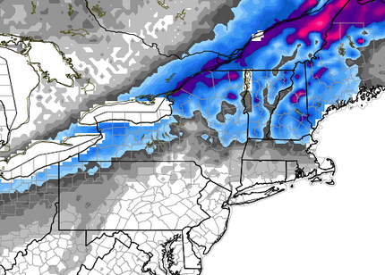
There is a chance of some flurries tomorrow if that is important to you.  And when I say flurries I mean in very select areas and literally some flurries.  Then we move on to Saturday.  The system moving through is working with a lot of dry air and not much in terms of fuel.  It seems likely at this point it will snow during the day at least briefly.  In terms of what to expect I would put it this way.  Expect very light snow in all senses of the word light.  Expect at most an inch, likely less.  Do not expect issues.  The temperatures are clearly very cold right now.  This is the type of snow that will blow off the roads as soon as a car passes. 

It is certainly possible to get some higher totals in specific areas.  I'm not overly convinced that happens.  If Allentown can squeeze out 1.6 inches we will hit 10 for the month.  Not that interesting compared to other areas (looking at you Erie), but it has only happened once in the last seven winters.

Temps

Tough break for those coming home for the holidays that live in warmer areas.  This is an unusually cold week and will extend through the first week of January.  I don't have a large sample size, but the last three winters did not have any lows in the single digits during December.  We should get there at least twice.  Also going to be tough for anybody planning on spending 2017 into 2018 outdoors.  Both the low and high temp should be about 20 degrees below normal.  Keep that in mind if you are bar crawling or one of those weirdos that goes running in the middle of the night.  Locally Allentown is the only place I know of that has outdoor activities that lead up to midnight which includes fireworks.  Can't imagine it will be crowded downtown this year.

Upcoming

Going to continue to reiterate this every time for the rest of the winter... I hate to jump ahead.  One model is currently showing the potential for a storm next week.  When you talk storms with potential for large snow amounts word can spread fast online.  File it away and we will discuss later. 

Read more...

Crushing Records

>> Tuesday, December 26, 2017

Christmas of 2017 will officially go down as a white Christmas for Allentown and many other nearby locations.  Further south, not quite as lucky.  Further north and you were dealing with a blizzard.  Further northwest and, well, the lake effect machine can be a beast.  If you live along Lake Erie or Ontario you know what you are getting into.

These two lakes tend to draw the most discussion or interest and for good reason.  For starters there are many large cities impacted by lake events such as Cleveland (suburbs), Erie, Buffalo, Rochester and Syracuse.  All these cities are home to over 100,000 people.  Most of these areas average somewhere between 90 and 120 inches of snow a year which is far greater than any other major city.  Erie and Ontario can also be distinguished by the west to east length of the lake.  With cold westerly winds driving across that type of distance, bands can set up for hours or even days over the same locations.  None of this is news.  This is an every year event and in some cases an all winter event.  I tend to not spend much time on lake effect unless something unusual happens.  Something unusual happened.

Hello Erie.  While many spent time yesterday visiting with family, eating too much unhealthy food or trying to rest from a long day, people in the northwestern part of Pennsylvania received a very interesting gift.  Erie broke their one day snowfall record for any day by receiving 34 inches of snow on Christmas.  The city must have been extra nice this year because the snow didn't stop by midnight either.  Over the next six hours they added another 19 inches bringing the total snowfall in 30 hours to 53 inches.  Let me say that once more.  A city of 100,000 people received 53 inches of snow in 30 hours.  That's impressive.  I highlight the population because things like this happen in other areas that are home to hundreds maybe thousands of people.  This is a major city.  Wait there is more.

The city is currently under a Lake Effect Snow Warning through tomorrow afternoon for an additional 1 to 2 feet.  They might catch a break by Thursday before the snow will resume Friday and continue into the weekend.

By the end of the day Erie will either be just under or slightly over 100 inches of snow for the month.  The month.  That is their average for the year.  This isn't even normal for lake effect standards.   

I'll continue to monitor the situation in Erie.  I've included the link from the Weather Channel story which provides more info, video and pictures.  My favorite bit of info is the 13 day snow record was broken by an event that lasted 36 hours.

Take a look.

Read more...

The Eve

>> Saturday, December 23, 2017

7:00 A.M. Saturday morning update for Christmas Eve.  Both the European and short range models show a burst of heavier snow and both have slightly increased totals.


4:00 P.M. Update:  This will be the last run of the day unless I decide to stay up late.  No big changes.  Couple of notes.  The temperature should rise once the snow begins so there is certainly a chance to see a mix or even plain rain late Sunday.  Points to the south could struggle to get much of anything.  With temperatures at or above freezing I don't expect many issues on the roads.

Radar below is for 11:00 tomorrow night.  Totals stay similar.  Euro model is about the same.  GFS pushes the totals a bit further north with our area staying under an inch.


Read more...

Snow or No

>> Friday, December 22, 2017

Even though I did not get a chance to post this week or last weekend after a fantastic Friday commute following an inch of snow and our third snow of the week, I should have at least taken screen images of the upcoming weather.

There is a reason you have to be patient with these storms.  A week and a half ago the idea of a Christmas snowstorm in our area was gaining steam.  A few days later and it looked like Christmas could again approach 60 degrees.  Then the models wavered.  Now it is pretty clear the cold air will win out and all across the area should anticipate the white stuff come Christmas morning.

Let's back track a bit before talking about the upcoming snow for our area.  At one time the indication was the storms track would favor the middle part of the country and cut north allowing for the warm flow to be well out ahead.  That clearly changed if you take a look at the current watches and warnings which start at the PA/NY border and continue north in every state.  Much of New York and New England will deal with anything from snow to ice and rain from now through Christmas.  So if you are traveling north good luck.

Tomorrow is a straight ahead rain event for the area with a bit of back end snow well to the west.  The map below will show snow totals through tomorrow.


Possible to see some wet flakes toward the end but all in all not a big snow event.

Then we get into Sunday.  A relatively weak system will pass by with a mix of rain and snow to the south and lighter snow to the north.  Once it passes us to the north it will intensify albeit slightly and enhance the chance of snow.  Radar image below.


More of a New England event but still snow for our area especially north and northeast.

Below are the predicted totals from the Weather Service as of tonight.


With the last few snow events coming as a bit of a surprise in the sense that we were not predicted to get much of anything, I think the map above is already accurate 48 hours in advance.  This event has been consistently showing up on each run with consistent totals.  It's really not worth guessing anymore so with an event like this I'm not going to predict a different total than above.

While snows like these can certainly be a pain for those out visiting family or going to church, the good news is the weekend will be warmer than it has been which should limit the amount of sticking on roads.  It will also greatly increase the chance that some will wake up to a white Christmas.


I'm never a fan of jumping too far ahead especially when there is already one event on the horizon, but in some cases we should at least acknowledge then let things play out.  There is what would be considered a major snowstorm showing up on the model runs for the end of next week.  The best thing to do at this time is enjoy the holiday and reevaluate early next week. 

Read more...

First Clipper

>> Thursday, December 14, 2017

With the weather being as cold as it has been over the past few days the snow that fell last night was light and fluffy.  Good news for the many morning commuters as roads were generally in good shape.  Snow totals tended to range higher as you went north.  I used the old eyeball test to note somewhere around three inches this morning yet I could see the top of the grass when I got to work.  In fact, as the sun came out today most of the snow where I work had melted.  When I took a pit stop at the Moravian Bookstore tonight, even the walkways were still completely covered.  No safe way to run tonight.


Here is the best snow total map I could find.

Light Blue = 1 inch (Reading)
Medium Blue = 2 inches (Allentown)
Blue = 3 inches (Northern Northampton County)
Dark Blue = 4 inches


Looking Ahead


We should remain quiet this weekend.  Should being the key word.  There is a system moving out to sea to our south which could give southern New Jersey an inch or two.  Flashback to last weekend when we thought we were not going to get much and ended up with the most snow.  Not likely in this instance but take notice.  Best chance of snow is south and east of Allentown.

The big question leading into next week will be how active is the pattern as we approach Christmas.  Not close enough to talk about yet but clearly a reason I am bringing this up now.

Random note:  The past three December's failed to hit once inch of snow.  We currently sit at 6.8 inches with half the month to go.  Average is about 5 inches.

Read more...

A Nice Surprise

>> Sunday, December 10, 2017

There would be no way of knowing that a heavier band of snow would form from an area that ran through central Berks and Lehigh counties, but that's what happened during the first snow event of the season yesterday.  Many locations across the area came in between 5 and 8 inches which also happen to be some of the highest for the storm in our region.

I'll get this out of the way now and address later if anything changes.  My one concern during snowstorms is getting an accurate measurement which is why I rely on official weather stations at the airport in Allentown or Philadelphia.  These are the totals that will be in the books for years to come.  I've often complained that the station at Reading seems completely inaccurate.  This then forces locals to report their own measurements.  Needless to say that can be complicated for some storms, however there are many people who do it the right way and I'm sure many others who do not.  I say this all because Allentown (as of now) officially reports 4.9 inches.  That seems questionable.  Here is why.

The airport is north of downtown and west of Bethlehem.  This area is where the heavier band was sitting.  When I cleaned my car off last night I had no doubt we were sitting at roughly six inches.  The group at EPAWA in South Allentown reported a final total of 6.1 inches which verifies my estimate.  Take a look at the reported totals for Lehigh County.


Regardless of social media or trained spotters the one total that makes the least sense is the one at the airport.  Areas north, south, west and east of the airport all reported between 6 and 7.5 inches.  My only conclusion is the total is wrong.  Unless something changes the official total will stay at 4.9 inches.

Good way to start off the season when you get more snow than expected.  Next opportunity which is looking pretty good at the moment is Monday afternoon into Tuesday.  As of now this looks to be a bigger event for areas to the north.  I could see a range of 1-2 inches in our area depending on where you are.

Now for some select pictures for the snowfall from December 9th taken during my run.


Read more...

First Taste

>> Friday, December 8, 2017

Before we get to the winter update let's tend to a little fall cleaning.

After a period of warmer than normal conditions November brought us back to reality.  The average daily temperature for the month is 42.7.  This November the average was 42.8.  I'd say that is pretty darn close.  I heard many people say the month was quite a shock to the system as we seemed to skip straight from summer to winter.  It sort of makes sense.  The average temperature in November was 17 degrees colder than October.  That doesn't happen too often in fall.

While parts of the month seemed dreary Allentown recorded just 1.14 inches of rain which could make November the driest month of the year.  No measurable snow was recorded though snowfall was seen.  That's about to change for December.

Last post I mentioned I might be going against the grain suggesting we get a higher than normal snow total this season.  Quite frankly I have not seen what other predictions have been, just taking a guess they are at or below normal.  Since we have not received any snow as of this writing I can make my guess.  With that said my prediction for Allentown is 38.3.


First of the Season


Nice to see everybody get involved early in the season.  When they are receiving accumulating snow in Houston, San Antonio and Brownsville, Texas you know it's going to be an interesting storm.  A few days ago we were in the clear.  Now the system seems to keep shifting further west.  It won't mean a lot of snow, but it does seem clear we will be getting some accumulation.  Could take some time to stick so let's see what happens.  I think right around two inches is reasonable.

Current map from NOAA.


Winter weather on a Saturday afternoon.  Think I'll be out for a jog with momentary stops for picture taking.  


8:30 MORNING UPDATE:  

Not snowing as of yet so time to get a quick update.  First, here are the watches and warnings.  I believe they changed the criteria for what constitutes advisories across the area, so if you are wondering why places like Allentown and Easton do not have an advisory this is likely the case.  I'll do some checking to make sure.


Last snow total map.  Mentioned last night it seemed to be shifting west and the new totals this morning from NOAA suggest the same thing.  Only Allentown jumped by two inches in both range numbers.  This could be an interesting area to watch as well as the areas further west in this coverage area.


Read more...

  © Blogger template Webnolia by Ourblogtemplates.com 2009

Back to TOP