
Snow or No
>> Friday, December 22, 2017
Even though I did not get a chance to post this week or last weekend after a fantastic Friday commute following an inch of snow and our third snow of the week, I should have at least taken screen images of the upcoming weather.
There is a reason you have to be patient with these storms. A week and a half ago the idea of a Christmas snowstorm in our area was gaining steam. A few days later and it looked like Christmas could again approach 60 degrees. Then the models wavered. Now it is pretty clear the cold air will win out and all across the area should anticipate the white stuff come Christmas morning.
Let's back track a bit before talking about the upcoming snow for our area. At one time the indication was the storms track would favor the middle part of the country and cut north allowing for the warm flow to be well out ahead. That clearly changed if you take a look at the current watches and warnings which start at the PA/NY border and continue north in every state. Much of New York and New England will deal with anything from snow to ice and rain from now through Christmas. So if you are traveling north good luck.
Tomorrow is a straight ahead rain event for the area with a bit of back end snow well to the west. The map below will show snow totals through tomorrow.
Possible to see some wet flakes toward the end but all in all not a big snow event.
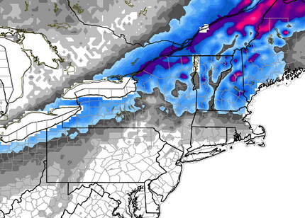
Then we get into Sunday. A relatively weak system will pass by with a mix of rain and snow to the south and lighter snow to the north. Once it passes us to the north it will intensify albeit slightly and enhance the chance of snow. Radar image below.

More of a New England event but still snow for our area especially north and northeast.
Below are the predicted totals from the Weather Service as of tonight.

With the last few snow events coming as a bit of a surprise in the sense that we were not predicted to get much of anything, I think the map above is already accurate 48 hours in advance. This event has been consistently showing up on each run with consistent totals. It's really not worth guessing anymore so with an event like this I'm not going to predict a different total than above.
While snows like these can certainly be a pain for those out visiting family or going to church, the good news is the weekend will be warmer than it has been which should limit the amount of sticking on roads. It will also greatly increase the chance that some will wake up to a white Christmas.
I'm never a fan of jumping too far ahead especially when there is already one event on the horizon, but in some cases we should at least acknowledge then let things play out. There is what would be considered a major snowstorm showing up on the model runs for the end of next week. The best thing to do at this time is enjoy the holiday and reevaluate early next week.

0 comments:
Post a Comment