Winter Weather Advisory

Tornado Hits Arkansas

>> Friday, December 31, 2010


Early this morning a tornado passed over the small town of Cincinnati, Arkansas in the northeastern part of the state, west of Fayetteville, near the Oklahoma border.  While I normally focus on the wintry side of things during this time of year, you can't forget that unstable air and differing temperatures still create battle zones in the south.  Unfortunately three people lost their lives this morning from the southern part of the storm that is hammering the upper mid-west.

Read more...

Blizzard In the Plains

>> Thursday, December 30, 2010

Less than a week after the blizzard along the eastern seaboard, the upper mid-west will join the party.  Portions of North Dakota, South Dakota and Minnesota will see strong winds and upwards of 20 inches of snow over the next two days.  The system will continue to push east into warmer weather, turning any frozen precipitation over to rain.


                                   Courtesy of accuweather, here is a look at the projected storm totals from the blizzard.

And as promised, here are some of the snowfall totals from complete random (or at least known) places before the storm moves into the central part of the country.

Flagstaff, AZ- 17.2
Spokane, WA- 9.0
Salt Lake City- 5.0

** Looking Ahead

Tomorrow I take a look at the conditions for hockey in Pittsburgh on Saturday and shift the focus back onto the local area.  Is it too early to use the snow word?

Read more...

Wicked West, Warmer East

>> Wednesday, December 29, 2010

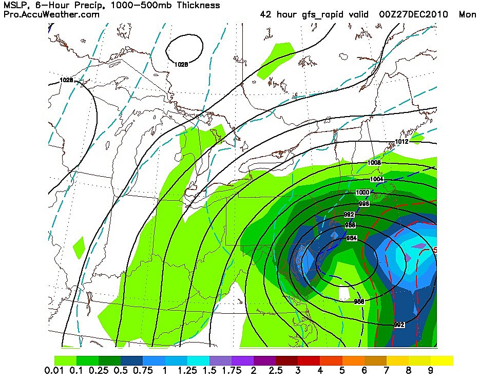
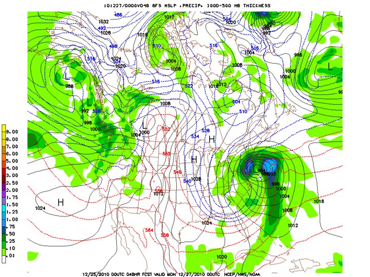
As the trough deepens in the west, causing another round of rain, cool temperatures and heavy snow, the jet stream will push north, bringing in some warmer temps for the eastern U.S.

First things first.  The east might have just taken the brunt of a winter storm, but the west is not backing down from the competition.  Currently counties in seven different states are under blizzard warnings, while the entire states of Utah, North Dakota and South Dakota have some type of winter weather warning.  


Notice the forecast above and check out the low temperatures of 28 and 29 degrees.  In the upper left corner you will notice what city those temperatures are for.  Needless to say, the west is going to be cold.

Last time a major system came barreling into the west, the northeast picked up 1-2 feet of snow.  Not this time.  Warmer weather will begin to settle in just in time for 2011 and could potentially cause the first ever problem for the NHL's annual outdoor game on New Year's Day in Pittsburgh.

Tomorrow I will take a look at the weather for game day and take a look at the snow totals from random places out west. 

Read more...

Dud For Local Area

>> Monday, December 27, 2010

As the monster storm cranked up the coast with Winter Storm Warnings as far west as the Appalachians, everybody prepared for what looked to be a sizable storm.  But by Sunday night with the winds cranking, the snow continued to fall only lightly.  By Monday morning the grass was still visible in many locations.  Allentown reported just under 3 inches while most locations in Berks received even less.

The rest of the week looks quiet before some wet weather moves in for the weekend with temperatures reaching the 40's.  I will take a look at the national weather as we see sunny skies for a couple days and keep updating the blog with more interactive videos.   

Read more...

2010 Post Christmas Storm

>> Sunday, December 26, 2010

Before I call it a night, I thought I'd post the latest storm forecast totals.  What an intriguing difference from one location to the next.  The "no" totals continue to creep west to include almost all of Berks county and now western Lehigh county as well.  But the light shades of pink have gotten larger to show near 20 inches across central New Jersey. 

If you look at the three county span in New Jersey starting in Hunterdon and heading east there is a forecasted difference of almost a foot of snow.  These types of storms always seem to amaze me.

I will take a look at the aftermath tomorrow evening and the extended outlook that includes warmer temperatures and none of the white stuff. 

Read more...

A Fine Line

Courtesy of NOAA.

Here are the latest forecast totals for both the Delaware and Lehigh Valley's.  One particular thing to notice with both this map and the radar, is the western side of this storm is just barely creeping past parts of Berks and Lancaster.  We have been saying from the get go the further west, the more snow will fall.  The storm needs to strengthen quickly and throw back moisture or some places will be left without much.

What can be seen is the nice yellow swath that extends from Philadelphia, Montgomery and Bucks, and includes place along the Delaware River that will see somewhere around ten inches.

Here where I am located, I think I'm on the outside of the bubble, watching this play out for everybody else.   

Read more...

A Christmas Wish

>> Saturday, December 25, 2010

For those of us that were wishing for a weekend storm, Santa pulled some strings and sure enough, here it comes.  After virtually every local forecaster called it a miss, it will ride the coast long enough to produce a good amount of snow for everybody.  Check the links to the right for updates.  I will try to be back on tonight.

Counties south and east of the Valley and all of NJ are already under a Winter Storm Watch.  By tonight, Allentown and Reading should be under some sort of advisory or watch.

                               Snowfall Sunday Afternoon

 Many thanks to the folks at accuweather and around the weather community

Read more...

>> Friday, December 24, 2010


Before I hit the sack for tonight, I thought I would share the latest model of the storm.  This model takes a look at the storm on Monday morning.  And folks, if this were to be true, you would see heavy bands of snow and strong winds.  I still believe that the storm has been pushed too far west all day today.  The EURO model, one that has been very accurate, will not come out until late tonight.  That model early this week had looked more like the one above but has been trending further east ever since.  Tomorrow morning could be the difference. 

Read more...

So Your Telling Me There's A Chance

If like me, you are hoping we get a decent snow fall from this store, you might be in for some good news.  It appears the models are slowly bringing this most illusive storm slightly back to the west.  What does it mean for our area.  Again, the further east you are in the valley and especially those in New Jersey have a better shot than say anybody from the Poconos on south along the mountains.  I wouldn't be surprised to see snow in most locations within eastern PA and virtually all of New Jersey.  Here is the kicker.  As of this posting, the models have still not been able to come to any sort of agreement because the storm has yet to develop. 


I have yet to see anybody willing to post snow totals and I think I will stay away from looking like a fool too, for now.  I hope to find some time tomorrow night to continue to update the blog, get everything organized and more visually pleasing and make my first snow fall map for the new blog.  Depending on the next 12-18 hours, this map might not even need to be drawn.

And maybe even more intriguing, the dividing line between measurable snow and nothing could fall within our area.  Should anything interesting happen within the next few hours, it will be posted.

Read more...

A First Step

It would only seem fitting to make my first post here at Lehigh Valley Weather about the back and forth model runs relating to the winter storm system that is capable of producing a decent snowfall depending on the exact tract. 

Quite frankly, I think the idea behind this blog came from the hours upon hours I have spent over the last few days watching countless models, videos and expert forecasters waver back and forth between the monster storm and the few flakes.  I want to know what is going to happen in my area, not in the Carolina's or along the New England coast.  As I continue to play around here on Christmas Eve, I hope to update what is happening and maybe put up a few images of what I hope becomes an active weather blog for folks in the southeastern Pennsylvania region.  

Read more...

  © Blogger template Webnolia by Ourblogtemplates.com 2009

Back to TOP