
Hype Train
>> Wednesday, February 15, 2012
I tried to pride myself on not jumping to conclusions this winter season since most storms take a long time to develop leaving predictions less than 24 hours away pointless. Too many times I've seen people dismiss a storm a few days out before we get 6-8 inches. It happened in October. And even more times do I see mets talking of the big one a few days in advance only to have the storm steer away from the coast or not even make it up. I get too excited only to be let down.
Well this season I didn't care what the models said five days in advance. I wasn't going to put much stock in it. At least not until everything started coming together. Only problem was that this season had nothing to get me excited about. A little snow here, warm temperatures for most of winter, little snow again. Not a winter to look back at and enjoy. That is why I am back with the hype. If the storms miss, who cares. I've already been less than thrilled with this season anyway.
That's why you will hear it first right here. We are getting a snowstorm this weekend.
That's right. I said it. I can't take it back now.

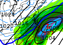
This is what the model shows currently for the weekend. That is beautiful. Low right off the coast. Strong winds from the northeast. Heavy snow in the interior. Now I will say this was not even close to what it looked like yesterday at the same time. But the closer we get to Sunday, the better the chances something happens. As of now this is looking really nice. I see the Weather Channel is still sitting on partly cloudy for Sunday. No surprise there. They won't even venture a guess until at least Friday.
So where is the problem? Slam dunk right? Not quite. Take a look.
This would be from the Canadian model. Notice the difference? Low moves off the coast further south and takes the moisture with it. We might get a passing flake out of this.

How about this model run from the Navy's prediction center. Shows that high pressure system dominating the northeast while the low goes out to sea. Certainly a possibility.

The dreaded euro model. One of the best advanced models out there. Bye bye low. Right in that same area as the Canadian model takes it.
What do we have going for us then? It's pretty simple. There should be cold air in place. I'm even a bit hesitant to say how cold though. The NAO is projected to go negative right around the 19th. That could do wonders for the track. A low is taking a U-shaped track down the Rockies and into the Gulf. Now will it curve back up? I say it will. Or perhaps my will, will will it up the coast. The models are not really agreeing.
I tried blowing up the GFS total snowfall accumulation predictions for the next 120 hours. Our area is anywhere from 4-8 inches but less than 30 miles in either direction and you could be looking at 0 or 10. Plus this is from the same model that has us getting plastered.

Before I go, I have to leave with this regardless of if something or nothing happens this weekend. A week ago I posted about what was on store for us ahead. I even posted a picture of what one model showed for right around the 19th or 20th. You can scroll down the page. I will wait. Back yet? Remember, the picture at the top is the "prediction" of one model for the 19th. Wouldn't this be something?

1 comments:
RD-If you are right about your prediction, I will bow to your amazing analytical and prgnosticator powers! You will become the meteorlogical Nostradamus.
However, my will will will the Low pressure south of our area and harmlessly out to sea over-willing your will. Checkmate!
Will be fun to see how this all turns out!
DJG
Post a Comment