
Here We Go - March Storm 2017
>> Saturday, March 11, 2017
Will this be one for the record books or simply a footnote for March storms? It's an interesting question that will be addressed over the next 48 hours. As an amateur meteorologist in all sense of the word, let me give you my two cents based on nothing more than instinct.
If you had asked me last weekend what the next week would have in store, I would have told you three things. There was a chance for moderate snow Thursday into Friday, another chance for a major storm over the weekend and perhaps a massive storm the next week. That was last weekend. That massive storm has stayed on the map every single day. Now the watches have started to pop up. It's not a slam dunk, but it's about as close as you can get.
Here is something I wouldn't have said over the past few days. Be careful of the extreme amounts at this stage. This has all the makings for a storm that brings a foot of snow. More than that could take the perfect set up. Here is what I see based on nothing else besides my own eye. I personally feel the storm is moving quickly. This isn't one to sit and spin like last year (which I still owe a post). When storms ride the coast they tend to get sucked into the jet unless there is some form of blocking which at this point I do not see. This could lead to a quick moving system. For our region that won't matter much because we have been and currently remain in the heaviest sector of snowfall. Even a slight shift west or east would not matter. We have consistently been in the heavy band of snow since the beginning of the week. No reason to think that changes much. Though I do think that could keep amounts lower than some anticipate.
Again we have to remember this is March. The system isn't working with a huge push of cold air. Temperatures at the peak of the storm will stay close to 32 degrees. This will likely lead to snow ratios around 10:1 as opposed to January or February which could be anywhere from 15 to 20 to one. Or the simple version is one inch of rain equals 10 inches of snow.
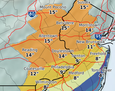
My original intention was to post all the maps and models from this evening. I'm not a big fan of the night time runs so I'm not going to post anything and wait until tomorrow. My early call would be the same as I have said all week, 12-16 inches for the region.
Here is one map. This is the current (Saturday) evening projected total from NOAA. Enjoy.

1 comments:
RD-Will be anxiously awaiting your Sunday and Monday posts!
DJG
Post a Comment