
Here Goes Nothing
>> Sunday, February 1, 2015
I'm now going to start throwing some different maps at you just for fun. We get to go on the journey together as I am posting these without seeing previous models. Here are the latest NAM runs for today (updates every six hours and just updated about two hours ago) for snowfall predictions. Mind you the snow here has begun as of 5:30.
Latest model shows 6 inches in Reading and 7 inches in Allentown.

Earlier today from around the lunchtime hour. Totals were a bit less.
Run from early this morning. Bigger from this morning but a more drastic cutoff.

The models always continue to adjust as the storm takes shape. With that so do the people predicting what we will get. I wanted to let my post from tomorrow stand, but I wouldn't be following my own advice that says predictions need to be given room for adjustments based off the latest information. My totals posted from tomorrow probably won't be accurate. They now seem high. However I will not change those. I'm just noting that they are less likely to be correct.
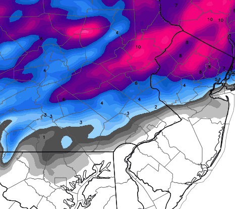
The National Weather Service made adjustments as well. This is their latest map. Keeps most of us in the 4-6.


The ice map would be a cause for concern if it was correct since our entire area is in a tenth to quarter inch. I'm not quite convinced this would happen and even if it did in some areas, it could melt before anybody knew of it. I changed my mind. I don't see ice as a concern.
GFS out of NYC.

If you're in fantasy weather model leagues it might be time to start playing the GFS. Seems like they got this storm right as well. Here is what they are predicting on the run that also just updated within the last hour. They even give it to you by the tenth.
Reading 3.1
Allentown 5.6
Looks like another near miss for us. Have to wonder if that is how the pattern is setting up this winter. There are certainly more events to watch for in the future. The predictions for tonight seem to continually be dropping. At this point seeing a few inches sounds like it might be a lot. All we can do now is watch it play out as all the models won't update again until later tonight.
I will be keeping this post open tonight. As far as I know nothing else is going on tonight so let's kick back and watch the show regardless of how unimpressive it might be.

1 comments:
RD-Let's hear it for the model that gives me the least amount of snow!!!
Thanks for all your hard work in collecting and posting the maps you use for your analysis. Hope you can keep adjusting the totals . . . DOWN!
DJG
Post a Comment