Winter Weather Advisory

Making History... Again

>> Sunday, March 12, 2017

Skipping the maps tonight.  I can't recall the models being as consistent with a storm as they have been with this one coming on Tuesday.  Everything continues to point to a major event anywhere between one to two feet.  I favor a number in the middle and will try and get a post with maps in tomorrow night.

It's hard to believe we could again be breaking records.  The storms once labeled once in a lifetime now need to be defined by the lifetime of what.  The Blizzard of 1996 and 1993 Storm of the Century were tales of legend.  Storms that were beyond what anybody could have imagined.  Both are the only storms to receive a category 5 rating on the NESIS scale.  No other storms even come that close.  Rightly so as these events had widespread ramifications and buried millions of people in feet of snow.  That 1996 storm produced the most snow Allentown had seen in recorded history at 25.9 inches.  Not sure anybody thought something like that could happen again.

Then came 2016.  20 years after the 1996 storm another storm approached in a winter that was seriously lacking in the snow department.  We weren't in line to get buried but things changed.  31.9 inches of snow later, a full 6 inches more that the previous record, a new single storm snowfall record was set. 

The 1993 storm was a monster though not as impressive locally as 1996.  17.6 inches fell during that storm that occurred on March 13th and 14th.  Let's read that again and take note of the dates.  Currently this storm is the second biggest to ever hit Allentown in the month of March.  24 years to the exact date and we are looking at another shot at history.

It would take 20.4 inches to break the record for biggest March snowfall.  It would also place in the top 5 all time biggest snowstorms.  The fact that two storms of this magnitude could occur in back to back seasons is hard to put into words.  Bizarre might be the easiest way to put it.

In doing some research and looking at my random database of weather I figured with the way the month is going this could end up becoming the snowiest March in recorded history.  It would take additional storms to get us there after this one so there is your hint for how the rest of the month pans out in case you are looking towards Spring.  Continuing with the research theme I determined that since 1980 Allentown has received more snow in March than in December.  So again, my apologies to March for thinking that winter was over.      

SUNDAY NIGHT SNOWFALL PROJECTIONS

Euro
Allentown:  22
Reading:  22
Philadelphia:  21

NAM
Allentown:  17
Reading:  18
Philadelphia:  12

Canadian
Allentown:  25
Reading: 23
Philadelphia: 24

NOAA has not changed much since yesterday.  They tend to change as they go and will likely update the map tomorrow morning.  GFS lost an hour of sleep last night and went to bed early.  I'm not posting the totals because they seem to be well off.
Read more...

Here We Go - March Storm 2017

>> Saturday, March 11, 2017

Will this be one for the record books or simply a footnote for March storms?  It's an interesting question that will be addressed over the next 48 hours.  As an amateur meteorologist in all sense of the word, let me give you my two cents based on nothing more than instinct.

If you had asked me last weekend what the next week would have in store, I would have told you three things.  There was a chance for moderate snow Thursday into Friday, another chance for a major storm over the weekend and perhaps a massive storm the next week.  That was last weekend.  That massive storm has stayed on the map every single day.  Now the watches have started to pop up.  It's not a slam dunk, but it's about as close as you can get.

Here is something I wouldn't have said over the past few days.  Be careful of the extreme amounts at this stage.  This has all the makings for a storm that brings a foot of snow.  More than that could take the perfect set up.  Here is what I see based on nothing else besides my own eye.  I personally feel the storm is moving quickly.  This isn't one to sit and spin like last year (which I still owe a post).  When storms ride the coast they tend to get sucked into the jet unless there is some form of blocking which at this point I do not see.  This could lead to a quick moving system.  For our region that won't matter much because we have been and currently remain in the heaviest sector of snowfall.  Even a slight shift west or east would not matter.  We have consistently been in the heavy band of snow since the beginning of the week.  No reason to think that changes much.  Though I do think that could keep amounts lower than some anticipate.

Again we have to remember this is March.  The system isn't working with a huge push of cold air.  Temperatures at the peak of the storm will stay close to 32 degrees.  This will likely lead to snow ratios around 10:1 as opposed to January or February which could be anywhere from 15 to 20 to one.  Or the simple version is one inch of rain equals 10 inches of snow.

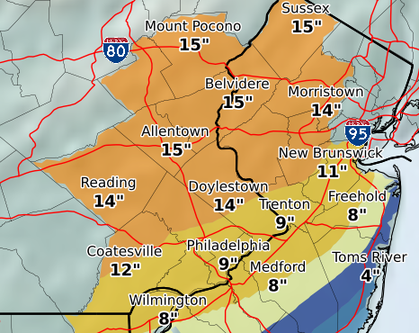
My original intention was to post all the maps and models from this evening.  I'm not a big fan of the night time runs so I'm not going to post anything and wait until tomorrow.  My early call would be the same as I have said all week, 12-16 inches for the region.

Here is one map.  This is the current (Saturday) evening projected total from NOAA.  Enjoy.


Read more...

Round 1 - March 10th

First round is in the books.  For the most part models and predictions were basically accurate.  It actually helped that the system did not move into the area until later than expected.  Temperatures made the difference as while many areas saw moments of heavy snow, it was basically melting as it was snowing or having trouble sticking at all.  That's where March does not favor winter lovers. 

The Totals


Allentown:  4.5  (Benefited from colder temps and a train of afternoon squalls)
Reading: 2.0  (Reporting is questionable at best, likely a bit higher) 
Philadelphia: 1.0  (Blame the warmer temps, snowed hard but didn't stick)


I've spoken before of the training of precipitation especially with rain in our area.  Every so often we get it with snow.  Yesterday was a good example as areas from Jim Thorpe to Allentown saw consistent rounds of snow squalls.  I knew this was the case leaving work and decided the best bet was taking the major roads home.  Probably a good call.  I caught the tail end of a heavy squall that caused one tractor trailer to jackknife into the grass.  After getting home the rounds continued into the evening every 30 minutes or so with quick bursts of heavy snow and wind.

I used this same bridge at 5:30.  Difference at that time was the sun was still out.


Read more...

Not Done Yet

>> Thursday, March 9, 2017

Forgive me for the lack of posts.  An average high of 50 degrees in February will do that to a winter enthusiast.  Thankfully March has stepped up to the plate looking to hit a long ball.

First a quick recap.  If you've been away or hibernating 2017 has been warm.  Oddly warm.  Six days over 60 and three days over 70.  In turn we have seen very little in the way of snowfall.  Officially Allentown has picked up 10 inches this year thanks to one moderate storm in February.  Places further south have done even worse.  If we received no more snow the rest of the year this would be the second lowest seasonal snowfall since 2000.

Speaking of that February storm.  Back in the summer I asked which was the only date that has seen measurable snowfall every year since 2014.  In a following post I gave the answer below:

TRIVIA ANSWER:  The only date that has seen snow each of the past three years is February 9th. 
Well it only snowed on one day in February.  That was the day we recorded 7.1 inches.  Want to take a guess at the date?


BRING ON MARCH

How quickly we forget about this month when it comes to winter.  I'm not sure why.  It's basically a better version of December.  Some of the best storms ever produced occured in this month.  In the winter of 14-15 March recorded more snow than any other month at 17.8 inches.  It also snowed the first day of the month and the last day.

If the pattern holds it's likely this year will also see March come out on top.  To the maps.

First system is overnight tonight into tomorrow.  Survey says according to the GFS.


4 inches for Reading.  3 inches for Philadelphia.  5 inches for Allentown.  Euro and NAM are very similar.  I'd take the under if I were placing bets.  The equivalent might be 3 to 5 inches but I don't think the measured amount will be equal.

That weekend system drops way south and actually fizzles out.  So that's a miss.  I'm fine with that when you look at the beginning of next week.  Classic nor'easter.


I'm well aware this is multiple days away but the models have shown a large snowstorm now sine last weekend.  So yeah, I'm posting the amounts.


Keep in mind this includes the snowfall from the event tomorrow.  So knock off 4 or 5 inches and you have a 12-18 inch storm.  The Euro also has this on the map as a widespread foot storm.  Just keep a watchful eye on this one. 

Thank you March.


Read more...

  © Blogger template Webnolia by Ourblogtemplates.com 2009

Back to TOP