Winter Weather Advisory

Rising Towards the Top

>> Tuesday, February 18, 2014

I'm not sure how this winter season will end up ranking compared to past winters.  I guess it could be a matter of opinion.  Numbers don't always give a clear indication.  What I have taken away from the season so far is the persistent nature of snowfalls and the steady stream of coldness.

We can start with the facts about this winter taken from recordings at Allentown Airport.  Including today the snowfall this season is at 66.7 inches.  That is 4th all time since recordings began in 1922.  Ahead of this season is 1993-94 (75.4), 1995-96 (71.4) and 1966-67 (67.2).  Considering the late February to early March outlook it would seem likely we at the very least move into second place if not first by the time winter is over.  Anything over a half inch will place the three snowiest years within the last 20 seasons.  Maybe that will put to bed the stories of the old timers telling us how high the snow was in their day.  The answer is apparently not as high as today.

This season we have had so far:

  • 22 days of measurable snowfall
  • 12 days of temperatures that fell to single digits
  • 6 different days the low fell to negative numbers
  • 31 days the high temperature failed to reach 32

Unfortunately I don't have the ability to compare this to anything historically.  However I could easily say this is unusually.  For instance, the average temperature in January was five degrees below normal.  The average temperature so far for February is seven degrees below normal.  It doesn't seem like a lot but it is.  December was right on average and November was three below normal. 

This type of weather starts lending itself to the cries of forecasters reassuring the upcoming warmup.  A normal winter has many ups and down.  Hitting 50 twice after all this cold must be like saying it will be 70 to many.  Here's the full story.  The following two weeks after this weekend will probably see temperature on average around 10 degrees below normal.  Ten degrees.  Two weeks.  Enjoy those 50's.

If we are going to break snowfall records this is going to be the year.  Everything added up to keep the cold air in place and the moisture flowing.  The next few weeks will not be nearly as active.  That's probably a good thing at this point.  It doesn't meant that there aren't chances for snow.

So by the time March ends (or April the way this is going) could we call this the worse winter in recorded history?  You could.  Will it be the snowiest?  I'm going to guess that it will.  Hitting that number one spot would make this the greatest winter ever.  Not the worst.  It's all how you look at it.


Read more...

Pre Valentine's Day Storm of 2014

>> Wednesday, February 12, 2014

Winter storms always have the possibility of changing right up until they hit.  Hell, they can change during the middle of the storm.  As I worked and meteorologists studied maps it is becoming more evident this has the makings of a big storm.

I didn't think I was going to get to make another post, but the National Weather Service has changed their idea today so I figured why can't I.  I was always told if you can't trust the accuracy of a government agency who can you trust.

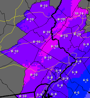
If you look at my post below you will see the totals they were going with right up through this afternoon.  Now it looks like this.


Widespread totals of double digits for Allentown and Reading as well as much of north western New Jersey and extending into the Poconos.  Philadelphia deals with some mixing.

Remember that darn North American model that wouldn't move the moisture as far west as others?  Here is what it picks up now.


The yellow to orange colors are at least 1.5 inches of rain.  What makes this one a little different is many areas in the heavy moisture will deal with mixing or a change to rain.  Our area is in one of the best for all heavy snow.  In this setup you are looking at upwards of 15 inches.  If you look around the NYC area you are probably getting closer to 20.

What makes this storm interesting to many is the size and area this covers.  You already have a major ice storm in the deep south.  Heavy snow between 10 and 20 inches will fall from Virginia to Maine.  It won't hit the big cities quite as hard as the interior cities but nonetheless this will make the history books simply because of the range of impacts.

Warm air might actually give us a little change over at some point.  Frankly that will just makes things worse.  It's already going to be a heavy snow.  We don't need to add to the weight with sleet or ice.  Let's stick with the snow and hope everything goes well.  Unless you have an important job that needs to keep you out tomorrow, enjoy the snowfall from inside.  I haven't really seen anybody predict less than 10 inches for our area.

We got lucky last time.  I'm not sure how lucky we will get this time.  Snowstorms are awesome until you lose power.  Assuming I am home and with power I will update when I'm not outside rolling around in the snow like a puppy.  Otherwise you will most likely find me outside enjoying every minute of the last major snowstorm of the season.  Who could ever get tired of this?

Read more...

Going to the Maps

>> Tuesday, February 11, 2014

The issue I was having that apparently many others are not is that even after waiting around those pesky North American models were not picking up the storm very well.  The heaviest moisture stayed closer to the coast.  Meanwhile the models like the Euro, Japan and Canadian keep pushing the storm even further west which would mean rain for the coast, a mix for I-95, and heavy snow for the suburbs.

Here we meet again waiting for the final run I will get to see before making my last post before the storm.  Actually I haven't even looked at it yet.  Let's see if anything has changed.  Alright let's try something.

In anticipation of seeing a change I grabbed the run from last night that kept me cautious about this storm.


The heaviest moisture is the orange while the lightest is the purple.  You can draw a line from the ocean to the mountains to go from heavy to light.  This is the one from last night.  Berks and Lehigh are in the lightest of blues.

Now 24 hours later this is what we see.


We can agree the heavier moisture is moving further inland.  With at least another 24 hours before the onset of the storm the question could be how much further does it move. 

The picture above would illustrate an 8-10 inch event in Allentown and Reading.  Snow would extend from Philadelphia and Trenton north and west with those areas pushing the foot plus range.  The problem is most are already throwing this one out (I'm not yet) because the others trend for big snowfalls to stay a bit further inland.

I'm not going to beat around the bush or use anymore ancient phrases.  I said last night I would go with what I thought and not worry about others.  Going into today I would have said most areas are looking at a foot as the low number for totals.  After seeing everything play out today I have less confidence in that idea.  Either way we are looking at a major storm. 

I pulled some storm totals from earlier this afternoon.  Some might have changed by now.

ABC says 10-14 inches from Lancaster to Reading to Allentown

CBS has a large area in 6-12 inches

Picture sums up this one from NBC

From the National Weather Service


EPAWA Group:  Red is 12-18 and Orange is 10-15


The fun part is I can't really say anybody is wrong.  The EPA guys as I like to call them tend to be aggressive with calls.  Sometimes it works and sometimes it doesn't.  They might be a tad on the high side.  I actually favor the NOAA call right now which is a little surprising for me because I generally haven't agreed with them this year.  Even though others call for a similar range I like my totals to be a little more accurate.  6-12 is too big of a range.  You could argue so is 12-18 but those are both already large totals.  What's the difference if you see 13 or 17.  12 is double the amount that 6 is.

Everything will start coming together tomorrow.  Once again power outages could be widespread with gusty winds and heavy snow.  By this time tomorrow night we should be well aware of what is coming.  I say should even though we probably won't.  These things always have a trick up their sleeves. 

Read more...

Here We Go

>> Monday, February 10, 2014

You know something is going on when winter storm watches are posted for Philadelphia days before the first flakes will fly.  Or when watches and warnings already extend from Georgia to Pennsylvania.  It usually means a couple things.  There is cold air to work with and a lot of moisture.

The reasoning the certainty of snow is already high is because all the big boy models have already agreed on a track except for the GPS which is notoriously slow to grasp the idea.  The agreement of models can certainly lead us towards the correct direction of a storm however with at least 48 hours of an open window for change I still can't go all in.

If we are going to get the big one this seems to be the candidate.  Even though a decent amount of snow has fallen, nobody in the northeast has seen that huge storm this year.  That could change.  In doing so, and with my belief in patterns, it could be the final KO punch of the season allowing us time to get up and move towards spring.

A lot of talk in the weather community for the northeast over the last week centered around the storms we already received and the one over the weekend that we did not.  This one didn't sneak up on anybody.  It's been on the model runs for just as long as the other storms, but it got buried behind the wave of storms.  It's finally pushed it's way to the front of the line and without us being able to see it from a distance, is becoming the biggest wave of them all.  Yes, I'm fully aware that my last comparison of winter storms was to trains but storms can be waves too.  Okay?

So here is the fun part about watching and waiting for models to come in.  They bounce around all over the place.  The shift, like many this season, was to push the storm further north and west then what was being picked up.  The model this afternoon did just exactly that.  Had I decided to show that one it would have looked impressive.  As I was writing this the run from tonight updated.  I figured it would push it even further north and west.  It instead took it south and east.  This is why I don't do a lot of commenting on storms too far in advance.  It could have been a bad run.  It could have been a sign that maybe this thing does stay closer to the coast and the overreaction has already begun.  I don't know.

I've been accurate enough this season that while I will read and take notice of what others are saying, I also will not put much stock into it.  They have had just as many missteps as anybody else.  It's weather.  What do you expect.  Meet me here again tomorrow night and we can pick up the conversation. 

Read more...

Ice Storm

>> Tuesday, February 4, 2014

This will be my last post ahead of the storm.  I'm going to keep this one short.

Normally I like to take a stab at what I think will happen during the duration of a storm.  This time I have to back off.  It is becoming more evident that warm air will set up in between layers of cold air to create a bigger icing event than I had thought.  I thought this because using my resources the temperatures never made it above 32.  They still don't.  But outside of other forecasts I have no way to tell that there is going to be a warm layer changing snow to rain and freezing it on contact.

This is what I can say.  After seeing the last run we are sitting in an area of almost 1.25 liquid inches of precipitation.  That's probably almost half an inch more than this past storm.  So whatever is falling is going to accumulate a lot.  If you notice our warning has dropped down to 1-2 inches of snow.  There is no mention of any change over to plain rain.  There is going to be an extended and heavy period of sleet and freezing rain.  It's enough to potentially cause serious problems.

Unfortunately this is exactly what we didn't want to see.  If you notice from the prior heavy, sticky snow the majority of trees and wires are already weighed down by multiple inches of snow.  The storm tomorrow alone could be enough to bring down trees.  Adding to what is already there is a recipe for trouble.  I expect to hear of many power outages tomorrow as well as downed trees.  Hell, nobody in PA has one yet but might be time to start throwing up some Freezing Rain Warnings.

Stay inside.  Be prepared for the possibility of no electric.  Or better yet, expect to lose power.


And a quick update on the weekend.  Regardless of what happens we are probably getting snow Sunday into Monday.  The difference will be a few inches or over a foot.  Latest run suggests the first option.


Read more...

Round 2

And a trend we did buck.

It would appear I was accurate that this past storm was more intense than most had thought it would be.  Allentown reported 9.3.  The highest in Berks I saw was 9.2.  It was an impressive storm for something I thought was completely downplayed by a lot of weather groups.  That is in the past.  We already have watches issued for the next storm.

This one is a bit tricky but I am going to ride my streak of success.  The trend since I've been watching this storm is to keep it running colder than previous runs.  What this means isn't exactly known as warmer air will end up overriding the cold air to form a layer of ice and sleet.  My feeling is this happens later during the storm and that most of what our area deals with is the snow.  It's not as heavy as this previous storm.  Precip is ranging from 3/4 of an inch to 1.2 inches. 

As many people are sick of winter, me not included, you have to really hope that this is a snow event.  Ice is something no vehicle can overcome.  By the way, with this last storm and clearly with another one and two looming I will take home the crown for being closest to the total seasonal snowfall for the Lehigh Valley.  I was the first to take a stab with 36-39 which ended up being the highest amount.  That total will be surpassed by the next storm.  My guess at this one is 5-8 inches with minimal ice.  I only say minimal because I don't think that there will be much moisture to deal with once that transition to ice takes place. 

This is one to follow closely.  The ranges are all over the place right now.  Most are in the range of 3-8 but the great people over at TWC have us in almost no snow.  Normally I'd say you never know, but there is nothing within the model ranges that suggest this area sees nothing.  Even if they are going with a gut feeling I think this is completely inaccurate.

THE WEEKEND

Regardless of all the other storms the constant talk seems to involve the 3rd train in line.  I can't say it isn't worth discussing.  If you compare the three they are almost moving in a sense from big to bigger to biggest.  However there are still many days between now and the weekend storm. 

The best thing to do is sit and wait.  We have another storm in 24 hours.  Then we can look at the weekend.  I'm in favor of a slower moving storm that takes it more into Monday.  The latest model not only had it being slower but also had it being far smaller and tighter of a storm.  Our area would be in line for the heaviest snow however with this trend I'm more cautious to call this an early week storm instead of a weekend storm. 

Read more...

Round 1

>> Sunday, February 2, 2014

Every single run of the short term model yesterday and today kept pushing this one north.  Somebody is going to hit 12 inches.  Either that or I'm completely inaccurate as the local weather service keeps us lower than what I would suggest as basically everybody is in the 4-6 inch range.


This is the finally run before I go to bed.  That's pretty impressive.  The good thing is it moves quickly and the worst conditions are after the morning drive and before the evening commute.  The bad news is this has the makings for a wide range of 8-12 inches of a heavier snow than we had been seeing.  Total rainfall amounts are coming in at 1 to almost 1.5 inches for much of the area especially south of Allentown and Reading.  This would equate to about 10-12 inches.  I can't imagine they don't change the snowfall amounts and increase the advisories unless I'm missing something.


The second storm already starts making the short term forecast map.  I'm a bit intrigued by this one as well as it seems to hold the wintry side of things longer than I think was originally anticipated.  That could be a good thing if we can avoid a lot of the ice and stick with mainly snow.  That one is far more complicated than the one tomorrow which is completely a snow event.

The weekend storm is still a complete unknown.  I can't figure out if there are two systems moving in together or if a transition occurs or if it is a single tracking storm moving right up the mountains.  Like I said in previous posts, it's fun to follow but not when there are two storms ahead of it.

Let's see what we get tomorrow.  We seem to be right on the cusp of many of these storms.  This one could buck that trend.


Read more...

Trainy Conditions

>> Saturday, February 1, 2014

The clipper pattern has transitioned to a southern train pattern.  The question for the next two weeks will be which tracks do the trains get on.

The 3 main tracks consist of the Great Lakes Line, Appalachian Regional and Coastal Express.  Each rail stops at the same locations but what they deliver differs.

The first train to kickoff the parade arrives this weekend with stops in Chicago, Detroit and Toronto.  Let's call this the Great Lakes Huron Line.  The train brings with it a batch of snow to the cities along its main route.  Areas to the east of the tracks or as it is more commonly referred to, the wrong side of the tracks, will miss the moisture and get temperature moderation delivered.

Snow Highlighted in Black Circle


Waiting at the platform to depart is train 2 on Monday.  Like with all east coast trains, scheduled deliveries and times are subject to change without warning.  This one looks to be headed in a slightly more west to east fashion in the Mid-Atlantic mainly south of the Mason Dixon line.  But could there be an unexpected stop in Philadelphia?  It's been a popular destination this winter.


The Global model continues to push the storm further north.  You can see here the heaviest precip stays south of Philadelphia.  In this shot this is closest the heaviest snow gets to our region.  However as mentioned, the trend from this model continues to push it further north which also brings it into colder air.


The North American short term run is starting to catch up to the other models.  Even last night it kept all the moisture south of Maryland.  Now we see a shift to heavy moisture up towards Philadelphia.  From a PA standpoint this is snow and probably snow for points north of Baltimore.  Talk about another fine gradient.  Might see nothing north of the Lehigh Valley and 6+ in Philadelphia. 

I can't stress enough how patterns shape weather.  I said it during the last storm to expect the heaviest snow to set up over Philadelphia and it did.  The winter ruts have Philly in the valley to keep the steady stream flowing like a river.  It would just make sense this one sets up similarly.  To my point see below.

Winter Snowfall for major east coast cities this season:

North of Philadelphia:
- Boston 33.5 inches
- New York 28.3 inches
- Hartford 23 inches

South of Philadelphia:
- Baltimore 12.7 inches
- Washington DC 8.1

PHILADELPHIA = 37.1 inches

Not difficult to figure out where the tracks are converging this year.

With some extra engines and a load of gear train 3 will be right on the heels of train 2.  The track seems to favor the Appalachian Regional though every area along all three tracks will see some type of garbage.  This locomotive brings snow, ice, rain, cold, warm, wind, sleet and just about everything else.


This image comes at the onset of the storm for us.  Notice the low over Ohio.  That would keep warmer air flowing north for us.  However at the beginning the storm as shown above would run into colder air first which could provide a mess.  The next few images show the low pressing east putting eastern PA in heavy precipitation before moving over NYC and then southern New England.  Lots of dynamics to influence conditions for many areas.

If you happen to miss these three trains have no fear.  There is another one coming up the tracks.


This is for next Sunday.  In the business we call this a nor'easter which I believe means giant winter storm.  No point in going into talking about this one when there are all these other trains to wait to pass by first.

The point is the next 7 days are going to be busy.  There is a very good likely hood that three storms will affect our area.  Perhaps all in major ways.

And that's how you make a weather post using train terminology.


Read more...

  © Blogger template Webnolia by Ourblogtemplates.com 2009

Back to TOP