
Going to the Maps
>> Tuesday, February 11, 2014
The issue I was having that apparently many others are not is that even after waiting around those pesky North American models were not picking up the storm very well. The heaviest moisture stayed closer to the coast. Meanwhile the models like the Euro, Japan and Canadian keep pushing the storm even further west which would mean rain for the coast, a mix for I-95, and heavy snow for the suburbs.
Here we meet again waiting for the final run I will get to see before making my last post before the storm. Actually I haven't even looked at it yet. Let's see if anything has changed. Alright let's try something.
In anticipation of seeing a change I grabbed the run from last night that kept me cautious about this storm.

The heaviest moisture is the orange while the lightest is the purple. You can draw a line from the ocean to the mountains to go from heavy to light. This is the one from last night. Berks and Lehigh are in the lightest of blues.
Now 24 hours later this is what we see.

We can agree the heavier moisture is moving further inland. With at least another 24 hours before the onset of the storm the question could be how much further does it move.
The picture above would illustrate an 8-10 inch event in Allentown and Reading. Snow would extend from Philadelphia and Trenton north and west with those areas pushing the foot plus range. The problem is most are already throwing this one out (I'm not yet) because the others trend for big snowfalls to stay a bit further inland.
I'm not going to beat around the bush or use anymore ancient phrases. I said last night I would go with what I thought and not worry about others. Going into today I would have said most areas are looking at a foot as the low number for totals. After seeing everything play out today I have less confidence in that idea. Either way we are looking at a major storm.
I pulled some storm totals from earlier this afternoon. Some might have changed by now.
 |
| ABC says 10-14 inches from Lancaster to Reading to Allentown |
 |
| CBS has a large area in 6-12 inches |
 |
| Picture sums up this one from NBC |
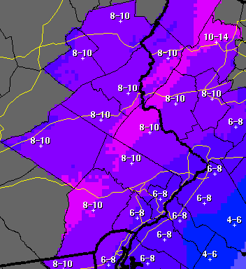 |
| From the National Weather Service |
 |
| EPAWA Group: Red is 12-18 and Orange is 10-15 |
The fun part is I can't really say anybody is wrong. The EPA guys as I like to call them tend to be aggressive with calls. Sometimes it works and sometimes it doesn't. They might be a tad on the high side. I actually favor the NOAA call right now which is a little surprising for me because I generally haven't agreed with them this year. Even though others call for a similar range I like my totals to be a little more accurate. 6-12 is too big of a range. You could argue so is 12-18 but those are both already large totals. What's the difference if you see 13 or 17. 12 is double the amount that 6 is.
Everything will start coming together tomorrow. Once again power outages could be widespread with gusty winds and heavy snow. By this time tomorrow night we should be well aware of what is coming. I say should even though we probably won't. These things always have a trick up their sleeves.

1 comments:
RD-good commentary and excellent graphics. If I had to distill this data I would sum it up like this . . . I'm going to have a LOT of snow to shovel and I better be ready for power outages! My back hurts already just thinking about it!
I'm glad for you . . . and people of your ilk . . . who love snow. But sorry . . . this just SUCKS!
DJg
Post a Comment