Winter Weather Advisory

Hitting The Bars

>> Monday, February 9, 2015

Really wanted to get to other things tonight aside from weather but things are getting comical now.  There is talk of where this winter will rank in the history of Boston.  The way things are going I wouldn't be stunned if it became the snowiest.  What's more impressive is most of it has come over the past three weeks.  Get ready for more.

I'm not breaking any rules because the things I am posting do not have much of an impact on us.  At least not right now.  In case you haven't heard it is going to get cold.  Of course you have because I said that a few times on here.  In fact I'm pretty sure you can enjoy the cold right into mid March.  Part of what makes this intriguing is it isn't just the northeast.  The cold extends right down to the coast of Florida.  It too doesn't make much of a move.

I'm not really sure what to tell the people of New England at this point.  Numerous places received more than two feet of snow today.  Which means there are places that have seen over 60 inches of snow in the past three storms.  Today was clearly not a nor'easter.  The next one, well...


Seriously?  That is nuts.  In the next image the millibars drop down to 970.  I'm sure I've said it before but the lower the drop the more intense a storm will become.  It might also help to know that pressure is listed in inches which I believe show up on local weather forecasts either on The Weather Channel or local news.  I will double check as soon as my local weather comes on.  Almost everything weather related is done in metric.  As is the above.  1013 millibars is standard.  980 equates to roughly a category one hurricane.  Let me just say that while the storm above is very strong I am putting this up here because the weather Boston has been getting lately is historically odd.  This would take it way over the top.  FYI - Late Thursday

Everything from here down is the second reason I decided to post.  Hold on.  TWC does indeed include the current pressure on the local forecast which is currently 29.99 or about normal.  Back to the show.  I'm going to pull back from the image above a bit so you can see the shape of the storm from afar.  Think of this as looking down from space.

   
This is one reason you don't want to be out on a boat during these storms.  You can see the tight formation close to the storm.  Once again these look very much like hurricanes with the circular formation, strong winds close to the center and heavy precip on the north and west sides.  Isobars remain close for hundreds of miles.  No doubt this is a big one.  Easily over a foot from Long Island to Maine.  Also known as the jackpot zone of 2014-15.

Now watch this.


What the hell?  This is the system trying to crank for the weekend.  Look at the size of this storm even compared to the other one.  You have snow sitting off the coast of Florida.  Heck there is a reading of 35 degrees in Florida with the 32 degree read line along the Florida-Georgia border.  As the storm continues towards Canada it drops to 951mb.  Not entirely uncommon when it gets sucked into the jet.  Does show the potential strength.  This is too far away.  I posted it now because if the trough digs in a bit more with no worry about cold air in place I'm afraid Boston could disappear from the map under the amount of snow they will see from the previous storm and this one.

LEHIGH VALLEY 

The maps above do not show either storm hitting us.  That doesn't mean we won't see anything.  The one on the weekend is too far out so I won't touch base on that one.  The system for Thursday falls right into the time frame when we can start to take a look at predictions.

Of course the model I wanted to use is currently updating so I will have to come back later to finish this post.  Stay tuned for some rudimentary figures.


GFS is not impressed with Thursday.  This map is starting to look common for our area.


Read more...

Head North

>> Thursday, February 5, 2015

I mentioned two things in my last post that I will bring up again because they are of importance to the discussion.

1.  Patterns - Cycles in weather are common.  They happen in winter, summer, in 5 year stretches, in two week stretches.  There are all sorts of different patterns.  That's why I target Boston metro as the area to continue to see the snowfall.

2.  Trust the models with temperatures.  Storms not so much.


There are reasons you never get too worried or excited about storms that are five days away.  There are reasons you don't blow things out of proportion when you know weather models will shift 4 times in one day during 4 runs.  I've been checking on this mess heading into early next week every morning and evening.  Each day it gets less and less impressive.  So much so you might as well wave goodbye.  There should be a rule that outside of 5 days you can only mention the potential of a storm.  In the 4 to 5 day period you can show maps.  3 days away and you can begin to make predictions.  I'm sure I've not always abided by this but I think for the most part I do.  From now on this is exactly the rule I will follow on here.  Luckily for me I haven't said much about this next system or posted any maps.  There is a reason for that. 


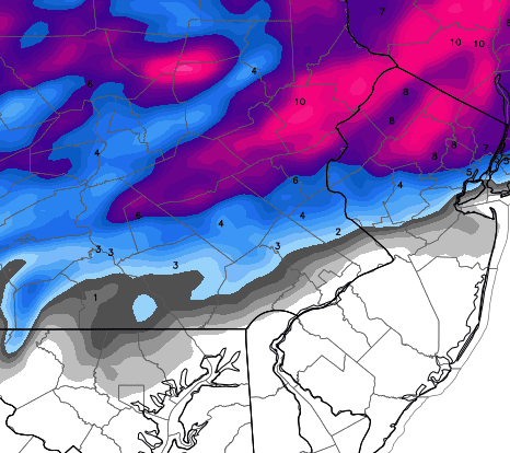
I'm going to show you the latest predictions from the GFS for total snowfall between now and Tuesday.


To be clear if you are having any trouble figuring it out this map shows Reading receiving somewhere around zero inches of snow.  This shift north has continued and continued and continued.  What makes weather and models such a pain in the ass to follow is most outlets went with the GFS which had Pennsylvania looking much like New York does now just a few days ago.  The GFS had been right twice before.  Look back at my last post and it says the Euro has the storm to the north with our area in 1-3 inches.  Well nobody sided with the Euro because as I also said, it's been getting destroyed by the GFS.  Now it seems like it has flipped again.

Who gets hit again with a potential one footer?  Boston.  Follow the pattern.  Of course this could all change again over the next few days though the chances of that are dwindling every hour.  We are still very close to the 32 degree line for the garbage that will come Sunday into Monday.  At this point I'd expect to see a bit of everything especially as you continue to moved north and northeast. 

Forgot during my last post to give an updated snow total.

Allentown - 23.1 inches

Read more...

Ride The Train

>> Tuesday, February 3, 2015

The track remains as storms continue to push through the region.  New England took another sizable hit with this last one as Boston ended up with over 16 inches of additional snow.  There are now many places that have seen between 35 and 45 inches of snow during the last two storms.

I realize I might have missed two nor'easters.  Whether either qualified is up for discussion.  The first was the weak clipper that passed through then developed off the coast of Maine.  Snowfall did exceed 10 inches though the wind speed is questionable.  For this reason I will leave it off the nor'easter naming list.  The one that passed through Sunday into Monday will more than likely need a name and recap as the only question was did it even become a nor'easter which I believe it did off of Massachusetts.  For now we will skip it because well, you know, I have a job and stuff that limits my time on here.

Back to that train.  Patterns people.  If I'm betting money my guess is Boston keeps finding a way to get more snowstorms.  Whether we remain on the edge is a matter of question.

For whatever reason the European model is really getting its ass kicked by the GFS.  I should probably also check the models before I start writing.  The European tried hard to get this storm on the 5th up the coast.  GFS said not happening.  After looking at the models the European has all but given up except for some snow way out on the cape.

Both agree on very light snow Thursday.  I mean very light.  A coating would be pushing it.  Then we get into another disagreement for Sunday and Monday.  The GFS is holding onto a snow event.  I'm not sure what else to call it because it's not a coastal storm.  In fact the majority of snow stays south of the New York border.  In the latest run a slow moving system ends up forming a decent low off the coast of North Carolina before pushing out to sea.  It's at least something to keep an eye on.  Pennsylvania is dotted with 6-10 inch totals.  The Euro keeps the system to the north and moves it quickly.  According to that model we would be in the 1-3 inch totals and New England would again come out with a decent storm.

As a side note the Euro has had an off-again on-again fascination with a pretty good storm for the south.  South being Alabama-Georgia-South Carolina.  I don't see anything of note yet but with the way this next month might play out who knows.

I tend to think models do better with temperature trends as opposed to figuring out where storms will form and go.

 
Here is the predicted temperature trend from now until March 20th.  I'll let you figure it out.  I'll also say this.  You can break this down by five day stretches.  There wasn't one that showed temperatures above average for any period.

Read more...

Here Goes Nothing

>> Sunday, February 1, 2015

I'm now going to start throwing some different maps at you just for fun.  We get to go on the journey together as I am posting these without seeing previous models.  Here are the latest NAM runs for today (updates every six hours and just updated about two hours ago) for snowfall predictions.  Mind you the snow here has begun as of 5:30.

Latest model shows 6 inches in Reading and 7 inches in Allentown.


Earlier today from around the lunchtime hour.  Totals were a bit less.


Run from early this morning.  Bigger from this morning but a more drastic cutoff.


The models always continue to adjust as the storm takes shape.  With that so do the people predicting what we will get.  I wanted to let my post from tomorrow stand, but I wouldn't be following my own advice that says predictions need to be given room for adjustments based off the latest information.  My totals posted from tomorrow probably won't be accurate.  They now seem high.  However I will not change those.  I'm just noting that they are less likely to be correct.

The National Weather Service made adjustments as well.  This is their latest map.  Keeps most of us in the 4-6.


The ice map would be a cause for concern if it was correct since our entire area is in a tenth to quarter inch.  I'm not quite convinced this would happen and even if it did in some areas, it could melt before anybody knew of it.  I changed my mind.  I don't see ice as a concern.


GFS out of NYC.


If you're in fantasy weather model leagues it might be time to start playing the GFS.  Seems like they got this storm right as well.  Here is what they are predicting on the run that also just updated within the last hour.  They even give it to you by the tenth.

Reading 3.1
Allentown 5.6

Looks like another near miss for us.  Have to wonder if that is how the pattern is setting up this winter.  There are certainly more events to watch for in the future.  The predictions for tonight seem to continually be dropping.  At this point seeing a few inches sounds like it might be a lot.  All we can do now is watch it play out as all the models won't update again until later tonight.

I will be keeping this post open tonight.  As far as I know nothing else is going on tonight so let's kick back and watch the show regardless of how unimpressive it might be.

Read more...

  © Blogger template Webnolia by Ourblogtemplates.com 2009

Back to TOP