Winter Weather Advisory

Storm Report

>> Monday, February 28, 2011

I wanted to at least get a follow-up post in tonight regarding my severe map yesterday.  I found the report from this morning that includes everything except any damaging weather occurring tonight.   

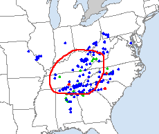
This is why the people who work at the NOAA went to school and get paid to do this.  I drew the red circle as more of a guide to show the target location (maps below).  Blue dots represent wind damage, green is hail damage and red is tornadoes.  It appears that three tornadoes were reported and from what I've read, the one in south central Tennessee included a fatality, though I haven't seen confirmation.  That's the unfortunately part of this but what researchers are also hoping to get more information to better predict and warn the public.


            Map posted yesterday from NOAA                                Storm Report today

As far as our weather is concerned, the GFS tonight pushed the heavier rain this weekend into later Sunday night into Monday.  I'll take that over a wash out of a weekend.  The storm on the 10th is still there but the question remains how cold will the air be.  It looks like highs for that time will be in the upper 30's.  And quite frankly I think going any further than that would be pointless right now with how many times things will change.  

My pro site days will be coming to an end soon.  I have enjoyed it and will miss a lot of the maps that are far more detailed than the freebies.  In fact, I think I will head over there right now and put in my cancellation.  It's back to the regular maps for me.   

Read more...

Wet Start

>> Sunday, February 27, 2011

The work week will start the same way it ended.  Rainy.  I don't have a lot of time for discussions, so I will shorten it down with quick explanations and maps.  Most of our area is under a Flood Watch.  The Poconos are under a Freezing Rain Advisory.  Winter is still hanging on in some places.  Off to the maps.


Here is the GFS model for tomorrow.  Notice the two lows, one in NY and the other in Kentucky.  It appears that both will cause two different pockets of rain.  The first, in blue under the 997 in NE PA shows the heavier showers.  Notice it appears to be north of most of our area.  I think this is fairly accurate in that the heavier precip falls to our north but still delivers a good 3/4 of an inch.


This would be the second wave in the afternoon that had been over Kentucky.  You can see the heavier swath of rain.  This would translate into more intense downpours, think almost like bands of rain instead of one big pocket like the earlier one.


 Again, as we push towards the seasonal transition period, we will see the threat of tornadoes increase.  With pockets of warm, moist air tomorrow, the red circled area shows the best chance of severe weather.  I will try to get a severe weather report tomorrow to see if this map was accurate for damaging winds, hail or tornadoes.


By Tuesday things will quiet down and should stay quiet for the remainder of the week with at least moderate temps for a day or two before they cool down again by the end of the week.  The weekend is not looking so good with overcast days and another decent rain event.


Here we have the model for next weekend, predominantly Sunday though rain would show up Saturday too.  Once again we see that dark blue over eastern PA and much of NJ indicating a heavy rainfall.  We even see a low forming off North Carolina almost like a winter storm.  Notice the line in this case would show a sweeping cold front.  Cold enough to change moisture over?  Can't tell yet but we really don't see that often.


I had made mention and showed a model image for a big storm around March 9th or 10th.  I also said it was extremely unlikely.  A mere couple of days later the storm is virtually not even on the map.  There is still something there in terms of precip but not anything worthy of posting on here.  Does it spell the end of winter?

Ha.  The simple answer to our frustrated friends... Nope.

Read more...

One of them Days

>> Thursday, February 24, 2011

This week will be going out with a bang.  There are currently 22 states that have at least one county under a winter storm warning including a line that stretches from central Kansas to Maine.  Snow levels in California are down to one thousand feet.  Seven states are under tornado watches, with spotty tornado warnings and flash flood warnings in and amongst this group.  But hey, it's a big country and you have to expect things like this.

Then there is Pennsylvania.  The seemingly small state compared to the rest of the country will see the ultimate wild weather.  Erie is under a winter storm warning for 7-10 inches of snow.  Pittsburgh is under a flood watch and flood advisory.  Bradford has a winter storm watch for at least 6 inches of a wintry mix.  Philadelphia is under a high wind warning and flood watch.  All in all the state has six different advisories at this time.  For comparison, Texas and California as of this writing combined have five. 

As far as our area is concerned, we are under the wind and flood advisories.  Tomorrow is going to be a far cry from last Friday.  Remember it?  It was sunny and around 70.  Ringing a bell?  Obviously tomorrow will be a bit different.  One to two inches of rain is likely with sustained winds at 30 mph with gusts over 50.  Thankfully the snow has melted and will not cause increased flooding.  If you miss the snow, don't worry.

Saturday night just might bring some of the white stuff back before it is washed away by another heavy rain maker Monday into Tuesday.  Things will quiet down by mid week but next weekend looks to be the next chance for another soaker that could dominate the whole weekend.  And you know what, the GFS has a massive storm on March 9th tracking up the coast that dare I say, would be a snowstorm.

  Here is the March 9th storm.  Remember dark blue line is the 32 degree line. 

I only post the image above to show that I'm not making this up.  Clearly this will change and if you are hoping for a storm, I'd be crossing those finger pretty tight for the next two weeks because this won't happen.  I personally just get excited easily.  

If you have a memory of the last month or two of the pattern where it seemed like we were getting some type of wintry weather every few days, that's what the next couple weeks are going to be like except with rain.  There are some hefty storms rolling through on the models that will keep things wet and windy.


Read more...

West Gets White

>> Tuesday, February 22, 2011

Want to get a quick post in.  It looked like most of the snow stayed south of the Lehigh Valley last night.  Philadelphia picked up six inches.  Here where I am saw maybe two.  One thing is for sure.  Light powdery snow and slightly wet roads has turned cars the whitest I've seen this year.  That will all change soon enough.

Winter keeps chugging along as Winter Storm Warnings are posted for Seattle and Portland for 3-5 inches of snow.  It's is not unusual for those towns to get snow in winter but a couple of inches does to them the same as southern cities. 

The next system for us comes into play Thursday night and Friday.  I've heard a lot of different forecasts.  None really calling for snow, but at least a few that have a whole mess of the mixed bag.  I personally don't think it is very likely that wintry weather dominates.  There will be enough warm air in place to keep things wet.  A brief start or end of a mix or snow is possible though.  Either way it will be something to watch as somebody will end up with a decent snowfall.

Really haven't learned much about the changes at Accuweather.  I have the pro up and running now for the latest models, but again, this is a one and done thing.  I'm never going to pay for weather information.  I finally saw this afternoon different outlets picking up the Bastardi story.  The Washington Post was actually the first one.  I've heard lots of rumors as to where he might be headed, but whatever happens, changes will be taking place. 

There will be lots to talk about as we head closer to spring.  As we stay in winter, the south gets warmer.  Unstable air produces bad results.  In a matter of speaking, we are approaching tornado season.

Read more...

Turn of Events

>> Monday, February 21, 2011

Obviously I'm a bit of a weather junkie.  And my favorite place to go is Accuweather whether it be their website, their professional site (which I signed up for until the beginning of March) or the many Facebook pages flooded by constant talk from other junkies like me.  Well their was some major news that dropped tonight that was certainly unexpected.

Senior long range expert, Joe Bastardi, who I'm sure I've mentioned on multiple occasions for his very accurate long term forecasting and his take on global climate is leaving after 32 years.  Their has to be something behind this that I guess I will learn about tomorrow.  He is the focus of the pro site, a service that has to be paid for but has more models than you could ever need.  It's absolutely insane.  I did the free month and will then drop it like a hot potato.  Henry Margusity, who I follow everyday in the winter because his focus is primarily the northeast will apparently be moving to a bigger role on the pro site.  In fact, the story broke on his Facebook fan page that I look at every night when I get home.

Again, I will have to check this out tomorrow but in the world of weather this is like Gretzky being moved.  Bastardi was the face of Accuweather.  I'm almost in shock.  Hopefully things get straightened out because that site is wonderful for stories, maps, video messages and is extremely user friendly.  The experts virtually talk specifically to their followers.  Henry has done live chats during storms on weekends from his house with his followers.  You can't find that stuff anywhere else.  


Enjoy the cold air tomorrow and any snow that falls.  The colder air isn't going anywhere like I mentioned and more snow is in the longer range forecast.  Updates on all of this tomorrow.

Read more...

Winter Returns

>> Sunday, February 20, 2011

Anybody remember the summer-like warmth of Friday?  A mere two days later winter watches and warnings are spread out all across the country. 

Heavy snow will hit the Twin Cities and move into Wisconsin and Michigan.  Snow will fall in northern Pennsylvania, much of New York and make a move to New England.  Another system will form giving the chance for snow to Philadelphia, Baltimore and Washington D.C.  Areas north and west of the big cities could see a bit of a mess to start with everything from sleet to snow to freezing rain.  And we've learned that it doesn't take much to cause a mess.  The morning we were issued a winter weather advisory for freezing rain turned out to be a much more hazardous day than when we had an ice storm warning.

Forget about the warm temperatures.  They won't be returning anytime soon.  And by any time soon, I'm thinking you won't see another even 50 degree day until mid-march or some time after the second week.  More wintry weather will return with mixes, rains and snows.  Just think of Friday as an early preview of what will eventually come.

As I post some entries, I am working on my first climate entry.  I'm taking my time and adding things here and there.  These won't be frequent posts because they are time consuming, as all post are.  If anything, I'll take it more in the direction of a group discussion whether it be from me, others, science articles or whatever. 

Read more...

Seasonal Battle

>> Friday, February 18, 2011

In one corner we have winter, in the other spring.  Assuming we are in a rectangular room there are two others corners, one which contained the office bug and the other myself.  They all collided in the middle this week. 

I fared pretty well.  The other three people around me missed a combined five days.  I averaged nine hour days all week.  I'm a firm believer in keeping it simple while fighting back.  The first day I didn't feel well, I drank tons of fluids like tea, water and Gatorade.  I also ran three miles.  I kept eating my normal meals but packed lots of nutrients into the early meals.  Kept the drinking going throughout the day and used medicine only when I felt I needed to.  Even when I got home I did something active.  A 30-minute brisk walk on a treadmill or a little roller hockey, anything to keep my body going.  If I wasn't feeling it, I called it a day and got as much sleep as I could.  Other people looked like they were hit by train, while I got clipped by the breeze.  It goes to show that a healthy lifestyle of eating well, drinking water and exercising (granted, I go well overboard compared to most) goes a long way during this time of year.

This all leads to enjoying the other battle during this often strange and intriguing time of year.  The highs in Allentown starting last Saturday went as follows, 38, 42, 52 then 35, 43, 60 to 66 today.  Remember I said enjoy Thursday and Friday and the snow would be gone by the weekend?  Even I didn't see it getting that warm.  And what follows record breaking temperatures, weekend highs around 40 with winds approaching 60 mph tomorrow.  Craziness.     

This transition from season to season reminds me of the fall to winter change except with more fireworks.  If you look west you will see the mountain locations getting pummeled.  Lake Tahoe, Flagstaff and the mountains of Utah and Colorado are expecting a foot while the Dakota's and Minneapolis braces for a early week storm.  And what about snow in our forecast?  It's hard to imagine going from 70 to snow a couple days later but that just might be the case.  In fact, looking at the long range, the beginning of March is looking pretty cool.  

Haven't been showing maps because of the site rules that I don't choose to break so I'm back to the public maps to show what Tuesday morning could look like and the possibility of snow.


Again, the dark blue line is the "rain/snow" line.  At this point the models actually have the storm passing to our south which is kind of funny since the system moving through later Sunday will pass us to the north giving much of New York state a chance of snow.  Meaning, there might be a middle ground (perhaps our area) that misses the snow both times.

We will see.  It's good to be back!

Read more...

It Was Cold

>> Saturday, February 12, 2011

I have a couple things to work out before I begin posting on the other pages.  I noticed as I was about to make a post in the climate section that, unless I'm not seeing it, you can't make regular posts like I can here on the main page.  Everything would just become one big section of writing and maps, and I clearly do not want that.  I will have to look into it or figure something else out.  Maybe a link from the climate page to the main page or something like that. 

___________________________________________________________

There is no doubt that January of 2011 will go down in many record books especially for the northeast.  Many places broke monthly snowfall records and temperatures were amongst the coldest seen in years. 

Here are some little facts to throw out as the winter season begins to close.  

  • 20.2 Inches- The combined totals for Huntsville, Alabama and Atlanta so far
  • 21.4 Inches- The combined totals for Baltimore and Washington D.C.
  • 57.7 Inches- Total snowfall for New York City
  • 58.6 Inches- The combined totals for Denver and Salt Lake City
The weather station in Nowata, Oklahoma on Thursday recorded a temperature of minus 31.  If confirmed, that would be the lowest temperature ever recorded in the state.  Don't feel too bad, their high this coming Thursday, just one week later is forecast to be 72.

______________________________________________________________

And of course we in the area have to battle some more chilly days before we get the warm up.  I have been saying and will continue to say, we will hit the 50's by Friday and the snow will be gone by the weekend.  Now this might not apply for every single location throughout the Valley, but for most of us, it will be the case.  Enjoy this coming Thursday and Friday while you can because the long range models show a return of cold air the following week.  In fact, the models show the chance of two systems moving in around the 21st and 22nd that would produce snow yet again.  That is for another discussion.

Starting Monday, this is your week.  No signs of rain or snow, temperatures at least in the more comfortable range.  Get outside if you can before winter returns for at least another week next weekend.

Read more...

Bye Bye Snow

>> Wednesday, February 9, 2011

It has been so long since I haven't had to cover some sort of storm I don't exactly know what to do with myself.  I figured I'd take a look at the long range forecast which should please many people around the area.

There are two basic things to look at from now until the end of next week.  The first one is temperatures will reach the 50's by February 18th.  Write it down because it will happen.  Secondly, most if not all of the snow will be melted by that weekend.  Kind of an amazing turn around isn't it?

The projected snowstorm that was going to come up the coast is instead hammering away at the southern tier of the country again.  Parts of Oklahoma and Arkansas had over 20 inches of snow.  There are currently winter storm warnings in most of Alabama, Mississippi and the Outer Banks of North Carolina.  I'm glad I'm keeping this blog so I can look back at it next winter to compare and not say, "we've never seen this before," because that's all I want to keep saying this year.  Anyway, that was the storm I was thinking would flip the pattern.  And even though it won't do anything for our area, it does look like it will cause that flip.

We will have to deal with cooler temperatures until around Sunday, when the 40's arrive and hold.  The other nice thing in the long range is that the models are not showing any kind of precipitation and when precip does move into our area, it will not be cold enough for anything but rain.  That is looking possible sometime around next Friday or that weekend.

I can't rule out a return of winter at some point towards the end of the month when the seasons begin to battle.  A major snowstorm is unlikely (I have to hope or I'll be eating those words) but light snow and ice will still be players.  I think anybody would agree that more winter weather this season is very likely being that it is still the 9th of February.  We will just be getting a much deserved break. 

While we get away from the snow and ice, I will be adding to my other sections on the blog or at least updating them.  After some thought , I decided to move forward and add a page at the top that will deal specifically with the global temperature debate.  It's a touchy subject, but it's also my blog to do as I please.  Any posts made about the subject will show up on that page only and all comments are welcomed regardless of opinion as long as they are in good taste.  I'm always up for a good conversation.

Read more...

A Funny Thing Happened on the Way to Sunday

>> Sunday, February 6, 2011

What a beautiful day for a run.  Temps in the mid 30's, very light wind and beautiful sunshine.  T-shirt weather for me, with running gloves and a winter cap mind you.  I decided to up my mileage to three today.  With a little help from map my run, I came up with just the route I wanted to take.  A little more than half way in I slowly came up into a new development.  As I continued my track I was caught by the sight.  Ahead of me was a shallow view of the valley floor at its lowest.  The sun glistened off the snow with views of rolling hills in the background.  And all I could think was what a beautiful day for a run. 

The day might not have been as nice for snow lovers.  Yesterday some models were running the late week storm up the coast while others had it going out to sea.  I parked myself at the computer after the midday models came out.  I went through five different ones including the two biggies, the GFS and Euro.  Both out to sea.  I went to others and all out to sea.  This is when the locals come on TV and tell you the models are coming into agreement.  Anything can happen but we went from looking like a potential big storm to potentially nothing.

All the models did agree on the incoming system tomorrow night into Tuesday.  It still looks to me that snow would be the main factor, however it appears that timing will play an important factor with temps rising on Monday.  A few inches (2-3) are possible.  I still want to check the later model runs to see if anything changes.  I will update that after they come out and maybe take a look at the long range forecast. 

In case you missed it, I will say it again.  No maps will be shown of the model predictions, only the public ones will be posted.

__________________________________________________________

8:00 P.M. Update on Thursday-Friday system


As the beloved Harry Kalas would say, Watch this baby outta here!  Good golly, there is even high pressure located over SE PA now.  

Read more...

End of Winter?

>> Saturday, February 5, 2011

Odd thing to say on a morning that saw most streets become skating rinks isn't it?  I heeded my own advice and postponed my normal Saturday morning activities until around lunch time when roads cleared and temperatures got just above freezing.  If you were out earlier, it wasn't too pretty. 

However, I am talking about the Friday storm that is blossoming on the models.  There is a generally consensus amongst meteorologists that a winter pattern will break with one, late, major storm.  This potential end of the week storm might just be that one.

There is another week of winter weather before temperatures look like they might get into the 50's by next week.  I think that would be a welcomed feel for just about everybody.  And with winter appearing to be headed for the door, I will be diving into this last month head first with nothing left to lose.  I'm talking about looking at all the models including the very elusive Euro, North American including Canadian and the rest of the world.  If winter is going out, I'm going to make the most of it. 

The first system is set to move in Monday night or Tuesday morning.  In looking around at other forecasts it seems like there is a call for a start as rain or rain/snow mix.  My personal thinking is it is going to be all snow  throughout the Valley.  The heavier snow, if you want to call it that, is lining up along the interior mountains.  I'd basically expect a couple of inches to fall.

The Thursday-Friday storm is really the one on the radar of anybody following weather this week.  It has a potential to be a big storm that delivers snow to a healthy portion of the east coast.  Cold air will be in place so that won't be a problem.  The only thing now will be to watch the dancing of all the models.  The GFS does its same thing that it has done with virtually every single storm this year and that is take it out to sea.  Or in other words, it brings the storm through the south, turns it north over the Carolina's and then has it exit into the Atlantic.  The Euro brings the storm up the coast bringing our area snow but keeps the heaviest precipitation off the southern coast of New Jersey.  This is based off the latest runs from tonight.  Generally this season, the Euro has been more accurate further out and the GFS slowly trends the storm north and west.

What happens will only be determined in the upcoming days.  Regardless, snow will be in the forecast for at least one more week.

_________________________________________________________________ 

For this last month of winter I will be using a professional site with more models and diagrams than I could possibly ever go through.  Out of respect for their privacy rules, I will not be posting any maps or models from their site.  I will be posting maps that I have previously been using.  This week should test my ability to describe things that others will not be able to see in a way that is understandable.  I'm ready for the challenge.  Bring on one more storm!

Read more...

Wild Week Gets Wilder

>> Thursday, February 3, 2011

What do Brownsville, South Padre Island, Houston, Galveston and Baton Rouge all have in common?  You could probably think of a dozen answers before coming up with the one I am looking for.  They are all currently under Winter Storm Warnings. 

Just when you think you have seen just about everything this winter has to offer, you get to see something as rare as this.  This is almost becoming unreal.  All those pink shades are the warnings in every county along the Gulf in Texas including the southern most point.  Wow.


_______________________________________________________________________

Ice, snow, wind, blizzard conditions, temps hitting 30 below, wind chills near 50 below, businesses closed around Dallas during Super Bowl week, a storm that took up half the country, Chicago's snowiest day in February, a highway shut down with cars still on it.  Does anybody even remember there are states west of the Rockies?  And where this weather goes, so goes Jim Cantore.  I don't think anybody does it better live.


Want to know what else is interesting?  We always hear about the hardy folks in the mid-west who deal with sub arctic temperatures, continuous snow storms and endless winters.  Chicago is named the Windy City for goodness sake, though it has nothing to do with weather.  Yet this past storm that knocked the Chicago area on their butts was only the 3rd time since 1886 that the city picked up over 20 inches of snow.  In fact, it is only the 7th time they have received over 15 inches in one storm in the same time frame.  In comparison, New York City has seen over 19 inches in a single storm three times in a little over one year.  That's all I'm going to say about that.  It does beg to ask if there is a shift in the weather pattern.  Too early to tell now.
_______________________________________________________________________

I am aware that there is a storm coming in for Friday into Saturday.  Quite frankly I'm not sold on it being any more than a nuisance.  I can see snow at the start and even at the end.  A mix is possible too, but the models have consistently shown temperatures right at or slightly above freezing for the majority of the storm.  Like everybody knows, things can change.  Unless you are planning on being out at 6 in the morning on Saturday, things should be fine.  It's the weekend.  Stay in and relax for a little and go out in the afternoon.  Besides, there are more chances for snow next week including possibly a major storm.

Read more...

Youthful Resurgence

>> Wednesday, February 2, 2011

I realized something this morning when I woke up.  I still get that simple, wonderful, childlike excitement every time a winter storm approaches.

Like a brass young teen avoiding an assignment, confident that their butt will be planted firmly on the couch the next day, I did not even bother making a lunch last night.  I parked myself in front of the computer scanning the latest radar, finding the newest maps and occasionally (alright, every 10 minutes) glancing out the window.  By the time the precipitation started, my eyes could barely keep focused from a long day of work and hours of looking at weather maps.

As if the anticipation were bouncing around in my head all night, I awoke at 4:02 this morning.  Without missing a beat like a child on Christmas morning, I reached for the curtain to see what Mother Nature had brought me.  Eyes glazed, I pulled on the shade.  Within seconds I knew it was not was I had been looking for.  The ice was not thick.  It didn't even appear to be doing anything.  My morning stupor vanishing, I quickly turned on the computer next to my bed and headed straight for the radar.  Precipitation spotty.  Appears to be breaking up on the back end.  I had made the classic pre-storm faux pas: assuming it is going to be worse than it actually is.  All I could do was go back to sleep and reevaluate things later.

I'm the first to say I enjoy winter.  That part of my youth has never changed and I don't think ever will.  I don't mind the cold, shoveling, scraping windows, snow or anything else associated with my favorite season.  In fact, I haven't missed a Saturday or Sunday run in months.  And that has included runs in snow three times, high wind and temperatures in the teens.  However, there has been one thing I've taken much more of a notice to then when I was younger.

From the time you hit first grade until the time you leave education behind, winter weather always breeds the same familiar pattern.  Wake up.  Look outside.  Turn on the local TV station and hope to see your school scrolling across the bottom.  Closed is preferable, but a delay will work too.  God forbid your school isn't on the list and the moans and groans, complaints and disbelief will sure follow.  Only logical step now is to wait for the entire list to pass again to hope your school was added or was somehow missed by eagle eyes the first time.  At that age you become oblivious to the world that doesn't involve you.  Most of society doesn't work on delays.  My office won't show up on any lists.  When I head out at 5:30 a.m. to start digging myself out, there are the same three or four other people already doing the same.

I say that today after seeing yet again 600+ closures or delays on the local news website.  Schools and Universities closed in some cases the night before.  Meanwhile, anybody else willing (and frankly by 9 the roads were perfectly fine) is out tackling the ice and arriving to work on time.  I say this after Kutztown University opened at 9:30 yesterday morning after that whopping 1.5 inches of snow/sleet to only close at noon the same day 12 hours before the next storm would arrive.  Meanwhile I'm at work at 6:30 a.m. without any issues.  I say this after seeing countless parents leave early during days where roads are clear to pick children up from a daycare closing early.  I understand the need for the safety of children in conditions less than favorable, and I'm sure complaints flood the lines when school in not closed or delayed.  But when given that option, regardless of whether you are 8, 14 or 20 and in college, you never think about the countless number of others who in some cases have no choice but to go.  And when you are sitting in classes during the last week in June, somehow that excitement for a snow day is all but a very very distant memory.

_______________________________________________________________

I'm not touching the Friday night into Saturday storm.  We all could use a little break.  I did however want to share an article to fill the weather void from Accuweather that can be read here.  I must caution, if you are ready to never hear anything about winter again, you might want to avoid this until a later date.

The article gives a little summary of what Joe Bastardi, Accuweather's chief long-range forecaster, sees in his crystal ball following this atypical La Nina winter season.  I share this because from what I've seen and read by Bastardi relating to long term weather, he tends to be very accurate.  I would still take this with a grain of salt simply because forecasters base predictions primarily off of events from the past.  For example, 9 out of 10 La Nina's seasons produce mild air and less snow.  They look at ocean temps, see it is a La Nina year and say, 9 out of 10 tend to be warm and dry, so that's the call.  This turns out to be that one year, like the one we are in now, that is the odd ball.  So basing trends off the irregular season leads me to start guessing.

Bastardi did predict a big warm up towards the end of the month with temps approaching the 60's.  Let's see how he does on that one before we look years down the line. 

Read more...

It's Gonna Get Ugly

>> Tuesday, February 1, 2011

Not only will things turn ugly outside but dangerous as well.  With predictions of a half an inch of ice, power outages, downed trees and perhaps even structural damage are all possible overnight into tomorrow morning.

It's very unusual for our area to see Ice Storm Warnings yet for all the areas shaded in dark purple, that is precisely what will be dealt with throughout the next 15-18 hours.  If I was forced to make a call, I'd still think that portions to the north of Allentown and areas say north of I-78 toward norther NJ are in prime spot for more significant icing.


This storm is truly one of a kind.  It has affected virtually every state from the central portion of the country to the east coast in one way or another.  Even now there are 8 states with blizzard warnings, 10 with wind chill warnings and 3 with tornado watches.


To the right are the temperatures from 7:45 p.m. provided by the Weather Channel.  Mind you, every state from North Dakota to Texas also has a wind chill warning.  And just to get a feel for how far south this cold air goes, San Antonio's predicted wind chill tonight is 0.  There is also snow in their forecast later in the week.  What a way to kick start a new month.  I think the hole Phil is popping out of tomorrow is covered in snow and ice.  How about we let the furry guy sleep for awhile and just assume there is a lot of winter left.


If you ever get some free time and are interested in maps or any weather information, I recommend the NOAA website.  I wouldn't go crazy as there is an abundance of information, but it is all available to the public to use at their discretion.  Many of my more basic maps I get from them such as this one.

          This map shows the percentages for receiving, in this case ice, at least .25 inch.  The red circle is more than a 70% chance and green is at least a 40% chance. 

With the above map in mind, I must feel the need to give my Icy Roads Driving Tip of the Day.
  1. Step One: Take your car keys and place them in a safe and secure area and leave them there until the roads are once again safe enough for traveling.

There you have it.  I hope to have electric tomorrow morning to keep on posting and updating the blog since it is fairly safe to say work will not be an option.  Dare we look into the next system that is coming up from the south this weekend?  Something to save for Thursday I suppose.

Read more...

  © Blogger template Webnolia by Ourblogtemplates.com 2009

Back to TOP