Storm Report
>> Monday, February 28, 2011
I wanted to at least get a follow-up post in tonight regarding my severe map yesterday. I found the report from this morning that includes everything except any damaging weather occurring tonight.
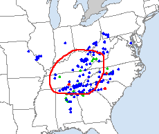
This is why the people who work at the NOAA went to school and get paid to do this. I drew the red circle as more of a guide to show the target location (maps below). Blue dots represent wind damage, green is hail damage and red is tornadoes. It appears that three tornadoes were reported and from what I've read, the one in south central Tennessee included a fatality, though I haven't seen confirmation. That's the unfortunately part of this but what researchers are also hoping to get more information to better predict and warn the public.
Map posted yesterday from NOAA Storm Report today
As far as our weather is concerned, the GFS tonight pushed the heavier rain this weekend into later Sunday night into Monday. I'll take that over a wash out of a weekend. The storm on the 10th is still there but the question remains how cold will the air be. It looks like highs for that time will be in the upper 30's. And quite frankly I think going any further than that would be pointless right now with how many times things will change.
My pro site days will be coming to an end soon. I have enjoyed it and will miss a lot of the maps that are far more detailed than the freebies. In fact, I think I will head over there right now and put in my cancellation. It's back to the regular maps for me.


0 comments:
Post a Comment