Winter Weather Advisory

Yearly Comparison

>> Monday, December 15, 2014

After sitting down and looking at the models I wasn't going to post.  Here we go with the back and forth.  What makes it harder for me is that I only get one chance to look at these during the day and that is now.  I don't get the luxury of watching this play out.  For all I know these model runs could be throwaways.  Both the Euro and GFS backed away from the coastal storm.  They do still show snow.  As much as I'd like to say you can count on snow this weekend you never know.  We've all been fooled before.  This is what makes it fun.

I ended up doing this post for a different reason.  As I sadly watched the Euro show almost nothing for the weekend the cycle continued to show a new coastal storm for the 23rd and 24th.  It's of no significance now except that it shows a continued chance of stormy weather.  The next ten days will be interesting to watch.  Once a track is set all you need are a few trains.  The track begins to take shape at the end of the work week which should also provide a lot more answers to what we will see over the weekend and into next week.


2013-14 vs 2014-2015


You know a winter is bad when even I'm ready to move on.  That's what happened last year.  Cold temperatures and consistent snows were all to frequent.  It made winter seem to last forever.  I heard something interesting the other day from a respectable source.  It was noted that the belief was this is the last of a series of consecutive nasty winters particularly in our area.  As a huge believer in patterns it is only a matter of time before we have a few years of above average temperatures in winter with little snowfall.  All that remains to be seen.  So let's see just how close this winter and last winter will end up.

November 2013 - Average temperature (-4) below normal, no snowfall
November 2014 - Average temperature (-4) below normal, 5.7 inches

Think about that one for a second.  As bad as it was last year we didn't see any accumulating snow in November.  It was just colder than normal.  This year it was colder than normal and we had snowfall.  Allentown averages less than an inch of snow in November.

December 2013 - Average temperature (normal), 13.7 inches of snow

So far this December has been warmer in terms of temperature and there is one huge reason why.  If you haven't noticed December began by resembling the ugly sister of November.  8 of the first 11 days had measurable rain.  The sun has seemed to disappear.  Because of this the nighttime temperatures have not been able to drop often.  With at least two chances of snow the 13.7 inches would not be a stretch.  My guess is the month will end up pretty close to last December.

Will the pattern continue?  Many would hope not.  Last year ended with 68.1 inches of snow.  It was the third snowiest winter in recorded history.  Can we get into the top ten again? 

Read more...

Winter Storm Chester

>> Sunday, December 14, 2014

Details


  • Date:  December 9, 10, 11
  • Impact Areas:  Northeast
  • Peak Winds: 40-60 mph along coast, Fairhaven, MA 62 MPH
  • Snowfall:  Jamesville, NY 26.2 - Orwell, VT 19.5 - Savoy, MA 16.9
  • Notables:  NYC 2.63 inches of rain - Boston 3.20 inches of rain 


And the models have trouble figuring out exactly what is going to happen?  Not hard to figure out why.

I did most of my summary of this storm in my last post so this one will be short.  Since I decided to name nor'easters as a poke at TWC for naming winter storms I'm at least getting some amusement.  So far I'm on letter C and those guys are on letter D.  I have criteria for earning a name.  They do not.  So either it is almost not snowing anywhere else in the country or they don't know what the hell they are doing.

Back to the storm.  It ended quickly after my post with the moisture shutting off.  Have to admit the models did a good job with catching that wrap around snow.  In fact aside from the extremely high amounts the GFS had one night, it also did a particularly good job in showing that the Berks area had a higher chance of receiving accumulating snow.  You can see it in the GFS images and in the snow prediction map.

The final results for the three day storm came in with over 100 places reporting.  Nobody came close to Berks.  Hamburg reported 5.8 inches.  Fleetwood was at 4.2.  I was not correct in my official Allentown guess of 0.7 inches.  Probably going to be difficult to get one of these right unless I predict they get nothing.  They ended the storm at 0.6.

LOOKING AHEAD ----

Things quiet down this week with no chances for any surprise snowfalls and a return to seasonal temperatures.  Actually they have been seasonal in terms of average daily temps, but that is for another post.

Keeping an eye on the time frame just before Christmas.  A very close eye.  Clearly too far from now for any certainty but the Canadian and Euro both show something.  There will be colder air in place and it looks like there is a potential for a coastal storm.  Date range is between the 21st and 23rd.  Actually the GFS just updated so how about a little preview.


Even kept the date on there as you can see at the top right.  At least there is something to follow during the week.

Read more...

Let's Hear It For The Band

>> Thursday, December 11, 2014

It's always funny to see how a matter of a few miles can make quite a difference.  I woke up this morning to see a very light coating of snow on the ground.  It was just enough to make me smile and think, sweet!  Little did I know that it was actually still lightly snowing.  By the time I left for work it was snowing fairly heavily.  It didn't stop for the rest of the day.

There was never a doubt this was a storm with a lot of energy.  If I could take a moving picture of the water vapor it would have resembled a huge inland hurricane.  It had the exact same counter clockwise rotation which has caused this very consistent snow today (in some areas). 


I went and found the image anyway and even though you can't see the movement of the storm I drew arrows.  This is current at 8:45 and the storm is into the third day while still producing snow.

Oddly enough, the Lehigh Valley had no winter weather advisory today.  Tuesday morning we did have one.  I even had the picture posted on Monday night.  I wasn't convinced that it was necessary though there is no way for me to know since any frozen precip that fell would have happened in the middle of the night.  The National Weather Service called for potential accumulating snowfall today.  No advisory.  It was probably needed.  These are the joys of weather.

There is no way of knowing exactly what is going to happen at an exact time in a precise location.  If you really want to get detailed accurate information get yourself a weather station.  At least then you will be able to know what happened after the fact.  At some point today a band of snow went swinging through in a similar fashion as the arrows above show the clouds moving.  The swing slowed down at a point centering itself around the Lehigh/Berks line.  When it looked like it would peter out another small band of snow set up in the afternoon.  It left enough for plows to come out and snow blowers to crank.  Bizarre.

I can tell you how centralized this was.  When I left work there was probably around two inches of snow on the car.  The grass and everything was covered easily.  Plows had come through the parking lot.  When I arrived home there was virtually nothing.  That's right.  Practically bupkis.  It's basically a 12 mile drive.  What's also amusing is as much as I follow news during work there was almost nothing coming in about the snow.  Nothing from the Allentown news or Philadelphia.  No joke the only thing I saw mentioned was from the Reading Eagle that said Fleetwood-Blandon road was very icy and use caution.  It was like it only was snowing in a 5 mile circle.  Here's some more for you.  Of all the snow reports for today that came in, the lowest total in Berks was equal to the highest total anywhere else in the Mt Holly region.


My original intent tonight was to give a wrap up of this snow.  Instead the wrap around snow continues.  In fact the main batch of snow is now centered squarely in Pennsylvania.  As I checked the radar I noticed the snow filtering back in from the northeast.  This time it is further south.  While the snow is trying to push back close to the areas that already saw a decent amount, it has been snowing here for an hour and everything is white.  If the band sticks together another inch is possible  Head to Emmaus and they will once again see nothing tonight.

Since I did actually make one prediction, which looking back was probably a good thing since the snow is all over the place, I will eventually get around to figuring out what the official total for Allentown was after this wraps up some time early tomorrow morning.  Can't wait for winter to actually begin. 

Read more...

Storm Number Three

>> Monday, December 8, 2014

Even though our particular area won't see a major snowstorm there is a lot in play with this storm.  Take a look at the watches and warnings.


It's actually very interesting to see this map because of all that is going on.  Another classic case of a nor'easter.  You can start in the southern portion of the map where Baltimore and Washington D.C. have no watches whatsoever.  Meanwhile all of Delaware is either in a Coastal Flood Warning or Watch.  The same can be said for most of New Jersey.  However many places have multiple warnings and since you can only use one color per county, there is more to the story.  Take Atlantic City.  They have a Coastal Flood Warning, Flood Watch and Wind Advisory.  Other counties like Hunterdon, Bucks and Montgomery have both a flood advisory and winter weather advisory.  Even the open ocean is covered with gale warnings, craft advisories and high surf warnings.  Move inland and at a point where Lehigh, Carbon and Schuylkill counties meet there is a winter storm advisory, watch and warning within miles of each other.

Off we go.

In technical weather terms there is a boat load of moisture to work with.  See model image below for amounts according to the GFS.


You can see a large area of 1-4 inches of precipitation.  Now the GFS has been consistent in doing something interesting.  Take notice of that darker shade of orange centered by Berks County.  I'll get back to that later.

Here we get the snowfall prediction from NCEP. 


Logically this makes sense.  The snow is confined to the interior and in places that are naturally hillier.  Have to remember a decent amount of warm air is being kicked back in from the ocean which plays against having snow close to the coast. 


The GFS becomes an entire different story.  I'll post a few images.  Remember that bright orange spot from above.

This is after the brief transition from an icy start.  Temperatures have risen and we are in the heaviest part of the rain.


Now this model and in older runs of some others, there has been this massive amount of moisture thrown back

As the warm winds change direction from coastal to winds out of the north, temperatures quickly drop back down.  In my experience though this usually happens after the moisture has is already passed.  This storm set up is allowing for another low to form and contribute to this extra moisture that if the models are correct tends to place the heaviest of this banding back over the Lehigh Valley as you can see above.


This is the very next image from the GFS.  Remember, we are talking a six hour difference.  Notice the dark blue is still over our region.  In this image you can also see the two lows that have formed.  If I'd post the next image it would still show us in a heavy band.

Now is all of this a possibility?  It's hard to predict what's going to happen when one low bombs off the coast let alone two.  I'll give you possible but extremely far fetched at least to what this shows.  If I recall I believe there was a storm last year that provided a decent amount of wrap around snow in a narrow band.  Otherwise it doesn't happen often.   And when I say doesn't happen often I mean not in the sense that the GFS shows.  My theory is that 9 out of 10 times it doesn't happen.   

This is where it gets either funny or awful.  I can't be the judge yet.  Last storm I used the GFS model for NYC to show our own potential snowfall.  After all the crap the GFS produced leading up to the storm the totals the night before ended up being more accurate than I was guessing.  I kid you not, this is what it shows for the system moving through tomorrow and tomorrow night.


There you have it.  Apparently we are looking at somewhere between 10 and 16 inches tomorrow.  Odd how extremely centralized it is too.  Really not even sure what to say.  If we got a quarter of this I will never make fun of the GFS again.

Moving on to reality.

The NAM just updated and it too kicks back snow which again I'm not doubting.  The amounts though with the NAM are far more realistic.


Looking at this one it resembles the first snow map I showed.  By the way the Euro is also very similar with a slightly larger area of pink shades but otherwise very close.  I tend to think this will be very close to the final totals.  All of our snow comes from whatever is able to wrap back around.


The call.

The temperature was far colder today than I thought it was going to be though I also didn't pay much attention.  That should help any early moisture fall in a frozen form.  I still think rain wins out quickly with the way the storm is tracking so I'm not very concerned about morning issues aside from the normally tricky spots.  Rain and wind is the primary player tomorrow.  The snow is the most challenging aspect of the forecast.  There are a lot of variables.  If the temperature drops fast enough and there is enough heavy precipitation it won't take long for snow to stick.  I have trouble seeing more than a coating for most areas so giving an exact figure is tough.  Since I don't see much anyway my only guess will be for a place I know will report.

Allentown - 0.7

Read more...

Model Fight

>> Saturday, December 6, 2014

The weekend before the Thanksgiving Eve snowfall there was no inclination that anything would happen if you went with the GFS model.  The European started picking up on it days before the GFS finally started to come around.  This has been a common trend for at least the past few years.  Because of this most people trust the European model when it comes to coastal storms.  Now the two are ready to battle again this week.

Once again the storm was really nowhere on the radar of the GFS a few days ago.  Not the case anymore.  While I wait for the models to update let me put my two cents in regarding this event.  You can say it a thousand times and it never will change.  It's incredibly hard to predict winter storms in the northeast.  One day there is nothing and the next day a major storm.  In this scenario ever since the European started picking up something and now with the GFS shifting as well, one thing has remained consistent.  The bulk of this storm has stayed to our north and east.  That's why I'm not quick to jump into a storm type mode.  Nothing suggests we are in for anything major as of right now. 

Models:

Canadian-  Heaviest snow stays in the interior of northern New England.  Lehigh Valley gets nothing

GFS-  Agrees with Canadian with regards to New England snow.  Does suggest a small accumulation for the Lehigh Valley.  (Map included with total inches)


Euro-  Throws a lot of moisture into eastern PA with a bit of wrap around as well.  Due to temperature keeps snow totals north of Lehigh Valley but puts NE PA to Maine in 10 plus inches.


Now the one thing this won't pick up is the area of potential mixing.  I will have to do more research to see what maps might be out there for ice accumulation.  Obviously a lot of time between then and now.  Then being Tuesday into Wednesday.  No need to run out for bread and milk which I'm not really sure why those are the first two items people need in times of snow.  Beer, shovel and meats to throw on a grill seem higher priority.

Anywho, I will continue to investigate and whatever else that catches my eye will get posted.  Otherwise I'm not too concerned about what is sure to be storm C.


Read more...

Winter Storm Bastian

>> Monday, December 1, 2014

Details


  • Date:  November 26th
  • Impact Areas:  Northeast
  • Peak Winds:  N/A
  • Snowfall:  Laconia, NH - 16.5 inches - Orwell, VT - 16 inches - Binghamton, NY - 10 inches
  • Notables:  More than 400,000 lost power due to heaviness of snow

A rare Thanksgiving time snowstorm pushed through the area on Wednesday.  Due to the holiday I haven't even been able to take a look at this one until now, and quite frankly even at this point I don't have a ton of time to dive into the storm.  I'll make it as quick as I can.

In the way I saw it play out I was right in some areas and wrong in others.  I did expect higher totals than what was recorded for bigger cities.  I don't mind so much that I was off since I give specific amounts.  If I go with the general call of 3-6 or 5-8 or 6-10 I end up being right.  But when Allentown officially reports 4.9 when I guessed 7.7 it looks like I'm way off.  Realistically it is less than a three inch difference when all those I listed have at least a four inch swing.

In terms of what went right I think (and saw) how huge a difference elevation played in this storm.  And with that I was much more accurate in my call of double digits for the random hills.  I noticed throughout the area that a difference of a few hundred feet produced a very noticeable difference in snow totals.

I still don't have a go to city outside of Allentown.  Only spotters reported in Lehigh County which unless they were on a hill I'd say the report of 7.8 inches in Salisbury township is a bit high.  But again there is a big increase in elevation that could have easily played a part.  Easton did not report a total which makes me think they won't be consistent.  Bethlehem is out since the official snowfall total for the city of Allentown is taken at the airport which is basically in Bethlehem.  I did notice Nazareth reported through a weather specific program.  That might become the one to follow.  They recorded 5.5 inches.  Berks was all over the place which can be expected for the size and elevation differences.  I don't mind that Reading reported 2.7 inches but the fact that it finalized at 5:00 Wednesday evening when it was still snowing is comical.  I do tend to think that the rapid melting of the snow played a factor in measuring.  The reporting stations recorded totals above 7 inches in places near Fleetwood and Mohnton even though you wouldn't have measured that much.

I as always enjoyed the snow as much as a person could who spends most of a nine hour day in a windowless office space.  Even though my ankle is still sore and swollen I made sure that exactly one month after almost fracturing my ankle I made it a point to enjoy a snowy night.


Read more...

Day Before Storm B

>> Tuesday, November 25, 2014

Going to try something new this year.  I've got the ability to look at a lot of the same things the professionals have available to them.  The only thing I don't have is their amount of time to study all of it or their understanding of many of the finer details that allow them to do the job.  But this year I'm not spending one second checking out what the other sites have to say before the storm.  I can do that on my own.

I've been hovering around the six inch mark for our area, but I also think there is a pocket of heavier snow close by.  It's the last chance to look at the maps before the storm tomorrow.  Let's hit the maps hard.

North American


Two things from this image right when the storm gets cranking.  We are close to the mix line.  A slight shift and we end up in the mix.  I don't tend to lean that way because of how consistent this has been so far with calling for mainly a snowstorm.  The second thing is, as you can see, we end up being in a heavier snow band with this setup.

The North American runs images every three hours so I will post the next image in the series.


Still in the heavy snow.  After this though the storm wraps up quickly as it pushes north and east.  The other thing that you won't see unless I post all the images is that the storm continues to intensify as it moves up the coast.  Screw it, I'll post the next image too as it will help in my explanation.


Again, this is three hours after the second image.  Notice the back end snow coming through Pennsylvania already.  The storm is down to 997 millibars.  By the time the storm exists the coast off Maine it is down to 991.  It's the classic nor'easter.  You can also notice the tighter gradient in winds in the third image.  It reminds me of an unorganized tropical storm becoming an organized and tightly compacted storm.

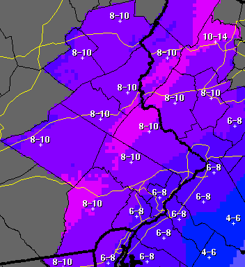
Now for what we really want to know.  How much snow.  Well according to the NAM, this much.


All purple is over six inches.  Darker shades are at the lower end and lighter closer to eight or nine.  Pink shades start pushing 9.5 to potentially a foot.  You can see those colors blending in to the purple in all of the Lehigh Valley.  That tells me you will get isolated spots of 10 or 11 inches especially in higher locals.  All in all I really cant disagree with this too much as of right now.


GFS MODEL NEW YORK CITY


I can at least say the GFS has been consistent.  There is part of me that wants this to be accurate only so I can use this for the rest of the season with confidence.  I'm not sure if that is going to be the case.  I like the bigger totals for the Poconos, but there is a lot going on here I'm not completely on board with.  I can't see how Berks and Allentown get less snow than places in Bucks and Montgomery yet places to the north get substantially more.  It's not impossible though.

EURO

Time to dissect our old trusty friend.  Unfortunately these can't be posted but yet again I agree with this one the most.  The best chance of snow stays north and west of the big cities.  All areas in the swath stay in a general six to eight inch range.  The heaviest snow runs between Connecticut and Maine in a 10-14 inch range. 


FINAL PREDICTIONS:  I might update this later or even in the morning if I get the time. 

If we get ten more snow storms I will say this ten more times.  This is a tough one.  I'm going to ride with my first instincts that I've had since Sunday.  My feel is the heavy snow band is very close to our area.  I think Reading sits in it briefly while a place like Allentown could sit in it longer.  Also of note since there are not many official reporting stations, Allentown's official total is reported at the airport.  The airport is north and east of downtown by miles.  It's going to help in totals for certain storms.  I will have to try and find official reporting stations so I can make specific guesses.  For now I can only really go with the bigger cities or areas.  And on another note, this year I am also only focusing on our specific area.  That means Berks, Lehigh and Northampton counties.  Or basically my current location and the Lehigh Valley.  It is the name of the blog after all.

BERKS:  Reading - 5.8 inches
-- Outside of the odd GFS run I'm staying a bit conservative.  For one I think the heaviest bands miss the area barely.  Missing those bands will also mean it will take longer for the snow to begin to stick and that doesn't count towards the totals.  Go east and north in the county and things could change quickly.  I'd expect bigger totals especially towards Lehigh County.  Just for comparison when trying to pinpoint areas, Berks is bigger in size than Lehigh and Northampton combined.

LEHIGH:  Allentown - 7.7 inches
-- Crazy right?  A difference of almost two inches between Allentown and Reading.  It's really not.  There can be such huge differences between places much closer.  You are looking at a distance of 50 miles here.  And I think the closer you get to Allentown the higher the totals will be.  Outside of some elevation differences I'd expect most of the county to be near a similar figure.

NORTHAMPTON:  Easton - 8.1 inches
-- They are going to be in that same band which is why I think the totals are similar.  I'm trying to keep some space in between cities which is why I hope Easton reports totals.  Even still it is only 15 miles from the Allentown reporting station.  But that's 15 miles due east which during coastal storms can play a big factor.  The county really shoots north which is why there will be areas that see more substantial snow such as Bangor which is probably looking at more than 10.

If you happen to live on a 900 foot mountain looking north in New Jersey I'd start getting the beer ready to line up along your shoveling route.  You are looking at double digits.


11:15 UPDATE

Well guess who is coming around with just hours left before the storm.  The GFS of course.


Heck of a difference from something I posted just a few hours ago especially in the Lehigh Valley.  Point is I'm sticking with my predictions.

Read more...

Watches Posted

>> Monday, November 24, 2014

Going to keep this one short since I'm starting at 10:30.  Okay, so I wrote that sentence before I even began to look at the models.  I just went to pull the data and wouldn't you know the latest run begins updating at 10:00 p.m. from the GFS.  Which means you have to wait until the update is completed before you can view anything.  So much for keeping it short time wise.

I'll start with the models that have already updated and end with the GFS.  The European has backed off the really high totals.  However the totals for Berks and Lehigh Valley would still be in the 7 to 11 inch range.  The foot plus totals stay to our north in New England.


Here is the North American model that goes out only three days so it is officially within the range.  Actually have to say I like this one a bit more than the Euro but they were similar.  Anything in purple is over six inches.  Any hint of pink is closer to 10 inches.  Lighter pink equals higher totals.


It's been interesting watching NOAA.  After I posted their totals last night they later went on to decrease the totals.  The same decreased totals were up this morning.  By this afternoon they had rebounded back to what they originally posted.  I'm not sure what they use to determine totals, but I have a feeling they rely on the goofy GFS which can be all over the place.  Here are totals from our local weather service currently.


Interesting cutoff in the Philadelphia area.  I'd say this and the NAM are similar.  Now we wait for the GFS to finish.


Don't see a lot of differences in this one and the one from yesterday.  Also have to remember this runs in six hour increments so each frame skips six hours.  So if I post the next image it would be of the storm six hours later.  In this case that would be the majority of the storm.  Even though it looks a bit weaker here, an hour or two later and this could be stronger. 

We end with the GFS run out of New York City for totals.  Not surprisingly it stays on the low side.  Also, I'm not choosing New York City over Philadelphia.  It's actually the only city in the northeast that shows close up totals so consider us lucky. 


Read more...

Thanksgiving Snowstorm 2014

>> Sunday, November 23, 2014

Here we go.

Over the past few days word started to spread that there was a possibility of a snowstorm for the time frame around Thanksgiving.  As we continue to progress towards the beginning of the week that possibility is looking more and more like a reality.

I can't remember a snowstorm around the time of Thanksgiving.  Snow certainly isn't uncommon but a major storm is.  Obviously this is poor timing for one of the busiest travel times of the year.  Hopefully though it also gives people a chance to stay inside with a few days off.

Let's get right into it.  I will be posting some model runs each day unless otherwise noted.  These models have really turned into a business (actually they have been for awhile) so there are fewer and fewer available to the public.  I'd suggest you come to this blog first and not even attempt looking for any.  I'll have the info and maps posted.  Again, unless otherwise noted.

POTENTIAL WINTER STORM B

No name yet since you never know.  Timing is around midday for the Valley on Wednesday.  A day or two ago the question of a rain snow mix was in the air. I think you can take the rain out of the equation.  The cold air is going to force its way from the north and west ahead of any precipitation.  Once the precip starts the air will just get colder.


This is the GFS image for Wednesday.  Pretty clear view of the storm intensifying off the coast of New Jersey throwing moisture back inland.  The 32 degree line is the blue line that you can see more clearly going through North Carolina.  You can follow it north and can see only the coastal areas of New Jersey at this time would be in the rain.


Sort of hard to pick up on here but this is the GFS snow total ending November 28th out of the NYC model.  Berks county is on the bottom left.  The number which I can only assume is over Reading is 6.5 inches.  If you notice the area in pink from outside of Philadelphia and up through the New Jersey those numbers are between 9 and 10 inches.  The number over what I guess is Allentown or maybe Bethlehem since it's on the county border is 7.7 inches.  Remember this when I post the same map tomorrow night.

The European model is very robust with snow totals however if you've been following this site you know that the European tends to be much more accurate in the long range.  The totals for just about everybody according to the European are between 10 and 14 inches.  No, I'm not joking.  The European models are not allowed to be posted so I will keep with the rule, and you will just have to believe me.

The shorter range models will start to pick this up tomorrow.  I didn't check the Canadian or Japanese because one, the sites are really slow right now for obvious reasons.  Two, at this point I don't need to check when the two main models both agree on a storm.


Here is what our local National Weather Service is predicting at this time.  The generally go conservative to start so I wouldn't be surprised if this increases.  I'll post their updated totals tomorrow as well.

Expect the watches to pop up sometime tomorrow.  This looks like our first storm of the season.  Who thought we would have a white Thanksgiving.  At least you can get in some exercise before eating too much food.


Read more...

You Can Put It On The Board

>> Friday, November 14, 2014

YES!

I had thought for sure that my first taste of winter would come on some 1,000 foot hill during a trail run watching snowflakes fall in a county north of here.  Or at least that is how I planned it in my head.  Turned out I didn't have to go anywhere.  Not only did we see our first snow but also knocked out the first accumulating snow.

Mark it down as November 13th.  I don't recall a forecast that mentioned accumulating snow.  A flurry maybe.  That's how weather goes.  I got the news while I was sitting in my windowless office.  It was snowing out.  Wait what?  If anything I thought it would be much later at night before a changeover took place.  It took me all of 7 seconds before the four-year-old in me had to get up, walk out of the office and go see for myself.  Indeed it was true.  15 minutes later and a co-worker who had already left work called and updated me on conditions.  Some of us just can't get enough.

It kept snowing for a solid four hours though it didn't really get to sticking until the sun had set for an hour or two.  By that point the flakes were large and a coating quickly showed on colder surfaces. 


It's not great but I do have proof of the snow.  Granted I didn't try hard to get a good picture as I snapped this one after getting back from my hockey game.

Next is a morning shot of the snow from the prior evening.


For a system that wasn't forecast to produce much of anything there were some decent reports coming in.  Now I'm going to state this now before any more snow falls this winter, but I have a hard time accepting some of the reports that come in even if it is through a trained spotter.  I'm a trained spotter, and I wouldn't trust myself to be accurate.  Some higher local locations reported between 3 and 4 inches around the Lehigh Valley.  Berks had amounts close to 2.5 inches from trained spotters.  I know where I was it wasn't close to that.

Officially Allentown reported half an inch.  These measurements are taken at the airport using a weather observation system.  It's basically a 24 hour system that updates every minute.  I'll take that reporting over the guy who measures snow in his yard with a stick (or if done by standard spotter rules, a piece of plywood) every few hours.

Plenty of cold air for us next week.  Not so sure about any snow events.  Small chance Sunday night and even smaller on the backside Monday.  Otherwise it doesn't look like we will see another snowy scene for a few weeks. 


Read more...

Winter Storm Artimus

>> Thursday, November 6, 2014

Details

  • Date:  November 1st - 2nd
  • Impact Areas:  TN, NC, ME
  • Peak Winds:  70 mph - Nantucket, MA
  • Snowfall: Mount LeConte, TN - 22 inches -Spring Creek, NC - 22 inches -Cary, ME - 21 inches 
  • Notables:  Measurable snowfall in western and central South Carolina, 150,000 lost power in New England

Forget the fact that most of the northeast missed out on snow entirely while Greenville, South Carolina saw half of their seasonal snowfall already.  There hadn't even been a major snowstorm anywhere in the country before the southeast was measuring with a yardstick.  If this is any indication of the year to come, the east might be in for a treat.

As odd as this storm was for the time of year, evidence is beginning to show that the snowy pattern could persist.  The consensus is the southeast will be well below average in temperatures this winter.  Think on the scale of three to five degrees which is significant.  Think of our winter last year.  Between November and March we averaged just about four degrees below normal, and I think we all remember how cold last winter was.  The issue with the south is that even in a cold winter temperatures still might not be cold enough to support snow. 

It still is a little too early to tell how the winter will unfold.  There is also a slight sign that arctic blocking could develop shortly which could signal the beginning of the coastal storms.  With the threat of the polar vortex again this year, making an appearance next week in the central U.S. and sliding east, and a possible blocking set up one can't but help to think this is setting up to be another above average snow season. 

Here is what Artimus showed me.  The pattern changed with this storm.  It happens every year before winter begins and when winter ends.  After all the awesome weekends we had, the first one in November brings a snowstorm, rain, winds and cold.  This weekend we experience our coolest temperatures since last weekend.  And there will be another snowstorm in Maine.  Here is what else I learned and already knew.  Winter storms are awesomely amazing.  I'd love to be shocked by the pictures of three inches of snow in South Carolina, but I'm not.  You never know what is going to happen.  I will admit I'm much more impressed by the few inches at low elevations then the 20 plus inches in the mountains.  Those areas are so under appreciated for their winters.

With my own new naming system I hope to be able to track east coast storms with news, pictures and videos.  Artimus hit before I even knew I was doing this so my content isn't the greatest.  I also realize with the possibility of a storm this weekend that meets my characteristics we might have more storms than I originally thought.  This probably has to do with me not paying much attention to storms that don't have a huge impact on any area close to me.  Either way I will have a summary of any nor'easter if it qualifies. 

Locally our weather goes downhill next week especially as the polar vortex sweeps in during the middle portion of the week.  It's also a good time to start looking at potential storm systems to produce our first snow of the season.  As of now there is nothing imminent but as I said earlier you never know what is going to happen.     

Read more...

Naming Rights

>> Monday, November 3, 2014

Over the weekend parts of the Appalachians were blanketed with a very rare early season snow with higher elevations doing very well.  But it wasn't only the high elevations of the south that received snow on the first day of November.

If you are wondering, the storm did not have a name associated with it.  Fear not friends, the folks at The Weather Channel once again are ready with their lists of winter storm names for the upcoming season.


If the names and system for naming storms seems stupid, it is.  I expect the reasoning why this past system was not named was because it didn't affect a large enough population.  The snow was centered in the mountains of the Appalachians and the northern parts of Maine.  This is precisely why the naming system has had little support when there are no set standards.  I don't necessarily hate the idea of naming winter storms however the only storms I can see naming are nor'easters as they have characteristics similar to a hurricane that can be categorized.  But for TWC that would alienate most of the country except the east coast.  I live on the east coast and don't care about a bias.  They can use their system and I will use mine.

Here we go.  These are the simple rules for obtaining a name.

1.  Must be a Nor'Easter or energy associated with it.
2.  Contain winds of at least 50 mph
3.  Snows (at valley level) must exceed 10 inches

That's it.  Very simple.  I should explain the first one as it has the potential to be confusing.  It's easiest to explain with this past weekend storm.  The snow that fell in New England was the classic nor'easter.  The snow in the south was not, but it was part of the same batch of energy.  Therefore that snow will count towards the entire storm.  It would not have received a name had it only snowed in the south though.  It wasn't a nor'easter at that point.  It would be rare for a batch of energy to only produce snow in the south, transition to a coastal storm and not doing anything in the northeast so I think we will be fine with the standards.

The wind is standard.  Doesn't need to be sustained.  Gusts are fine.  Snow is obvious.  By valley I only mean I'm not going to name a storm because Mount Washington receives a foot of snow but everywhere else only gets rain.  That is an actual spot that doesn't affect anybody outside the few people at the observatory.

My names will go in alphabetical order from A - Z and be picked randomly.  Many of them won't make much sense like many The Weather Channel uses.  If they can have fun this year so can I.  My next post will be a recap of the first winter nor'easter of the year.  Storm A. 


Read more...

Guess Who's Back

>> Saturday, November 1, 2014

Let the 2014-2015 winter season begin.  This blog has officially become a seasonal site.  Even though it's not the official start of winter or even the meteorological, I consider the season to run from November 1st thru March 31st.  Any snows before November or after March are added bonuses which have certainly occurred in the past.  With winter storm watches and warnings peppering the Appalachians in Tennessee, Virginia and North Carolina, together let's enjoy the next five months.

It's brisk, damp, dreary, wet and chilly as I sit here peddling my first article of the season.  Hold on a minute.  My suspicion has been confirmed.  It's November.  Welcome to one of the crummiest months of the year.  If the cold, damp air wasn't enough of a punch in the face, tomorrow's 30 mile per hour winds will surely blow away any remaining summer tan you are desperately holding on to.  The lack of sunlight will seal the deal when the second day of November brings the new sunset time to before 5 p.m.

I've expressed my feelings on this time of year for quite some time, but it's not just me.  Our culture has embraced the month for what it is.  Now you're thinking, Ryan please enlighten me.  Gladly.  Every month brings certain sights, sounds and thoughts.  Even music can portray certain seasons from Summer Breeze or Under the Boardwalk to the cheerful holiday music that is a few weeks away.  I can't take you down to the paradise city as by no means do I consider myself much of a GNR fan, but the band did supply one of their most iconic songs that also became the unofficial song of November.  It's lengthy but if you are unfamiliar have a listen.


The song is approaching 300 million plays through YouTube.  It's a well known tune.  A good old power ballad from a band that is not known for this type of sound.  With a name like "November Rain" you kind of already know what to expect.  No uptempo song here.  

Within the first ten seconds of the video you get a blustery wind, dark room and the sound of rain hitting the ground.  As I sit here looking out at the trees swaying on this overcast day through a window dotted with raindrops I'd say we are off to an accurate start.  Each time we see a scene of light it transitions quickly to dark.  Another good representation of the constant changing weather in this beautifully ugly month.  Then the slam dunk.  The last line of the refrain.  "In the cold November rain."   I'll move on.

Movies you ask?  Indeed there are movies that highlight or at least touch base on the month.  In fact just this summer Pierce Brosnan starred in The November Man.  Take a look.


Whoa whoa whoa.  What did he say?  They called him the November Man because once he came though everything was dead?  I can't help but laugh now.  Even a nickname and movie title use the basis that everything dies in November.  Once again I agree on the perception and will move on.

It doesn't help that the month is sandwiched between two of the more vibrantly colorful months.  October screams of autumn with the changing of the leaves to brilliant colors.  If October had an official color it would be bright orange.  And if gluten has become our biggest enemy, pumpkin has become our new bestest friend.  That stuff has made its way into everything.  Then December comes calling with its month-long celebration of Christmas with songs, lights, shows, goodies, decorations and Jesus.  How can November compete with Jesus.  It's also the one time of the season when most people are actually hoping for snowstorms so that people can celebrate a white Christmas, just like the ones we all use to know.

Thank goodness November has a holiday.  The motto of the month should be "At least we have Thanksgiving." Truthfully it really is one of the better holidays of the year.  But continuing with the sights and thoughts associated with months, what color represents Thanksgiving (and November) best?  For me it is simply.  Brown.  My guess is most agree.  Freaking brown.  If you type in the word Thanksgiving or November into an internet search you literally get dozens of pictures that are generally surrounded by brown.  The trees are bare, the grass is dead, the turkey is brown, the Pilgrims wore brown, the Indians wore brown, the leaves that were once colorful are now delicate pieces of brown mulch.  People will tell you the colors are rustic or earthy.  Those words aren't in November's vocabulary.

Thanks to the Rodale trails for the first time in many many weekends I won't even be able to get out during this first weekend of November.  Not that the conditions are optimal anyway.  Remember all those perfect weekends over the last four or five months that never seemed like they were going to end?  Over.

Now we wait for the first flakes of the season.  It won't be next week but once we hit double digit dates I'd start to take notice.  

Read more...

Impressive Hail Storm

>> Thursday, May 22, 2014

Large hail is uncommon for our area.  Receiving significant amounts of hail is too.  That changed today reminding us how quickly weather can change.

Slightly before 4 p.m. a strong and powerful supercell formed and moved through Reading.  What it lacked in size it made up for intensity.  At the time I wasn't following the radar.  I didn't need to where I was at.  It was only after I happened to check my phone that the news started coming in about the hail storm.  Soon half the office was gathered around radar maps and checking phones for the latest images. 

Car windows were broken.  Highways were at a standstill because of the damage to cars.  People were holding up pieces of hail bigger than golf balls.  There are hundreds of pictures out there so I'm not going to go through all of them.  For records I am going to post a few to remember this event.


This photo was widely circulated of a motorist pulled off to the side of the road with clear damage to the windshield and hood.


From Twitter User Ashley Reed:  The Wyomissing area was hit particularly hard which contains much of the shopping areas for Reading.  Wyomissing and West Reading saw the most damage to cars and businesses.

When I left work I wondered how long it would take before I would start to see signs of the storm.  It was so small in size that I knew it would be a matter of a mile or two between nothing and something.  It wasn't until I got to Route 61 that I started to notice large piles of leaves on the ground.  It was the first sign that hail fell on the area.  As I turned into the complex under every tree was a pile of leaves.  I pulled into my parking spot and noticed the ground looked odd.  Well after an hour had past and the signs were still there.


This is what was left all over the ground even though the temperature was in the 70's.  I have no idea how long it was sitting there, how much accumulated or how big they were.  No cars in the parking area were dented outside of one that I assumed came from somewhere else before parking.  Got lucky.

Luckily when I went to the gym the TV was already turned to ABC 6, the station I normally watch.  Obviously the coverage would center on the hail storm.  When Cecily Tynan came on the first thing she mentioned was that in the 19 years she has been with the channel in Philadelphia she has never seen anything like it.  When the ABC Nightly News came on at 6:30 the very first story they had on the national news was the hail storm and this picture.

 
I can't say I would have liked to have witnessed this but at the same time I would have liked to witness this somewhere safe.  This storm came in so fast that nobody would have been prepared.  It also makes you think about weather far worse than this event.  This type of day is exactly the same as what people in the south and midwest experience before a tornado.  It was sunny outside.  There was no sign of bad weather approaching even at two in the afternoon.  Two hours later and hundreds or maybe thousands of cars suffered major damage.  Wyomissing just happened to be the spot today.  It could have been where I lived or worked.  It could have been my car.  And this was only a hail storm.  Nobody lost a house or family members or all possessions. 

Weather is unpredictable.  Almost anything can happen at any time in any place.  We are actually all lucky because many times cells like this produce tornadoes.  Going through a heavily populated area would have been bad.  With the severe season beginning as well as hurricane season on June 1st, things are only going to get more interesting.  Word on the street says the thinking this year is hurricanes will trend further north than normal with the hot spot being between North Carolina and New Jersey.  Let's bring back winter.

Speaking of winter I'm pretty sure that the snow is officially over which means I must post a year-end recap.  Thankfully I did not see or hear one person say sleet today.  Not sure it means anything though as most people still don't understand the difference.  The next post will be my winter recap before dare I say I do a first time hurricane prediction this year.  Why not.

Read more...

Going for Gold

>> Saturday, March 1, 2014

This would have been a great year to hold the Winter Olympics in Pennsylvania.  Cold air has been plentiful as too has the snow.  Erie leads all cities in total snowfall as of today.  Philadelphia only trails Chicago in most snowfall for cities with more than one million people and sandwiched in between is Allentown.

The last time we spoke Allentown was currently sitting at their 4th snowiest recorded winter.  Philadelphia sits in the bronze position dating back to 1884.  Allentown would need 8.7 inches to reach the top spot.  Oddly enough Philadelphia's record snow, recorded just four seasons ago, is higher than that of Allentown. Philadelphia would require 19.2 inches to eclipse that mark.  They did pick up an additional 1.1 inches this week and are within reach of the second spot.

The calendar has officially changed to March.  The weather won't be changing.  February was a month to remember.  In Allentown the temperature averaged six degrees colder than normal.  That's a lot.  The snowfall for the month was 36.5 inches.  That's more than the seasonal average.  If you now take November, December, January and February the temperature has averaged 3.5 degrees below normal.  It might not seem like much, but that number is very unusual in it's consistency.  The first two weeks of March are also projected to be below average which got me thinking.  If we assume March is also colder and snowier than normal and we don't exactly know what April will bring, it's possible you could be looking at a six month period of winter-like weather.  Ring your noggin off that one for a minute.  Even the hardiest of us have to laugh at that concept.

But the real reason we are here is to discuss the title of this post.  The snowstorm that could break an Allentown record. 

It's certainly not unusual to get a snowstorm earlier in March.  I'd love to go back and see how many we have had in the first week of March as I remember there seemingly being one every year when I was in grade school.  In fact some of the best and most powerful storms occur in March because of the increase in energy and moisture as the arctic air battles the return of warmth from the south.  If you remember the "Storm of the Century" back in 1993 when places from Alabama to Maine saw upwards of 20 inches of snow with many pockets of over 30, the date would have been between March 12th and March 14th. 

We aren't going to see that this time since it is tracking from west to east and not up the coast.  However, that doesn't mean we won't see some impressive totals.  The question as always is where will that be.

I've been onboard the express train to Philadelphia all season long.  I'm not getting off now.  Everything is suggesting the further south you go (to a point) the more snow you are going to get.  So if you drove from Scranton to Allentown to Reading to Philadelphia, the totals would progressively climb.  The bulk of the moisture is trying to go through Maryland and D.C.  Not only that but temperatures are going to plummet during the storm especially for places to our distant south.  At the onset temperatures in D.C. could start in the 50's before ending as heavy snow in the 20's.

For us it becomes more of a factor of where the heaviest bands set up.  Right now the suggestion is along the Mason-Dixon line to points just north.  Philadelphia would see a solid 10 inches or more.  With temperatures being as cold as they are it would not be out of the question for places like Reading and Allentown to end with similar totals even though there would be less moisture.  At this point I'd put Reading and the Lehigh Valley closer to the 8 inch mark.  In fact I will say Allentown picks up 8.6 inches just so they trail the record by a tenth of an inch.

Not like that would matter.  There is still a whole month to go even after this storm.  At this point we might as well shoot for 80 inches.  10.5 inches gets Philadelphia to 70 for the season.  It would only be the second time they have ever done that in 130 years.

If anything changes tonight into tomorrow I will post.  Otherwise I'm holding on to the 8.6 and 10.5.  Anybody ready for summer yet?

Read more...

Rising Towards the Top

>> Tuesday, February 18, 2014

I'm not sure how this winter season will end up ranking compared to past winters.  I guess it could be a matter of opinion.  Numbers don't always give a clear indication.  What I have taken away from the season so far is the persistent nature of snowfalls and the steady stream of coldness.

We can start with the facts about this winter taken from recordings at Allentown Airport.  Including today the snowfall this season is at 66.7 inches.  That is 4th all time since recordings began in 1922.  Ahead of this season is 1993-94 (75.4), 1995-96 (71.4) and 1966-67 (67.2).  Considering the late February to early March outlook it would seem likely we at the very least move into second place if not first by the time winter is over.  Anything over a half inch will place the three snowiest years within the last 20 seasons.  Maybe that will put to bed the stories of the old timers telling us how high the snow was in their day.  The answer is apparently not as high as today.

This season we have had so far:

  • 22 days of measurable snowfall
  • 12 days of temperatures that fell to single digits
  • 6 different days the low fell to negative numbers
  • 31 days the high temperature failed to reach 32

Unfortunately I don't have the ability to compare this to anything historically.  However I could easily say this is unusually.  For instance, the average temperature in January was five degrees below normal.  The average temperature so far for February is seven degrees below normal.  It doesn't seem like a lot but it is.  December was right on average and November was three below normal. 

This type of weather starts lending itself to the cries of forecasters reassuring the upcoming warmup.  A normal winter has many ups and down.  Hitting 50 twice after all this cold must be like saying it will be 70 to many.  Here's the full story.  The following two weeks after this weekend will probably see temperature on average around 10 degrees below normal.  Ten degrees.  Two weeks.  Enjoy those 50's.

If we are going to break snowfall records this is going to be the year.  Everything added up to keep the cold air in place and the moisture flowing.  The next few weeks will not be nearly as active.  That's probably a good thing at this point.  It doesn't meant that there aren't chances for snow.

So by the time March ends (or April the way this is going) could we call this the worse winter in recorded history?  You could.  Will it be the snowiest?  I'm going to guess that it will.  Hitting that number one spot would make this the greatest winter ever.  Not the worst.  It's all how you look at it.


Read more...

Pre Valentine's Day Storm of 2014

>> Wednesday, February 12, 2014

Winter storms always have the possibility of changing right up until they hit.  Hell, they can change during the middle of the storm.  As I worked and meteorologists studied maps it is becoming more evident this has the makings of a big storm.

I didn't think I was going to get to make another post, but the National Weather Service has changed their idea today so I figured why can't I.  I was always told if you can't trust the accuracy of a government agency who can you trust.

If you look at my post below you will see the totals they were going with right up through this afternoon.  Now it looks like this.


Widespread totals of double digits for Allentown and Reading as well as much of north western New Jersey and extending into the Poconos.  Philadelphia deals with some mixing.

Remember that darn North American model that wouldn't move the moisture as far west as others?  Here is what it picks up now.


The yellow to orange colors are at least 1.5 inches of rain.  What makes this one a little different is many areas in the heavy moisture will deal with mixing or a change to rain.  Our area is in one of the best for all heavy snow.  In this setup you are looking at upwards of 15 inches.  If you look around the NYC area you are probably getting closer to 20.

What makes this storm interesting to many is the size and area this covers.  You already have a major ice storm in the deep south.  Heavy snow between 10 and 20 inches will fall from Virginia to Maine.  It won't hit the big cities quite as hard as the interior cities but nonetheless this will make the history books simply because of the range of impacts.

Warm air might actually give us a little change over at some point.  Frankly that will just makes things worse.  It's already going to be a heavy snow.  We don't need to add to the weight with sleet or ice.  Let's stick with the snow and hope everything goes well.  Unless you have an important job that needs to keep you out tomorrow, enjoy the snowfall from inside.  I haven't really seen anybody predict less than 10 inches for our area.

We got lucky last time.  I'm not sure how lucky we will get this time.  Snowstorms are awesome until you lose power.  Assuming I am home and with power I will update when I'm not outside rolling around in the snow like a puppy.  Otherwise you will most likely find me outside enjoying every minute of the last major snowstorm of the season.  Who could ever get tired of this?

Read more...

Going to the Maps

>> Tuesday, February 11, 2014

The issue I was having that apparently many others are not is that even after waiting around those pesky North American models were not picking up the storm very well.  The heaviest moisture stayed closer to the coast.  Meanwhile the models like the Euro, Japan and Canadian keep pushing the storm even further west which would mean rain for the coast, a mix for I-95, and heavy snow for the suburbs.

Here we meet again waiting for the final run I will get to see before making my last post before the storm.  Actually I haven't even looked at it yet.  Let's see if anything has changed.  Alright let's try something.

In anticipation of seeing a change I grabbed the run from last night that kept me cautious about this storm.


The heaviest moisture is the orange while the lightest is the purple.  You can draw a line from the ocean to the mountains to go from heavy to light.  This is the one from last night.  Berks and Lehigh are in the lightest of blues.

Now 24 hours later this is what we see.


We can agree the heavier moisture is moving further inland.  With at least another 24 hours before the onset of the storm the question could be how much further does it move. 

The picture above would illustrate an 8-10 inch event in Allentown and Reading.  Snow would extend from Philadelphia and Trenton north and west with those areas pushing the foot plus range.  The problem is most are already throwing this one out (I'm not yet) because the others trend for big snowfalls to stay a bit further inland.

I'm not going to beat around the bush or use anymore ancient phrases.  I said last night I would go with what I thought and not worry about others.  Going into today I would have said most areas are looking at a foot as the low number for totals.  After seeing everything play out today I have less confidence in that idea.  Either way we are looking at a major storm. 

I pulled some storm totals from earlier this afternoon.  Some might have changed by now.

ABC says 10-14 inches from Lancaster to Reading to Allentown

CBS has a large area in 6-12 inches

Picture sums up this one from NBC

From the National Weather Service


EPAWA Group:  Red is 12-18 and Orange is 10-15


The fun part is I can't really say anybody is wrong.  The EPA guys as I like to call them tend to be aggressive with calls.  Sometimes it works and sometimes it doesn't.  They might be a tad on the high side.  I actually favor the NOAA call right now which is a little surprising for me because I generally haven't agreed with them this year.  Even though others call for a similar range I like my totals to be a little more accurate.  6-12 is too big of a range.  You could argue so is 12-18 but those are both already large totals.  What's the difference if you see 13 or 17.  12 is double the amount that 6 is.

Everything will start coming together tomorrow.  Once again power outages could be widespread with gusty winds and heavy snow.  By this time tomorrow night we should be well aware of what is coming.  I say should even though we probably won't.  These things always have a trick up their sleeves. 

Read more...

Here We Go

>> Monday, February 10, 2014

You know something is going on when winter storm watches are posted for Philadelphia days before the first flakes will fly.  Or when watches and warnings already extend from Georgia to Pennsylvania.  It usually means a couple things.  There is cold air to work with and a lot of moisture.

The reasoning the certainty of snow is already high is because all the big boy models have already agreed on a track except for the GPS which is notoriously slow to grasp the idea.  The agreement of models can certainly lead us towards the correct direction of a storm however with at least 48 hours of an open window for change I still can't go all in.

If we are going to get the big one this seems to be the candidate.  Even though a decent amount of snow has fallen, nobody in the northeast has seen that huge storm this year.  That could change.  In doing so, and with my belief in patterns, it could be the final KO punch of the season allowing us time to get up and move towards spring.

A lot of talk in the weather community for the northeast over the last week centered around the storms we already received and the one over the weekend that we did not.  This one didn't sneak up on anybody.  It's been on the model runs for just as long as the other storms, but it got buried behind the wave of storms.  It's finally pushed it's way to the front of the line and without us being able to see it from a distance, is becoming the biggest wave of them all.  Yes, I'm fully aware that my last comparison of winter storms was to trains but storms can be waves too.  Okay?

So here is the fun part about watching and waiting for models to come in.  They bounce around all over the place.  The shift, like many this season, was to push the storm further north and west then what was being picked up.  The model this afternoon did just exactly that.  Had I decided to show that one it would have looked impressive.  As I was writing this the run from tonight updated.  I figured it would push it even further north and west.  It instead took it south and east.  This is why I don't do a lot of commenting on storms too far in advance.  It could have been a bad run.  It could have been a sign that maybe this thing does stay closer to the coast and the overreaction has already begun.  I don't know.

I've been accurate enough this season that while I will read and take notice of what others are saying, I also will not put much stock into it.  They have had just as many missteps as anybody else.  It's weather.  What do you expect.  Meet me here again tomorrow night and we can pick up the conversation. 

Read more...

Ice Storm

>> Tuesday, February 4, 2014

This will be my last post ahead of the storm.  I'm going to keep this one short.

Normally I like to take a stab at what I think will happen during the duration of a storm.  This time I have to back off.  It is becoming more evident that warm air will set up in between layers of cold air to create a bigger icing event than I had thought.  I thought this because using my resources the temperatures never made it above 32.  They still don't.  But outside of other forecasts I have no way to tell that there is going to be a warm layer changing snow to rain and freezing it on contact.

This is what I can say.  After seeing the last run we are sitting in an area of almost 1.25 liquid inches of precipitation.  That's probably almost half an inch more than this past storm.  So whatever is falling is going to accumulate a lot.  If you notice our warning has dropped down to 1-2 inches of snow.  There is no mention of any change over to plain rain.  There is going to be an extended and heavy period of sleet and freezing rain.  It's enough to potentially cause serious problems.

Unfortunately this is exactly what we didn't want to see.  If you notice from the prior heavy, sticky snow the majority of trees and wires are already weighed down by multiple inches of snow.  The storm tomorrow alone could be enough to bring down trees.  Adding to what is already there is a recipe for trouble.  I expect to hear of many power outages tomorrow as well as downed trees.  Hell, nobody in PA has one yet but might be time to start throwing up some Freezing Rain Warnings.

Stay inside.  Be prepared for the possibility of no electric.  Or better yet, expect to lose power.


And a quick update on the weekend.  Regardless of what happens we are probably getting snow Sunday into Monday.  The difference will be a few inches or over a foot.  Latest run suggests the first option.


Read more...

  © Blogger template Webnolia by Ourblogtemplates.com 2009

Back to TOP