Winter Weather Advisory

Weekend Randomness

>> Sunday, March 11, 2018

While the temperatures won't show it, and they might not for a bit, it's always a sign that spring is coming when the clocks change.  If it was up to me we wouldn't go through this every fall and spring, but I have no say in the matter.  As much as I really love snow I have to give a few cheers for more sunlight in the evening.

Now for some weather talk and other random things from the weekend.

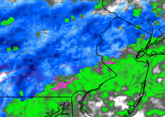
  • Turns out that snow map I was talking about last time for the storm right before we hit 80 degrees was saved to my computer.  At the time I was smart enough to do it knowing full well I'd have trouble finding it again.  Might as well post it now.


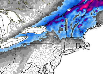
  • Very cool map somebody decided to make to show the current snowfall totals across the Northeast.  No doubt these numbers will continue to increase with another coastal storm getting ready to form.  Easy to figure out where the lake effect areas are.  That Erie total is nuts.  If you are keeping track at home the normal snowfall for a year in Allentown is between 32 and 33 inches.  Need to squeeze out a few more to get above and closer to my prediction. 


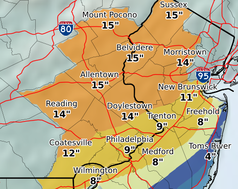
  • The third coastal storm was thrown out the window by a number of weather prognosticators I follow on various forms of media.  After the last storm I'm not listening to anybody when it comes to these storms.  I'm not sure why I do to begin with.  Well that storm is now taking shape.  New England could be in for a good one.  We will be close to the edge again while a place like D.C. as shown above will somehow avoid the snowfall.  Here are predicted totals (Late Monday night - Early Tuesday morning).  Take it for what it's worth.


WEEKEND SPORTS

  • In a battle of top four clubs, Manchester United took home a 2-1 win against Liverpool in action early Saturday morning.  That's great and all but what I took from the game was that Manchester United defender Eric Bailly scored an own goal that was so good it confused the graphics guys from NBCSN.


  • The goalie for Charlotte in the AHL scored last night.  Doesn't happen often especially considering he shot it in himself.


  • The MLS is back.  Missed penalty shots happen.  That rebound attempt...ugh.


One of the nice things about living in a more metropolitan area when it comes to running is that there are always new routes to try.  Yesterday before being sidelined by a mild migraine I decided to head for the hills.  Fountain Hill to be exact.  Went from one hill side near the hospital to the other hill side along the ridge of Lehigh mountain then through the Lehigh campus.


After a number of hours with my eyes closed followed by a night of sleep I was also able to get in my first 30 mile ride of 2018.  The weather has been tough especially on a Sunday morning.  That's one thing I won't miss when the warmer weather comes along.

Read more...

The Last 3 Storms

>> Wednesday, March 7, 2018

By now we are all aware that not all storms pan out in terms of predicted snowfall totals.  Some places get less than forecasted and other get much more.  It's the same with every single coastal storm.  Today was one of those times that our area missed the mark.  Mind you, it still snowed.  Other places ended up with next to nothing that thought they were getting anywhere from 4 to 8 inches.

I've been trying to piece together a summary of the last month or so to describe what we have been dealing with in terms of the roller coaster of weather.  I can't seem to figure it out.  The only thing I can say is to expect the unexpected.  Maybe that's the way winter will be from now on.  Or maybe that is how it has always been and we fail to remember since weather is constantly changing.  Instead of writing a summary of what we have been dealing with, I'm going to comment on a few topics I've noticed.

Let's start with February.

It was wet.
Of the 28 days, we recorded precipitation on 16 of them.  That's basically what we would see in summer months.   Receiving 5.50 inches of rain in a month that averages 2.70 has to be a bit on the odd side.  Maybe not.  In 2014 we got 4.45 and 2016 4.88.  In 2013 and 2015 less than two.  Let's stick with the odd/even pattern and say 2019 will be under two.

We set an all-time high record. 
On February 21st the high in Allentown hit 81.  That officially is the warmest temperature recorded in the history of Allentown.  Pretty crazy right.  Or is it? Thanks to record keeping I made this interesting find for the following dates.

February 23 had a high of 72.
February 24 had a high of 77.
February 25 had a high of 74.

Now here is the kicker.  All those temperatures were recorded in the same year.  And what year would that have been?  Last year.  Does anybody remember that because I don't.  So maybe hitting 81 this year (no other days broke 70) is not that crazy. 

This however might be.

It snowed 6.5 inches on February 17

Four days later it was 81.  What is this, Denver?  Let's get back to the snow event.  It would be fair to say this one came out of nowhere.  When storms usually are talked about practically 10 days in advance, this one performed a magical act to suddenly appear.  Not only that but the call was for a few inches at most.  It is here where I would have posted the snowfall results except I can't find where the weather service hid them, and I do not feel like spending time looking for it.

Into March we go.  A notoriously sneaky month for big storms.

A stationary snow band delivers results on March 2
This one was especially bizarre from my standpoint.  For context they never called for much snow in our region.  Most of the big amounts would be to the north.  Everybody would see a few inches.  So I kept tabs on the storm throughout the day and started to notice that while not much was happening where I was, the story seemed a bit different where I lived.  Driving home confirmed it on a larger scale than I expected.  The map, which is still available, will show how banding with coastal storms works.


I've added the red box to highlight totals from the day.  Look at Reading to the west which reported nothing.  Trenton to the east is at 0.2.  In the middle you have anything from 6 to 9.5 inches.  Bethlehem ended up reporting 5.6 inches which did not make this map.  Allentown (airport) officially is the 3.7 you see in the box at the top.  There is your example of a north to south heavy band that does not move.

That brings us to today.  When I woke up the NWS forecast was for 14 inches of snow in Allentown.  That would have been very accurate if you took away the 1.  Totals are still coming in and nothing is official.  The airport is a bit further west (every mile helps) so I'm thinking their total is not going to be anything above 5 inches.  Other areas in the region might be in the 5-6 range.  Still a very far cry from the call.  As mentioned before, it happens.  I'm more perplexed as to why the totals were not updated as the day went on.  The forecast amount was actually higher this morning than it was last night.  Oh well.

Are we done with snow? 
Would you trust anybody if they said yes or no?  I don't.  Once we get through the first 9 days of April is when I'd say we are done.  Whatever we add as the official total for the storm today, we will end up almost exactly at average for a normal winter.  And there are still a few more weeks to go.  This basically tells me that through all the ups and downs, this was a typical winter season.  Of course I can't help but notice a few more things that get me thinking.

Depending on the official total today, which again I say will be less than 5 inches, if we do not get another storm this month, December will end up being the snowiest month this winter.  It doesn't sound like anything out of the norm until you see this stat.  I have the snow history dating back to the winter of 1980-81.  December has never, not once, been the snowiest month in a season over that period of time.

Now for one more.  Let's say we do get another storm and March surpasses December in snowfall.  Well that too will be strange because this would be the third time in the last four seasons that March ends up being the snowiest month.  Prior to that it had been 14 years since that happened and in that season we ended with 10 inches for the whole year.  I think it is safe to say March is officially a player in winter.
 

Read more...

The Unknown

>> Wednesday, January 3, 2018

When it comes to the approaching storm my new rule is no guessing.  These are the types of storms that nobody will know how much snow a place like Allentown or Reading is going to get until it is happening.  Some places are going to get hit hard like the New Jersey coast, Long Island and Boston.  What makes it worse is when you combine heavy snow and high winds there is a 100% chance that thousands of people will lose power right before the coldest temperatures likely of the entire season hit. 

I almost posted last night when I saw the western shift from the NAM model.  These short term models tend to be accurate.  Again though, it is very difficult to get this type of thing right.  It's like predicting the exact landfall of a hurricane a day before it hits.  Some organizations have hinted at a western shift even when the models said no.  Others have been more cautious.  I still don't know who is right.

The best I can do is post the predicted local totals from various groups.  I'm sure these will be constantly changing as the storm approaches.  Remember, a day or two ago most of the models suggested an inch or two or less for our area.

Short Range Model


Heck of a cut off from basically nothing west of Berks to 16 inches at the coast.  Model tends to be a little robust, but who knows.

NOAA


The GFS and European are not worth posting for us.  Both have our area in 1 inch or at most 2 inches.

Here is what I can tell you.  If you really enjoy snow consider this a win.  You could travel 50 miles west and see nothing.  If you do not like snow or do not enjoy a morning commute in the snow, this could be a problem.  If everything stays on track in will be white outside when you get up and snowing when driving to work.  That is never enjoyable.  Can't really say the evening commute will be a lot better with the potential blowing snow and icy roads.  Depending on how cut off the moisture is there could be parts of our area that see very little and therefore will not deal with problems.  Again though you have to go west for that.

We will see how this plays out tomorrow.  We are in one of these patterns.  Let's get through this one first before jumping ahead.  I do want to at least point out that Monday of next week should be watched closely.
 

Read more...

2017 Ends - 2018 Begins

>> Monday, January 1, 2018

When it comes to 2017 we were warmer and wetter than normal.  Here are some of the numbers.

Warmest Month = July  75.6 degrees

Wettest Month = August  8.45 inches

Coldest Month = December   31.6 degrees

Snowiest Month = March  18.3 inches

Total Precipitation = 49.77 inches

Average Temperature = 53.6 degrees

Aside from the average temperature and warmest month there are quite a few unusual numbers here.  December is a big surprise for coldest month as is March for snowiest.  These really should be going to January or February.  August is generally not that wet and isn't even in the top five wettest months.  The past three years had a total of six and a half inches in August combined.  July has averaged 6.1 inches over four years.  Hitting 50 inches of precipitation is not normal.  We average somewhere in the lower 40's.

Weather is constantly changing.  You have to expect weird things to happen.  For me the close of a year gives me a chance to look back at how many miles I got in.  This past year I felt a little lazy.  Perhaps that was because I backed off the running a bit.  Even still I put more miles in biking and running this year than ever before.  Luckily Strava puts together a video for your yearly review. 


Into 2018

Maybe it is the new year that leads me to be a little different on the first.  Or maybe it is a tradition I cannot break.  I looked back at my activities on January 1st since I started keeping track.  Here is what I found.

It started normal in 2014.  I went for a jog in my Muhlenberg neighborhood that lasted 3.99 miles.  This is a clear indication I never look at distance when I run.  Then things started to get a bit odd.

On January 1st, 2015 I went for a 15 mile run at Blue Marsh.  That ended up being the longest run I did in all of 2015.

In 2016 I went for a 4.84 mile run at 12:01 a.m.  For reference the temperature at that time was 38 degrees.  Not bad for a late night run in January.

In 2017 I went for a 30 mile bike ride in the morning and followed up with a 7.8 mile run in the afternoon.  A day of both running and biking is very rare for me.  And I've never put in anywhere close to 40 miles total.

That brings us to 2018.  Time to bring back the midnight run?  No.  The answer was simple and had nothing to do with the cold.  When I did it in 2016 it was a Friday night.  Easy to get the sleep schedule back on track with the rest of the weekend.  This year the next day is a work night and if running at midnight at best you get to sleep at two in the morning.  I had a different idea.

The coldest temperature I can recall running in was during a 5k in 2014 when the temperature was 14 degrees.  I still have a picture from the event because of how cold it was.  We are obviously in a cold stretch right now.  I figured I could run in something colder and there is no colder part of the day than the morning.

I went to bed at a normal time and prepared to get up for a morning run.  The first thing that strikes you is how dark it is early.  The sun doesn't rise until close to 7:30.  This is also usually the coldest part of the night since the sun has been down for the longest amount of time.  I waited a little longer than I expected, but I wasn't going to pass up the cold. 


As you can see above I started at 6:26 a.m. almost exactly an hour before the sun came up.  Oddly enough I didn't see anybody else out running.  Oh well.  I did my standard loop being mindful of potential icy spots and keeping in well lit areas.  One might wonder what the conditions are like at that time of the day.  Glad you asked.  The day before I found a site that shows local weather conditions based on standard backyard weather stations.  Just so happens there is somebody three blocks from me connected to the site through their personal station.  Here is what was recorded at the time I started.


At almost the exact second I left the temperature read 4.3 degrees.  Dew point is basically the equivalent to wind chill.  Easily beats my previous record of 14 degrees.  I personally find cold temperatures to be fairly similar once you get below 20 so I can't say it was any different than a normal cold winter run.  I'm sure when it comes to exposed skin there is a difference.  When I got back to my building I noticed another first when it comes to cold running that stuck with me through my elevator ride back to my floor.  This is what my winter hat looked like.


Not sure the science behind it but the entire hat should be the dark blue color you see in the middle towards the top.  It is almost like the heat escaping through my head was freezing back on to my hat.

Read more...

Let's Dance

The 1.2 inches Saturday means the official total did not get to 10 inches for the month.  Still we are above average.  The heaviest precip was south of the valley where some places hit three inches.  I can never pass up an opportunity to get out in the snow.  Maybe I should live in Erie.  I did learn something though.  If you ever have your phone outside on a hot day the phone will eventually shut off if the device gets too hot.  Well the same thing happens in the cold.  At the four mile turn around I took my phone out and the screen went black.

Speaking of Erie the snow continues to pile up.  When I last touched base on Erie they had received 53 inches of snow in 30 hours between Christmas and the following morning.  Since then they have managed to add another 29.3 inches.  That puts the total for the month at 121.3 inches.  Previously the most snow they ever had in one month was 66 inches.  Part of what makes these numbers so incredible is because of the banding, you do not have to go very far outside the city to see the numbers drop quickly.  The city just happened to be in the bullseye.  It will be interesting to see how much they end up getting for the season and how record breaking that could be.  Hitting 200 inches for a major city would be icing on the cake.

The big story this week besides the plunging temperatures will be the question of a coastal storm.  That question comes up a lot for our area during the winter.  This one is unique because it is basically coming up straight from the south.  The European model has continually trended slightly west albeit slightly.  If it continues that trend there might be a story.  As of this morning here are the predicted totals to give you an idea of how close this is to the coast.

Atlantic City = 8 inches
Allentown = 2 inches
New York = 2 inches
Harrisburg = 0 inches

Even New England misses the big event as it strengthens near Maine and unloads in Canada.

The GFS isn't buying into any of this as of now except that the storm strengthens once past the U.S.  At this point these models are having trouble agreeing on a few things.  One model has an all rain event for the second potential system next week and the other has all snow.  That's a pretty big difference.  So now we play the back and forth game until this system arrives Wednesday night.  All I can say at this point is the further east you are the better the chance you see accumulating snow.

I'll post a 2017 recap later today. 


Read more...

Single Digits

>> Thursday, December 28, 2017

Driving home through the little town of Bethlehem got we wondering.  The side streets were clearly and recently sprayed with salt in perfectly straight lines as if a snowstorm was coming.  Maybe something changed in the forecast.  Going back to last Friday I did mention there was a threat of a snowstorm this week.  I left it at that since there is never a reason to get ahead of yourself in winter.  I mainly use the idea of a storm to see how active the pattern could be.  Sure enough basically every storm scenario for the week fell apart except for the small disturbance Saturday.

There is a chance of some flurries tomorrow if that is important to you.  And when I say flurries I mean in very select areas and literally some flurries.  Then we move on to Saturday.  The system moving through is working with a lot of dry air and not much in terms of fuel.  It seems likely at this point it will snow during the day at least briefly.  In terms of what to expect I would put it this way.  Expect very light snow in all senses of the word light.  Expect at most an inch, likely less.  Do not expect issues.  The temperatures are clearly very cold right now.  This is the type of snow that will blow off the roads as soon as a car passes. 

It is certainly possible to get some higher totals in specific areas.  I'm not overly convinced that happens.  If Allentown can squeeze out 1.6 inches we will hit 10 for the month.  Not that interesting compared to other areas (looking at you Erie), but it has only happened once in the last seven winters.

Temps

Tough break for those coming home for the holidays that live in warmer areas.  This is an unusually cold week and will extend through the first week of January.  I don't have a large sample size, but the last three winters did not have any lows in the single digits during December.  We should get there at least twice.  Also going to be tough for anybody planning on spending 2017 into 2018 outdoors.  Both the low and high temp should be about 20 degrees below normal.  Keep that in mind if you are bar crawling or one of those weirdos that goes running in the middle of the night.  Locally Allentown is the only place I know of that has outdoor activities that lead up to midnight which includes fireworks.  Can't imagine it will be crowded downtown this year.

Upcoming

Going to continue to reiterate this every time for the rest of the winter... I hate to jump ahead.  One model is currently showing the potential for a storm next week.  When you talk storms with potential for large snow amounts word can spread fast online.  File it away and we will discuss later. 

Read more...

Crushing Records

>> Tuesday, December 26, 2017

Christmas of 2017 will officially go down as a white Christmas for Allentown and many other nearby locations.  Further south, not quite as lucky.  Further north and you were dealing with a blizzard.  Further northwest and, well, the lake effect machine can be a beast.  If you live along Lake Erie or Ontario you know what you are getting into.

These two lakes tend to draw the most discussion or interest and for good reason.  For starters there are many large cities impacted by lake events such as Cleveland (suburbs), Erie, Buffalo, Rochester and Syracuse.  All these cities are home to over 100,000 people.  Most of these areas average somewhere between 90 and 120 inches of snow a year which is far greater than any other major city.  Erie and Ontario can also be distinguished by the west to east length of the lake.  With cold westerly winds driving across that type of distance, bands can set up for hours or even days over the same locations.  None of this is news.  This is an every year event and in some cases an all winter event.  I tend to not spend much time on lake effect unless something unusual happens.  Something unusual happened.

Hello Erie.  While many spent time yesterday visiting with family, eating too much unhealthy food or trying to rest from a long day, people in the northwestern part of Pennsylvania received a very interesting gift.  Erie broke their one day snowfall record for any day by receiving 34 inches of snow on Christmas.  The city must have been extra nice this year because the snow didn't stop by midnight either.  Over the next six hours they added another 19 inches bringing the total snowfall in 30 hours to 53 inches.  Let me say that once more.  A city of 100,000 people received 53 inches of snow in 30 hours.  That's impressive.  I highlight the population because things like this happen in other areas that are home to hundreds maybe thousands of people.  This is a major city.  Wait there is more.

The city is currently under a Lake Effect Snow Warning through tomorrow afternoon for an additional 1 to 2 feet.  They might catch a break by Thursday before the snow will resume Friday and continue into the weekend.

By the end of the day Erie will either be just under or slightly over 100 inches of snow for the month.  The month.  That is their average for the year.  This isn't even normal for lake effect standards.   

I'll continue to monitor the situation in Erie.  I've included the link from the Weather Channel story which provides more info, video and pictures.  My favorite bit of info is the 13 day snow record was broken by an event that lasted 36 hours.

Take a look.

Read more...

The Eve

>> Saturday, December 23, 2017

7:00 A.M. Saturday morning update for Christmas Eve.  Both the European and short range models show a burst of heavier snow and both have slightly increased totals.


4:00 P.M. Update:  This will be the last run of the day unless I decide to stay up late.  No big changes.  Couple of notes.  The temperature should rise once the snow begins so there is certainly a chance to see a mix or even plain rain late Sunday.  Points to the south could struggle to get much of anything.  With temperatures at or above freezing I don't expect many issues on the roads.

Radar below is for 11:00 tomorrow night.  Totals stay similar.  Euro model is about the same.  GFS pushes the totals a bit further north with our area staying under an inch.


Read more...

Snow or No

>> Friday, December 22, 2017

Even though I did not get a chance to post this week or last weekend after a fantastic Friday commute following an inch of snow and our third snow of the week, I should have at least taken screen images of the upcoming weather.

There is a reason you have to be patient with these storms.  A week and a half ago the idea of a Christmas snowstorm in our area was gaining steam.  A few days later and it looked like Christmas could again approach 60 degrees.  Then the models wavered.  Now it is pretty clear the cold air will win out and all across the area should anticipate the white stuff come Christmas morning.

Let's back track a bit before talking about the upcoming snow for our area.  At one time the indication was the storms track would favor the middle part of the country and cut north allowing for the warm flow to be well out ahead.  That clearly changed if you take a look at the current watches and warnings which start at the PA/NY border and continue north in every state.  Much of New York and New England will deal with anything from snow to ice and rain from now through Christmas.  So if you are traveling north good luck.

Tomorrow is a straight ahead rain event for the area with a bit of back end snow well to the west.  The map below will show snow totals through tomorrow.


Possible to see some wet flakes toward the end but all in all not a big snow event.

Then we get into Sunday.  A relatively weak system will pass by with a mix of rain and snow to the south and lighter snow to the north.  Once it passes us to the north it will intensify albeit slightly and enhance the chance of snow.  Radar image below.


More of a New England event but still snow for our area especially north and northeast.

Below are the predicted totals from the Weather Service as of tonight.


With the last few snow events coming as a bit of a surprise in the sense that we were not predicted to get much of anything, I think the map above is already accurate 48 hours in advance.  This event has been consistently showing up on each run with consistent totals.  It's really not worth guessing anymore so with an event like this I'm not going to predict a different total than above.

While snows like these can certainly be a pain for those out visiting family or going to church, the good news is the weekend will be warmer than it has been which should limit the amount of sticking on roads.  It will also greatly increase the chance that some will wake up to a white Christmas.


I'm never a fan of jumping too far ahead especially when there is already one event on the horizon, but in some cases we should at least acknowledge then let things play out.  There is what would be considered a major snowstorm showing up on the model runs for the end of next week.  The best thing to do at this time is enjoy the holiday and reevaluate early next week. 

Read more...

First Clipper

>> Thursday, December 14, 2017

With the weather being as cold as it has been over the past few days the snow that fell last night was light and fluffy.  Good news for the many morning commuters as roads were generally in good shape.  Snow totals tended to range higher as you went north.  I used the old eyeball test to note somewhere around three inches this morning yet I could see the top of the grass when I got to work.  In fact, as the sun came out today most of the snow where I work had melted.  When I took a pit stop at the Moravian Bookstore tonight, even the walkways were still completely covered.  No safe way to run tonight.


Here is the best snow total map I could find.

Light Blue = 1 inch (Reading)
Medium Blue = 2 inches (Allentown)
Blue = 3 inches (Northern Northampton County)
Dark Blue = 4 inches


Looking Ahead


We should remain quiet this weekend.  Should being the key word.  There is a system moving out to sea to our south which could give southern New Jersey an inch or two.  Flashback to last weekend when we thought we were not going to get much and ended up with the most snow.  Not likely in this instance but take notice.  Best chance of snow is south and east of Allentown.

The big question leading into next week will be how active is the pattern as we approach Christmas.  Not close enough to talk about yet but clearly a reason I am bringing this up now.

Random note:  The past three December's failed to hit once inch of snow.  We currently sit at 6.8 inches with half the month to go.  Average is about 5 inches.

Read more...

A Nice Surprise

>> Sunday, December 10, 2017

There would be no way of knowing that a heavier band of snow would form from an area that ran through central Berks and Lehigh counties, but that's what happened during the first snow event of the season yesterday.  Many locations across the area came in between 5 and 8 inches which also happen to be some of the highest for the storm in our region.

I'll get this out of the way now and address later if anything changes.  My one concern during snowstorms is getting an accurate measurement which is why I rely on official weather stations at the airport in Allentown or Philadelphia.  These are the totals that will be in the books for years to come.  I've often complained that the station at Reading seems completely inaccurate.  This then forces locals to report their own measurements.  Needless to say that can be complicated for some storms, however there are many people who do it the right way and I'm sure many others who do not.  I say this all because Allentown (as of now) officially reports 4.9 inches.  That seems questionable.  Here is why.

The airport is north of downtown and west of Bethlehem.  This area is where the heavier band was sitting.  When I cleaned my car off last night I had no doubt we were sitting at roughly six inches.  The group at EPAWA in South Allentown reported a final total of 6.1 inches which verifies my estimate.  Take a look at the reported totals for Lehigh County.


Regardless of social media or trained spotters the one total that makes the least sense is the one at the airport.  Areas north, south, west and east of the airport all reported between 6 and 7.5 inches.  My only conclusion is the total is wrong.  Unless something changes the official total will stay at 4.9 inches.

Good way to start off the season when you get more snow than expected.  Next opportunity which is looking pretty good at the moment is Monday afternoon into Tuesday.  As of now this looks to be a bigger event for areas to the north.  I could see a range of 1-2 inches in our area depending on where you are.

Now for some select pictures for the snowfall from December 9th taken during my run.


Read more...

First Taste

>> Friday, December 8, 2017

Before we get to the winter update let's tend to a little fall cleaning.

After a period of warmer than normal conditions November brought us back to reality.  The average daily temperature for the month is 42.7.  This November the average was 42.8.  I'd say that is pretty darn close.  I heard many people say the month was quite a shock to the system as we seemed to skip straight from summer to winter.  It sort of makes sense.  The average temperature in November was 17 degrees colder than October.  That doesn't happen too often in fall.

While parts of the month seemed dreary Allentown recorded just 1.14 inches of rain which could make November the driest month of the year.  No measurable snow was recorded though snowfall was seen.  That's about to change for December.

Last post I mentioned I might be going against the grain suggesting we get a higher than normal snow total this season.  Quite frankly I have not seen what other predictions have been, just taking a guess they are at or below normal.  Since we have not received any snow as of this writing I can make my guess.  With that said my prediction for Allentown is 38.3.


First of the Season


Nice to see everybody get involved early in the season.  When they are receiving accumulating snow in Houston, San Antonio and Brownsville, Texas you know it's going to be an interesting storm.  A few days ago we were in the clear.  Now the system seems to keep shifting further west.  It won't mean a lot of snow, but it does seem clear we will be getting some accumulation.  Could take some time to stick so let's see what happens.  I think right around two inches is reasonable.

Current map from NOAA.


Winter weather on a Saturday afternoon.  Think I'll be out for a jog with momentary stops for picture taking.  


8:30 MORNING UPDATE:  

Not snowing as of yet so time to get a quick update.  First, here are the watches and warnings.  I believe they changed the criteria for what constitutes advisories across the area, so if you are wondering why places like Allentown and Easton do not have an advisory this is likely the case.  I'll do some checking to make sure.


Last snow total map.  Mentioned last night it seemed to be shifting west and the new totals this morning from NOAA suggest the same thing.  Only Allentown jumped by two inches in both range numbers.  This could be an interesting area to watch as well as the areas further west in this coverage area.


Read more...

The Winter Checklist

>> Tuesday, November 7, 2017

Every year around late October or early November I start mentally preparing myself for the best season of the year.  With that preparation comes my standard checklist of events that take place as we officially get into winter in our area.

  • Drop to 32 degrees
  • Locate the word snow in short-term forecast
  • Find first snowflakes of the season (if need be drive to colder climate or higher elevation)
  • See snowfall in home city/town
  • Record first accumulating snow

Accumulating snow is my signal that winter begins.  Everything else is the lead up.  Since winter is dependent upon where you live, I focus less on dates and more on conditions.  Each year is unique in some way as I'm sure this one will be too.

It would be understandable that before today I posted little about winter.  The October numbers came in and sure enough, it was warm.  In fact the average temperature in October was warmer than May.  For comparison here are the differences in average temperature between May and October over the past three years.

2014:  May + 5.7 degrees
2015:  May + 13 degrees
2016:  May + 5.2 degrees

And as far as that checklist goes?  We (Allentown) have yet to check the very first item on that list.  This would normally happen in October with a day that begins with a 2.  Instead we will be a week into November.  But wait.  What is that I see floating down from the sky today as I walk through the halls in the office?  It can't be could it?  I didn't see anything in the forecast.  Sure enough mixed with that cold rain and sleet pellets were snowflakes.  Wasn't even a matter of discussion.  I even opened the door to step out to make sure.  Guess we are skipping straight ahead.  Next stop the accumulating snow.  And just for good measure I found this little map from NOAA when I got home.  The first "snow map"of the season.


We continue the skipping ahead trend with the weather this week.  The high and low temperature for Friday would be more common with temperatures in mid January.  If the high does indeed only reach the 30's on Friday, the first ten days of November will see highs in the 70's, 60's, 50's, 40's and 30's.  Again to put this in perspective in 2015 and 2016 the highs in the first 10 days were all 50 or above. 

It's this type of weather that leads me to believe winter is only going to get harder and harder to predict.

Remember the winter of 2015-16?  We didn't get accumulating snow until January 12th which I believe was the record for deepest date into a winter season without getting snowfall.  Then we received 31.9 inches in one storm.  Take away that storm and we totaled a whopping 4.3 inches.

Or last year.  We had more snow in March then all the other months combined. 

Winter snowfall forecasting is a massive guessing game.  I might be in the minority this year, but put me down for an above average snowfall season.  More to come later.
 

Read more...

First Frost

>> Monday, October 16, 2017

On the checklist to winter the first frost is certainly near the top.  So is the first nighttime low of 32 degrees or colder.  We can cross out first frost advisory.  Getting to 32 will likely have to wait.


I did some checking on my personal weather database and found the first dates we hit 32 over the past three years.

2014:  October 20th
2015:  October 18th
2016:  October 26th

If we do not hit 32 tonight it is possible we won't get there until November.  This has been one of those falls where the warmth hangs on.  I'll do a recap of the month once it ends, but we good easily end up with an average high above 70.

With the running festival coming up in a few days I'm reminded about some of those crisp mornings in the past.  This will be my third straight year of doing the hat trick or in this case the grand slam.  The weather looks nice which seems to be a theme for this event.  The morning runs on both Saturday and Sunday should be in the mid 40's to around 50 with sunshine.  The Friday trail run should be sunny and about 70.  Hard to complain.  I'd prefer cooler weather all around.  Upper 30's and sunshine suits me well.  

In October of 2015 both weekend days had temperatures in the 30's including that first below 32 day mentioned above on the 18th.  It was perfect running weather on two of the coolest days of that time period.

In 2016 it was more of the same.  Both days were sunny and started out in the 30's.  Odd how it works out sometimes. 

Read more...

Merrill Creek Réservoir

>> Saturday, October 14, 2017

Well this turned into the typical RD weekend day.  In case you have not noticed I was not that active over the spring and summer.  Though an announcement is not necessary I can confirm the inactivity will continue in months without an "R".  Winter is back people.  At least for the Weather Service.  The official start of the new season began September 15th.  Most of the country will have to wait for snow, but some places have already opened up their winter account including Denver who picked up 3.2 inches this week then hit a high of 77.  There are currently no advisories up anywhere in the country so winter not exactly coming in with a bang.

When I woke this morning I had no plans for the day.  Not a surprise.  With a week to go before the running festival that will feature four different races and a marathons worth of running in 48 hours, I would normally keep any running activity light.  When I saw the low clouds and wet conditions I figured I would have to get something in today.  I could do a short loop around town.  Not very exciting.  My second thought was to do the route over South Mountain.  Seems a bit much before an event.  Plus in town runs are part of my weekly after work routine.  I would rather see something different. 

I had researched the Merrill Creek Reservoir before.  The area is not far across the PA/NJ border.  A 5 mile trail loop extends around the perimeter.  Thanks to Strava and others who had done the run before I was able to get a feel for what to expect in terms of elevation.  Not much change.  The Blue Marsh loop had once been my go to for trail runs.  This would be a little flashback.

Trail systems are not always the easiest to follow especially on your first visit.  I've had my issues before.  This one seemed basic.  It was a loop around a lake.  It was actually so basic I had considered taking regular running shoes.  Good thing I changed my mind.  Upon beginning the route I noticed a few things.  For starters the trail was more technical than I had anticipated.  It was actually quite rocky.  Remember that morning mist and fog?  What time of year is it?  Wet rocks covered in wet leaves is always a recipe for potential problems.  Maybe I didn't completely think this through.  Last thing you are looking for in an injury on a simple trail run.  Next I noticed red markers labeled MCR on trees.  I'm only now realizing what that stands for.  Perfect.  It can only help when the trail is marked.  As I continued the next markers were in both red and blue.  Okay.  There must be short side trails.  I entered at a red marker so that is what I will follow.  By the next marker it was yellow and blue.  Now I'm a bit confused.  Within the span of the next 15 minutes I saw either a combination or single markers of red, blue, green, orange and yellow.  And for the next hour I saw these combinations quite often.

A 5 mile trail run should take me at most 50 minutes, and that's if I'm taking it relatively easy.  I can see going off course here and there.  That will not add that much extra time or distance.  Let's just say I had a bit of trouble finding the full trail.

  
I basically ended up running the equivalent of the full trail on all the side trails before finally figuring it out.  Along this journey I also ended up back in the parking lot I parked in twice.  I eventually found out that I also passed both the starting point of the perimeter trail and the ending spot of the perimeter trail while trying to find that trail.  What actually saved me from giving up completely was a small map that looked like it was put in the ground by a local resident.  It had only the various trails shown on a piece of wood and a dot to indicate where you were standing.  I realized if I ran back and made a right I should be able to make another right to lead me to the long trail.  Sure enough there it was and sure enough I had passed it earlier.  When I left for the park I didn't realize there were multiple trails.  I didn't realize they were color coded and obviously I didn't know which color I was looking for.

When I finally ended up on the trail I needed I passed a couple who appeared to be combining bird watching and hiking.  At this point it was over an hour since I started.  I passed the same couple 45 minutes before this leading to turn off.  As I trotted along the man said, "Again?"  I knew what he meant but simply replied, "Again." I didn't have time to explain I've been going in various circles since the last time you saw me and this is not my second lap around the water.

I only need to see something once to know for the next time.  I will be back for sure.  The perimeter trail is actually quite easy to run.  Not as technical as the side trails that are more for hiking.  There are some surprisingly nice views especially from the back side of the trail.  Expect to see people.  Bird watching seemed to be quite common.  Word of advice.  There are two parking lots.  One at the visitor center (where I parked) and another down lower for boaters.  If you park at the lower lot it leads directly to the perimeter trail.  One more thing.  The trail is marked in black.  

Read more...

The Caboose

>> Thursday, March 16, 2017

The classic after-hockey-game weather post for the upcoming system.  I might have mentioned it before or maybe not, but we were in line for a train of storms. This is the final storm in the parade of four that the models picked up almost two weeks ago.  Two of the first three were hits.  It's starting to look like the fourth will be a success as well.  I must say, even though the models don't always lock in on totals, they have done very well in picking up storms.

The one on Friday into Saturday is going to be tricky.  The onset is likely to see snow north of Reading, followed by a mix and then plain rain as the freezing line retreats north.  The system redevelops off the coast and brings both moisture and the colder air back south.  The question will be how far south and how far inland.  A few days ago places from CT to MA would have been in line to get potentially another half foot.  Now take a look at the GFS prediction.


Small swath of heavier snow from northern New Jersey out to Long Island.  Poconos get in on the action.  Lehigh Valley in the 1-3 zone.  Basically nothing to the west except for the initial snow.  By the way, if I zoomed out there would not be any snow anywhere else.  Try making a prediction on where this tiny area of snow is going to fall.  Could be a little further north or a little further south.

The Euro isn't convinced yet.  That model shows no significant snow anywhere and only 1-3 inches from Allentown on northward.

Below is the short term model which looks to be on board with the GFS.  Also remember that the short term model easily did the best when it came to predicting the last storm.


It's something to keep an eye out for on Saturday.  If there is any consolation it will be a little warmer which should keep the snow from sticking to the roads at least for awhile.  If you are looking for more good news my confidence for another snowstorm through the March 26th weekend is dwindling.

Read more...

End of Storm Recap

>> Tuesday, March 14, 2017

Did I ever mention how difficult these storms are to forecast?  I'm glad I do not make a living doing this kind of work.  You will always be incorrect in some way, somewhere.

We did not break the single storm record for March.  It was not a top 5 storm.  It wasn't even a top 10 storm.  It likely would have been if we didn't see a brief change over to sleet.  There is no way to predict a warm layer would sneak in above the cold surface temperatures.  Had this not happened my guess would have been that places locally would have seen an additional 4 to 6 inches.  No reason to be disappointed though.

One record did fall.  We broke the single day snowfall record for March 14th quite easily which had been 8.4 inches.  It's just the 5th different date in March to see at least 10 inches of snow.  As of now the total reported is 13.7 inches for Allentown.  I expect this might be bumped over 14 when the final total comes out.  I'll take it considering this was slightly under the total we have seen all winter.  Time to move on to the next one.

Wanted to share the 18 hour simulated radar which unfortunately at the time of my posting only goes until 1:00 p.m. tomorrow.


Below is the NAM projected snowfall totals through tomorrow evening.


I show these only to point out that on an already cold Wednesday with strong winds and blowing snow, there is a good chance we see an additional coating anywhere between noon and five.  Certain areas could see a little more.  Another small factor for those of us who will be headed back into work tomorrow.

If you are asking I still believe we will see additional snow in March.  The week between the 20th and 27th is projected to be colder than average.  It might be possible to sneak another storm within this window specifically around the 24th.  

Read more...

March 2017 Blizzard - Final Maps

>> Monday, March 13, 2017

At this point I have run out of things to say.  The only thing left to do is enjoy watching the storm tomorrow.  By all accounts we should at the least be impressed and at most possibly see one of the biggest snowstorms in history.


Not often we see a blizzard warning.  Even stranger in March.


NOAA Storm Total Predictions

NAM Predicted Totals

GFS Predicted Totals

EURO Predicted Totals (WeatherBell)

Canadian Predicted Totals

NCEP 36 Hour Totals

Weather Channel Interactive Totals


I don't see any reason why we should not expect to see at least 20 inches from this storm throughout most of the region especially further north.  The Weather Channel map does a good job at showing that cutoff between heavy snow and a mixture.  That line is going to set up somewhere.  Unless there is a major change it's not going to be over our area.  I'd even wager that it would be more likely that we exceed expectations than perform below the projected numbers.

With blizzard conditions expected I'm not anticipating getting out in this storm.  If anything I will have to wait until the storms pushes away to get out and grab some local photos.  Or at least get the local paper Wednesday.

On a quick side note as some light snow begins, if you are looking ahead to Wednesday to get out I anticipate lingering off and on bursts of snow showers.  These could quickly produce a coating of snow.  Not to mention it will still be windy with blowing snow.  We also assume the crews will have enough time to clear all the roads and that most people will have power.  Storms like this aren't just one day events.   

Read more...

Making History... Again

>> Sunday, March 12, 2017

Skipping the maps tonight.  I can't recall the models being as consistent with a storm as they have been with this one coming on Tuesday.  Everything continues to point to a major event anywhere between one to two feet.  I favor a number in the middle and will try and get a post with maps in tomorrow night.

It's hard to believe we could again be breaking records.  The storms once labeled once in a lifetime now need to be defined by the lifetime of what.  The Blizzard of 1996 and 1993 Storm of the Century were tales of legend.  Storms that were beyond what anybody could have imagined.  Both are the only storms to receive a category 5 rating on the NESIS scale.  No other storms even come that close.  Rightly so as these events had widespread ramifications and buried millions of people in feet of snow.  That 1996 storm produced the most snow Allentown had seen in recorded history at 25.9 inches.  Not sure anybody thought something like that could happen again.

Then came 2016.  20 years after the 1996 storm another storm approached in a winter that was seriously lacking in the snow department.  We weren't in line to get buried but things changed.  31.9 inches of snow later, a full 6 inches more that the previous record, a new single storm snowfall record was set. 

The 1993 storm was a monster though not as impressive locally as 1996.  17.6 inches fell during that storm that occurred on March 13th and 14th.  Let's read that again and take note of the dates.  Currently this storm is the second biggest to ever hit Allentown in the month of March.  24 years to the exact date and we are looking at another shot at history.

It would take 20.4 inches to break the record for biggest March snowfall.  It would also place in the top 5 all time biggest snowstorms.  The fact that two storms of this magnitude could occur in back to back seasons is hard to put into words.  Bizarre might be the easiest way to put it.

In doing some research and looking at my random database of weather I figured with the way the month is going this could end up becoming the snowiest March in recorded history.  It would take additional storms to get us there after this one so there is your hint for how the rest of the month pans out in case you are looking towards Spring.  Continuing with the research theme I determined that since 1980 Allentown has received more snow in March than in December.  So again, my apologies to March for thinking that winter was over.      

SUNDAY NIGHT SNOWFALL PROJECTIONS

Euro
Allentown:  22
Reading:  22
Philadelphia:  21

NAM
Allentown:  17
Reading:  18
Philadelphia:  12

Canadian
Allentown:  25
Reading: 23
Philadelphia: 24

NOAA has not changed much since yesterday.  They tend to change as they go and will likely update the map tomorrow morning.  GFS lost an hour of sleep last night and went to bed early.  I'm not posting the totals because they seem to be well off.

Read more...

Here We Go - March Storm 2017

>> Saturday, March 11, 2017

Will this be one for the record books or simply a footnote for March storms?  It's an interesting question that will be addressed over the next 48 hours.  As an amateur meteorologist in all sense of the word, let me give you my two cents based on nothing more than instinct.

If you had asked me last weekend what the next week would have in store, I would have told you three things.  There was a chance for moderate snow Thursday into Friday, another chance for a major storm over the weekend and perhaps a massive storm the next week.  That was last weekend.  That massive storm has stayed on the map every single day.  Now the watches have started to pop up.  It's not a slam dunk, but it's about as close as you can get.

Here is something I wouldn't have said over the past few days.  Be careful of the extreme amounts at this stage.  This has all the makings for a storm that brings a foot of snow.  More than that could take the perfect set up.  Here is what I see based on nothing else besides my own eye.  I personally feel the storm is moving quickly.  This isn't one to sit and spin like last year (which I still owe a post).  When storms ride the coast they tend to get sucked into the jet unless there is some form of blocking which at this point I do not see.  This could lead to a quick moving system.  For our region that won't matter much because we have been and currently remain in the heaviest sector of snowfall.  Even a slight shift west or east would not matter.  We have consistently been in the heavy band of snow since the beginning of the week.  No reason to think that changes much.  Though I do think that could keep amounts lower than some anticipate.

Again we have to remember this is March.  The system isn't working with a huge push of cold air.  Temperatures at the peak of the storm will stay close to 32 degrees.  This will likely lead to snow ratios around 10:1 as opposed to January or February which could be anywhere from 15 to 20 to one.  Or the simple version is one inch of rain equals 10 inches of snow.

My original intention was to post all the maps and models from this evening.  I'm not a big fan of the night time runs so I'm not going to post anything and wait until tomorrow.  My early call would be the same as I have said all week, 12-16 inches for the region.

Here is one map.  This is the current (Saturday) evening projected total from NOAA.  Enjoy.


Read more...

  © Blogger template Webnolia by Ourblogtemplates.com 2009

Back to TOP