Winter Weather Advisory

Winter Weather What?

>> Sunday, December 27, 2015

It's not been a typical start to a winter especially compared to previous seasons.  For starters I have yet to see a single snowflake.  I can't say for certain the latest date this has happened though I could wager a guess this has got to either be the latest or close to it.  With that in mind we clearly have yet to see any type of advisory for winter weather.  Not to mention temperatures have been well above normal in December to the tune of 15 degrees warmer than average.  That's about the highest disparity you are likely to come across.  It leaves many wondering what winter holds for the heart of the season.

It only took until December 27th but Allentown and Bethlehem officially have a Winter Weather Advisory for Monday night.  As of right now no other counties surrounding Philadelphia including the Reading area are under any watches.  It's likely this could change with ice being a big factor.


It's likely that this event should it change to a snow/sleet mixture in some areas will change back to rain before any issues occur.  The accumulated ice impact is forecast to be very minor and the snow threat is currently at less than an inch.  In the grand scheme of things this is nothing.  After smashing a record high on Christmas Eve hitting 71 degrees and topping out in the 60's two others times last week it at least brings us back to reality.  Even if that reality still shows little threat of winter weather going forward.


Read more...

Lehigh Preserve

>> Sunday, September 20, 2015

Little late in covering this event.  Oh well.  This happened the day after my Trexler run.

My lack of planning got me again.  There are some instances where thinking ahead is needed.  Instead of my original intention I ended up staying local and exploring a new area.

Now I have to admit my legs were sore.  It had far less to do with running and more with the introduction of squats back into my workout on Friday.  Resting or taking it easy would have been the best approach had it not been such a nice weekend.  I might not enjoy the heat but seeing the sun is something I will miss as winter approaches.

You wouldn't know it but across the river among the trees is a series of trails.  There are no designated parking areas.  There are no guides.  You won't find the trails on a Google map.  I first found out about this hidden secret on a Pennsylvania trail website.  Strava users confirmed it.  Yet I never ventured over.

It's awesome to live in an area that has this sort of access to trails and parks.  What a difference a mile or two can make.  After crossing the hill to hill and making an immediate right, Brighton curves towards the river before the hospital.  It's a stark change from the bustle of 378.  A sign warns of no trespassing from the company tucked around the way.  Hop the curb and hang a left and enter the Lehigh Preserve.

I had no intention of exploring the whole thing.  That can be saved for a cooler day when I am more rested.  My objective was to find my way to the top of the hill where there is a small park, then run down through Fountain Hill.  Virtually all trails I use are multipurpose in some form.  Many like rails to trails are wide, perhaps paved and family friendly.  Others like the Appalachians can be quite narrow.  All tend to be maintained by some type of organization.  As far as I know the trails in this woods were created by mountain bikers.  It keeps the wooded area quite dense.


With few markings and trails that circle and cut through each other I found my way to the top without issue.  That alone was pleasing.  The vegetation did a great job at keeping in the heat and humidity along with not allowing in a breeze.  Needless to say I didn't see any people or deer in my short exploration.  Part of the fun in this route is getting to view Bethlehem from the streets of Fountain Hill.  It's a different perspective and not one you normally get to see.


Well worth future exploring.  It also adds another spot to go to that is accessible from my front door.

Here is a look at the area on a map.


Read more...

Trexler Preserve

>> Saturday, September 5, 2015

I've traveled across much of eastern Pennsylvania in search of new trails whether it be for running or biking.  Some how this hidden gem eluded all those searches.  It wasn't until someone else had heard from someone else about this area full of trails to explore.  It was so off my radar that when I heard this I couldn't comprehend what amazing trail system was hiding at Trexler Park.

What makes this more intriguing is that the first ever organized running event I did was four years ago at the Lehigh Valley Zoo.  I finished 9th in the 5k which had over 250 people.  Not bad for a first race.  The rest is basically history as I've been trotting around ever since.  I've never been back to that race since that day even though I probably should.  The reason I mention this run at the zoo is because it is in the heart of the preserve.  The same preserve I basically never knew existed until today.

I had no game plan for today.  In fact by the time I decided I needed to go outside I briefly planned on a different destination before considering the drive time was not worth it.  Trexler Preserve was now the spot.  I chuckled thinking as I got ready that even on a Saturday I was heading for Rt 22 west.  It was far less funny when I was atop the overpass on 378 and did my normal glance down to the highway below.  It wasn't moving.  This is a Saturday at noon.  So as quickly as I got onto the highway I immediately got off, headed north and then snaked my way west which included stops near the Lehigh Valley mall.  An hour later and I had found my desired parking spot.  Not off to the best start.

I already knew the route I was taking.  It would be roughly nine miles of trail that bordered the boundaries of the park.  Terrain would be mostly rolling hills with a decent amount of elevation changes.  The one concern when tackling an unknown trail is if it is marked well (and now bears).  Thankfully this one was.

Normally I would not hit the trails in the middle of the day especially with warm temperatures.  As I said earlier this was not in my plans.  The elevation changes happened quickly.  With my legs feeling fairly decent early on I tackled the first hill hard.  At the same time there were about ten Asian hikers coming down.  A few in the middle didn't notice me as they were focused on their footing.  Since the trail in that section was wide enough for one person I went up on the grassy side clearly startling one woman.  The border trail wasn't well shaded in many spots and it wasn't long before I started slowing down in the heat.

Before I continue in what I promise won't be a detailed outline of every mile, I have to note that I have a great ability no matter what trail, path or street I am on to be able to spot wildlife especially deer.  Even within Bethlehem I have seen one jogging the river path, in my own neighborhood and on the Lehigh campus.  Yet I've never seen one while driving.  Today was no exception.  As I came down off one of the hills and into a more vegetated, marshy area I looked to my left and looking right back at me was a baby deer.


Of course by the time I got my camera out he turned away.  But I did get another picture when he retreated to a safer location to monitor this unsuspecting visitor.


Between mile 5 and 6 I came up very quickly on a buck under a tree.  I saw him before he saw me but unlike this younger deer as I went for my camera he noticed me and took off.  With my great knowledge of wildlife the first thing I thought when I caught a glimpse of him standing there was, holy crap a moose.  In my defense you are running through a preserve and zoo so who knows what animals might be near by.

I continued on my journey along the ridge of the park and was able to snap these views from the trail.  One facing north and the second looks into the preserve.


Near the four mile mark I came across a river crossing I was unaware of and quite happy to see.  I used this crossing to my advantage to cool me off.  Also good to know this is here because had this been a different time of year I would have been wading through chest high water instead of the shin high amount today.

Either the cooling water or excess shade provide me an extra boost for the last half.  I took time to stop and take one last picture of the trail in a more colorful section.


About a mile or so from the parking lot I once again passed the same group of Asian hikers that I had passed on the hill when I first began.  At this point they appeared stunned as one smiled and gave me a thumbs.  It just so happened that at both points I passed them I was running at a decent clip.  I probably walked a third of the trail.

I haven't kept decent records of my own but I'd have to think this is one of the more up and down trails I have ever done.  I would have to go back to some of my Appalachian runs near Hamburg to find similar elevation changes.

PERSONAL NOTE

When I gifted myself the current watch I'm using at the end of 2013 I figured it would help keep me active since it records various information that I find interesting to look at.  There is also a website that keeps your personal statistics.  Since the first day of 2014 all my runs and biking trips have been recorded.  With the almost nine mile run today I official went over the 1,000 mile running mark since I began using the watch.  That's the equivalent of driving from Philadelphia to Orlando.   

Read more...

End of Summer

>> Thursday, September 3, 2015

Is it really the end of summer?  The first week of September would have you guessing otherwise.  Perhaps it all depends on the part of the country you live.  The meteorological calendar would tell you summer has ended.  I believe many of the local school students would agree too.

After much debate within my own head I came to the conclusion that locally the easiest way to separate the seasons is using the four seasons, three month approach.

Summer = June-July-August

Fall = September-October-November

Winter = December-January-February

Spring = March-April-May


Sure you could make some arguments.  September can clearly be labeled as a summer month especially the first half.  The same argument could be made for winter and March.  The first snow surely will occur in November, but I hardly consider the week after Halloween to be winter.  Maybe it's not as clear cut.  Even now I find myself debating whether the above is true.  Does our weather more resemble something like this?

Summer = June-July-August-September

Fall = October-November

Winter = December-January-February-March

Spring = April-May


I must be truthful.  This was not my objective when I started this post as I now feel the latter might be a better representation of our seasons.  I think I'm going to have to do some tracking to determine averages.  I'll save that for another post.


Here's the real reason I decided to spend a Thursday night blogging.  If we can agree that summer is over, or at least basically over, what would qualify this as a "bad" summer.  We hear the phrase bad winter and even great summer.  So what is bad?

11
15
29

I will get back to those numbers.  

I've never been a big fan of summer and probably never will be.  I don't do well with warm temperatures and can sweat on a 50 degree day with ease.  Don't get me wrong, winter can really harsh the mellow too.  Fall might be close to perfect.  At least for some.  Others want the heat.  If you've been watching the local news (New York or Philadelphia) you probably think we have been getting slammed.  There's a reason for that assumption.  This is where we dig a little deeper.

I generally follow Philadelphia media outlets.  They mentioned the abundant amount of heat waves this summer which caused a red flag to go up for me.  What heat waves?  The summer has felt like summer but did I miss something more?  Turns out the answer was no.  Many weather publications and the weather industry tend to favor the count of +90.  Basically they count how many times a city hits at least 90 during the course of a summer.  Some count +95 and/or +100.  All depends on where you are.  In our area three consecutive days of above 90 temperatures is an official heat wave.  Time for a little research.

Here is where you see the difference a few (or more) miles can make.  All readings locally are taken at airports.  In this scenario I will be using Philadelphia, Reading and Allentown of which none are located in these cities.  Philadelphia airport is south of the downtown area.  Reading's from Penn Street is about 3.5 miles to the northwest, and Allentown's is almost 4 miles north northeast of the monument on Hamilton.  Take this for what it is worth.  Side note.  I live 3.5 miles from the Allentown airport which is why observations there could be just as accurate for Bethlehem.

Among larger cities in PA these three in relation to each other and their reporting stations are the closest.

Philadelphia to Reading - 51.8 miles
Philadelphia to Allentown - 54.9 miles
Reading to Allentown - 33.6 miles

Back to the numbers of summer (June-July-Aug).

Allentown/Bethlehem hit the 90 degree mark 11 times this summer.

Reading hit the 90 degree mark 15 times.

Philadelphia broke 90 a total of 29 times.


There is a huge difference between 11 and 29 even if one hit 89 when the other hit 90.  The magical number of 90 is what continually gets reported.  And to what I was able to find, the average for Philadelphia is closer to 20 for a season.

So was it a bad summer?  Numbers alone would tell you Philadelphia suffered.  By the way, neither Reading nor Allentown hit 95 while Philadelphia did four times.  At no point would I have said this summer has been oppressive.  Here's the kicker.  If you compare the average summer temperatures of each city, Allentown has been the warmest.

More to come.  Keeping following at the new Lehigh Valley Living as this will become a mix of weather and local culture. 


Read more...

The Return

>> Monday, July 13, 2015

I could probably re-title this blog with something about winter since I generally only make posts during the five month stretch from November to March.  It's my favorite part of the year.  However, there is no reason why I can't at least jump on here from time to time with other things.

One of the benefits of living 70 feet up and on a hill is I get a decent view.  And while I don't get a premium view of Main Street or the Steel Stacks I do get a direct look west.  Not only direct but fairly unobstructed.  For a weather enthusiast it is about perfect.  I virtually get to watch every spring and summer thunderstorm move in.

Tonight was a little different.  I looked out my large south facing window towards South Mountain and noticed the clouds starting to look angry.  So I popped on the radar and sure enough a little red colored storm was moving in from the south.  Which means it was going to go through Hellertown and come over the mountain into Bethlehem and the Lehigh campus.  This was a first for me and something I had to see.


 Here are my pictures.

Looking across the river where 378 goes over the mountain

Looking into the South Side towards the Lehigh campus


Directly across at the hospital

Note the clear difference even between the first and third picture which is taken towards the same area.  None of that is haze.  Since my window faces the same direction the storm came from I basically waited as long as I could to take a picture before the rain hit.  Notice there are no drops of water on my window.


I will at least try to post some cool pictures on here even if they don't directly relate to weather.  I have a bad ass camera.  I live in a cool city.  I have a view.

This one a few nights ago is my favorite so far.  Don't have a good reason.


Read more...

Happy April

>> Tuesday, March 31, 2015

I believe the last time I got a chance to make a post I commented on the beautiful spring weather we were having on the first day of a new season.

Now we are heading into April and quite frankly who could ask for better weather.


Saw some of the biggest flakes I have ever seen.  Tried to get a few pictures before it got dark.  Plus I didn't feel like wandering around outside.  Remember, I said we would hit 50 inches in my last post.  I will have to get the total tomorrow or later tonight.  It's going to be real close.

Speaking of real close.  Here is the difference between getting heavy snow and steady rain.


Read more...

It's Spring

>> Friday, March 20, 2015

In honor of this day, Happy Spring from the historic district of Bethlehem.


And one from by bedroom


Finally tally here on this very first day of spring is 6.1 inches.  New seasonal total for winter is sitting at 49.7 inches.  I'm going to start getting used to this if every winter sees these kinds of totals.

Question is can we get to 50.  Yes.  Mind you, as unlikely as it might be to get another storm late in the season of this magnitude as the days get longer, we are on the cusp of yet again cracking the top 10 snowiest recorded winters.  Take a gander to the right at the yellow figures to compare.

Don't be surprised to see snow next weekend.  This is my kind of spring. 

Read more...

I Was High

>> Sunday, February 22, 2015

Regardless of location I don't think we saw as much snow as we thought we would.  Turns out the heaviest band of snow ended up going to our south.  Philadelphia saw more snow than Allentown did.  The models ended up being incorrect.  Shocking of course.  If there is one thing I did get right it's that we never saw a changeover to ice or freezing rain.  Keep in mind amateurs the dominance of what cold air can do.

Now let me delve into my Saturday.  Since the hardcore trails are almost unrunable I went to the flat trails of Hamburg with the intention of getting in 16-20 miles.  Of course I waited until I figured it would be snowing without being dangerous on the roads.  By mile three it was coming down hard enough I couldn't look straight ahead.  The trail at Hamburg is flat and wide and I knew the conditions would be good enough to allow for a steady pace.  I didn't realize the fourth and fifth miles were untouched and made running horrible.  It was like running on a tight rope while being drunk.  I made it to the end and turned around with the eventual intention on running to the 10 mile mark and turning back around.  Thankfully the podcast I was listening to before I went out was talking about frostbite so I went out with gloves and a winter hat, something I've done exactly once so far this season.  Really glad I did as the wind kicked up during the run and even made me cold.  Instead of returning to the car and going back out for more running I stopped to take a gel at ten miles so I could turn around and run back.  This was mainly because I figured if you make it back to the car you won't want to go back out.  I went to wash down the gel which is like drinking a paste and found that the camel back of water I was carrying had actual froze.  I couldn't get a drop.  I've never had that happen before.  It made it an easy decision to go back to the car.  When I made it back I didn't even realize that between the snow and sweat I had a beard of ice chunks.  No wonder I was cold.  It was also the first time at this trail I never saw one person.

If you don't mind the cold this week might actually be decent for you.  There is a slight chance of very light snow or flurries on either Tuesday or Wednesday.  Accumulations would be very light.  The next big storm system is a southern hugger so shouldn't see anything from that one.  Have to keep an eye out on the weekend.  Something seems to be brewing.  Can't say it will have an impact on anybody but the cold air is firmly in place for the rest of the work week and weekend.

I'll be back shortly with more information and with a post related to extend forecasts that I decided to look into a few weeks back.  Enjoy your Sunday as temps will not get close to 40 for awhile again. 

Read more...

Cold Air Wins

>> Friday, February 20, 2015

I touched on the storm briefly before but as we see the winter storm watches posted I feel we all have an understanding of what is headed our way tomorrow.

I mentioned last time that we seem to be on the warm side of the storm by quite a large distance.  We still are on the warm side except the distance shrunk and there is another huge factor.  I've said it before and will say it again.  It's really really hard to have this kind of cold air in place with lows near zero roughly 12 hours before a storm system is coming and get warm air to take over.  Cold air is dense and will win a lot of battles.  The main reason you see ice or sleet is because warm air made a push into the cold air.  The warm air didn't overtake the cold air.  It managed to slither into various layers of the atmosphere to turn snow into rain.  The cold air at the surface turns it back to ice or slightly above the surface in cases of sleet.

Let's hit the maps.

 
30 HR GFS model shows a nice heavy band of snow working through. 


Predicted snowfall staying consistent at 5 inches for almost all with small pockets of 6 or 7 and closer to 3-4  near the NJ border.


NAM model is a beast for our area. 


This is the second image after the initial heavy snow that moves through as shown in the GFS above.  The NAM model keeps us in heavier snow longer which is why the total is higher.

Euro has the exact same totals as the GFS with all areas in the five inch range.

Considering a few days ago it looked like mainly a rain maker this one has changed considerably.  That's why these are interesting to watch.  I think there are elements to both of the models that make sense.  There is a question whether this will ever change over to rain.  If it does it will be brief.  It also arrives earlier than anticipated which really helps hang on to that cold air.  I lean towards higher amounts of the ranges especially if we can lock into the cold air without getting too close to the freezing mark where ratios will go down.  As of right now we are actually in one of the better spots for snow locally as we sit in the heaviest precipitation.

It won't be the biggest snow of the season, but I think it slides into the second spot.  I also believe like the maps indicate there will not be a huge difference between Reading and Allentown aside from higher locations.

Allentown - 6.4

Read more...

MASSive Snow Totals

>> Wednesday, February 18, 2015

We hear a lot about the amount of snow Boston has been getting which is understandable.  The numbers are historic and are not likely to happen again anytime soon.  Since January 24th without including today they have received 90.8 inches of snow.  That's in 25 days.  Of those days eight did not see measurable snowfall.   Very unusual.  However they clearly are not the only area getting hit hard.  Much of New England including many areas of Maine have seen enormous amount of snow.  Worcester and Lowell have seen more snow than Boston this year and are the only major cities to have over 100 inches.

Locally we are inching our way towards an average seasonal total.  There is probably no better term than that for how we have accumulated snow this year.  If you look at the current snow total in the table to the right you will see the seasonal total as of yesterday.  Allentown has recorded 19 days of measurable snow.  You can figure out the average.  As we wind our way towards the end of winter the question becomes would you prefer a snowy winter or a cold winter.

My guess is if you ask people they would say this has been a bad winter.  What makes it bad?  Last February we had 36.5 inches of snow during the month or more than we normally see all season.  The lowest high we had was 21 and the average temperature for the month was 25 which was six degrees below normal.  Certainly not a lot of fun if you are looking for warm weather.  This year we have seen a quarter of the snow total but the temperature hasn't hit 20 three times already with more on the way.  And check this out (which might need to be looked into further for historical purposes).  The average temperature for the month is 11 degrees below normal.  Not one day for the rest of the month is forecast to be even close to average except maybe Sunday if you want to be generous.

Quick side note right around 9:00 one hell of a snow squall moved through.  Heard the wind and looked out you could barely see across the street.  Hopefully word gets out as driving in that would have been almost impossible.

Enough chatter.  Let's see what we have coming up.  The weekend is mix of a variety of crap.  Don't think there is any denying we are on the warmer side of the storm because the 32 degree line extends well west and north.  Here is the kicker.  Clearly as we have been talking about there is plenty of cold air in place when the storm initial gets here.  Timing plays a part but I could see this beginning as some heavy snow Saturday evening.  Then we go over to rain before the sweeping cold air comes rushing in from the west which would have the possibility for this to end as a period of heavier snow.

Now if you predict weather based off the Euro you can forget all I said because that model takes the storm to our west which would not even give us the initial snow and has it ending on the back end too quickly to give us any amounts.

** That little squall has stayed together.  Heading for Allentown next.  Will see if it keeps trucking along. 


Read more...

A First From Me

>> Thursday, February 12, 2015

I need spring to come early.  Wait, what?  Get out a pencil and jot the date down.  It probably won't be mentioned again for awhile.  It's something I've been thinking about for awhile and now have finally said it here where it will be kept for as long as this page is here. 

See, here is the problem.  When I was made aware of an early March run around Blue Marsh lake I thought it was a perfect opportunity for me to get in a long distance trail run.  Normally the only race they have at the lake is a 50k.  That's about 15k more than I'm willing to do.  The shortest option you have at this run is 20 miles which I'm willing to go for especially when they have aid stations every three miles.  Besides, I never consider these races.  I had not thought about what the conditions might be like.

I try to get over to the lake almost every weekend to run the 7 mile loop that contains various elevation changes and running conditions.  It's just enough of a challenge to be fun and annoying at the same time.  That has changed recently.  Normally on a spring or fall day you will catch other runners out around the lake or at least people in general.  That hasn't been the case lately.  In fact the past two weekends that I've been there have yielded a total of one other person and that happened to be the guy I work with who caught up to me on the loop.  He's an actual hardcore runner.  I'm not so much.  We both looked at each other and said this sucks.

Trying to run in hard packed crunchy snow is horrible.  Your legs and feet take a beating.  It's like running on uneven rocks the entire time unless the trail happens to be packed down.  Some places your feet go down to the bottle and other places you barely crunch awkwardly through the top.  This past weekend I was getting so frustrated I started kicking the snow.  I ended up being out there for over three hours and never saw another person over 13 miles.  The last two miles saw more walking than running and the course was about as flat as it gets.

I'm not liking my chances of having this stuff melt by the time the run takes place.  Especially when every time you look at a forecast you see more cold and chances for more snow.  The one thing I do have going for me is I've been out to the course every weekend so I know exactly what to expect.  There are going to be a lot of people showing up who have no idea.  That's if the course is still covered in snow and ice.  As bad as last winter was the temperature on March 8th was 52.  The problem was February had almost 30 inches of snow so it's not like it was melted by that date.  The run is also early in the morning so it was probably in the 30's.  And if anything the warmer temperature melted just enough snow to turn things into slush which gets your feet wet and freezing cold in a matter of minutes.  This might turn into more of a hike and less of a run.


Here is what we having coming up over the next five days.   

Neither model is calling for much in the way of snow on Saturday.  Both sit at around one inch so expect some light snow here and there with little accumulation.

Interestingly both models also keep the next system on Tuesday to the south and the east.  I'm not going to post maps because if I had posted yesterday it would have shown us getting socked by the storm.  Now it has us on the edge.

Euro totals thru Wednesday have all of the area receiving six inches while the GFS has all of us at three inches.  I'll talk more about the Tuesday system later as I feel this one has more potential than any other storm we have seen this year.

Read more...

Hitting The Bars

>> Monday, February 9, 2015

Really wanted to get to other things tonight aside from weather but things are getting comical now.  There is talk of where this winter will rank in the history of Boston.  The way things are going I wouldn't be stunned if it became the snowiest.  What's more impressive is most of it has come over the past three weeks.  Get ready for more.

I'm not breaking any rules because the things I am posting do not have much of an impact on us.  At least not right now.  In case you haven't heard it is going to get cold.  Of course you have because I said that a few times on here.  In fact I'm pretty sure you can enjoy the cold right into mid March.  Part of what makes this intriguing is it isn't just the northeast.  The cold extends right down to the coast of Florida.  It too doesn't make much of a move.

I'm not really sure what to tell the people of New England at this point.  Numerous places received more than two feet of snow today.  Which means there are places that have seen over 60 inches of snow in the past three storms.  Today was clearly not a nor'easter.  The next one, well...


Seriously?  That is nuts.  In the next image the millibars drop down to 970.  I'm sure I've said it before but the lower the drop the more intense a storm will become.  It might also help to know that pressure is listed in inches which I believe show up on local weather forecasts either on The Weather Channel or local news.  I will double check as soon as my local weather comes on.  Almost everything weather related is done in metric.  As is the above.  1013 millibars is standard.  980 equates to roughly a category one hurricane.  Let me just say that while the storm above is very strong I am putting this up here because the weather Boston has been getting lately is historically odd.  This would take it way over the top.  FYI - Late Thursday

Everything from here down is the second reason I decided to post.  Hold on.  TWC does indeed include the current pressure on the local forecast which is currently 29.99 or about normal.  Back to the show.  I'm going to pull back from the image above a bit so you can see the shape of the storm from afar.  Think of this as looking down from space.

   
This is one reason you don't want to be out on a boat during these storms.  You can see the tight formation close to the storm.  Once again these look very much like hurricanes with the circular formation, strong winds close to the center and heavy precip on the north and west sides.  Isobars remain close for hundreds of miles.  No doubt this is a big one.  Easily over a foot from Long Island to Maine.  Also known as the jackpot zone of 2014-15.

Now watch this.


What the hell?  This is the system trying to crank for the weekend.  Look at the size of this storm even compared to the other one.  You have snow sitting off the coast of Florida.  Heck there is a reading of 35 degrees in Florida with the 32 degree read line along the Florida-Georgia border.  As the storm continues towards Canada it drops to 951mb.  Not entirely uncommon when it gets sucked into the jet.  Does show the potential strength.  This is too far away.  I posted it now because if the trough digs in a bit more with no worry about cold air in place I'm afraid Boston could disappear from the map under the amount of snow they will see from the previous storm and this one.

LEHIGH VALLEY 

The maps above do not show either storm hitting us.  That doesn't mean we won't see anything.  The one on the weekend is too far out so I won't touch base on that one.  The system for Thursday falls right into the time frame when we can start to take a look at predictions.

Of course the model I wanted to use is currently updating so I will have to come back later to finish this post.  Stay tuned for some rudimentary figures.


GFS is not impressed with Thursday.  This map is starting to look common for our area.


Read more...

Head North

>> Thursday, February 5, 2015

I mentioned two things in my last post that I will bring up again because they are of importance to the discussion.

1.  Patterns - Cycles in weather are common.  They happen in winter, summer, in 5 year stretches, in two week stretches.  There are all sorts of different patterns.  That's why I target Boston metro as the area to continue to see the snowfall.

2.  Trust the models with temperatures.  Storms not so much.


There are reasons you never get too worried or excited about storms that are five days away.  There are reasons you don't blow things out of proportion when you know weather models will shift 4 times in one day during 4 runs.  I've been checking on this mess heading into early next week every morning and evening.  Each day it gets less and less impressive.  So much so you might as well wave goodbye.  There should be a rule that outside of 5 days you can only mention the potential of a storm.  In the 4 to 5 day period you can show maps.  3 days away and you can begin to make predictions.  I'm sure I've not always abided by this but I think for the most part I do.  From now on this is exactly the rule I will follow on here.  Luckily for me I haven't said much about this next system or posted any maps.  There is a reason for that. 


I'm going to show you the latest predictions from the GFS for total snowfall between now and Tuesday.


To be clear if you are having any trouble figuring it out this map shows Reading receiving somewhere around zero inches of snow.  This shift north has continued and continued and continued.  What makes weather and models such a pain in the ass to follow is most outlets went with the GFS which had Pennsylvania looking much like New York does now just a few days ago.  The GFS had been right twice before.  Look back at my last post and it says the Euro has the storm to the north with our area in 1-3 inches.  Well nobody sided with the Euro because as I also said, it's been getting destroyed by the GFS.  Now it seems like it has flipped again.

Who gets hit again with a potential one footer?  Boston.  Follow the pattern.  Of course this could all change again over the next few days though the chances of that are dwindling every hour.  We are still very close to the 32 degree line for the garbage that will come Sunday into Monday.  At this point I'd expect to see a bit of everything especially as you continue to moved north and northeast. 

Forgot during my last post to give an updated snow total.

Allentown - 23.1 inches

Read more...

Ride The Train

>> Tuesday, February 3, 2015

The track remains as storms continue to push through the region.  New England took another sizable hit with this last one as Boston ended up with over 16 inches of additional snow.  There are now many places that have seen between 35 and 45 inches of snow during the last two storms.

I realize I might have missed two nor'easters.  Whether either qualified is up for discussion.  The first was the weak clipper that passed through then developed off the coast of Maine.  Snowfall did exceed 10 inches though the wind speed is questionable.  For this reason I will leave it off the nor'easter naming list.  The one that passed through Sunday into Monday will more than likely need a name and recap as the only question was did it even become a nor'easter which I believe it did off of Massachusetts.  For now we will skip it because well, you know, I have a job and stuff that limits my time on here.

Back to that train.  Patterns people.  If I'm betting money my guess is Boston keeps finding a way to get more snowstorms.  Whether we remain on the edge is a matter of question.

For whatever reason the European model is really getting its ass kicked by the GFS.  I should probably also check the models before I start writing.  The European tried hard to get this storm on the 5th up the coast.  GFS said not happening.  After looking at the models the European has all but given up except for some snow way out on the cape.

Both agree on very light snow Thursday.  I mean very light.  A coating would be pushing it.  Then we get into another disagreement for Sunday and Monday.  The GFS is holding onto a snow event.  I'm not sure what else to call it because it's not a coastal storm.  In fact the majority of snow stays south of the New York border.  In the latest run a slow moving system ends up forming a decent low off the coast of North Carolina before pushing out to sea.  It's at least something to keep an eye on.  Pennsylvania is dotted with 6-10 inch totals.  The Euro keeps the system to the north and moves it quickly.  According to that model we would be in the 1-3 inch totals and New England would again come out with a decent storm.

As a side note the Euro has had an off-again on-again fascination with a pretty good storm for the south.  South being Alabama-Georgia-South Carolina.  I don't see anything of note yet but with the way this next month might play out who knows.

I tend to think models do better with temperature trends as opposed to figuring out where storms will form and go.

 
Here is the predicted temperature trend from now until March 20th.  I'll let you figure it out.  I'll also say this.  You can break this down by five day stretches.  There wasn't one that showed temperatures above average for any period.

Read more...

Here Goes Nothing

>> Sunday, February 1, 2015

I'm now going to start throwing some different maps at you just for fun.  We get to go on the journey together as I am posting these without seeing previous models.  Here are the latest NAM runs for today (updates every six hours and just updated about two hours ago) for snowfall predictions.  Mind you the snow here has begun as of 5:30.

Latest model shows 6 inches in Reading and 7 inches in Allentown.


Earlier today from around the lunchtime hour.  Totals were a bit less.


Run from early this morning.  Bigger from this morning but a more drastic cutoff.


The models always continue to adjust as the storm takes shape.  With that so do the people predicting what we will get.  I wanted to let my post from tomorrow stand, but I wouldn't be following my own advice that says predictions need to be given room for adjustments based off the latest information.  My totals posted from tomorrow probably won't be accurate.  They now seem high.  However I will not change those.  I'm just noting that they are less likely to be correct.

The National Weather Service made adjustments as well.  This is their latest map.  Keeps most of us in the 4-6.


The ice map would be a cause for concern if it was correct since our entire area is in a tenth to quarter inch.  I'm not quite convinced this would happen and even if it did in some areas, it could melt before anybody knew of it.  I changed my mind.  I don't see ice as a concern.


GFS out of NYC.


If you're in fantasy weather model leagues it might be time to start playing the GFS.  Seems like they got this storm right as well.  Here is what they are predicting on the run that also just updated within the last hour.  They even give it to you by the tenth.

Reading 3.1
Allentown 5.6

Looks like another near miss for us.  Have to wonder if that is how the pattern is setting up this winter.  There are certainly more events to watch for in the future.  The predictions for tonight seem to continually be dropping.  At this point seeing a few inches sounds like it might be a lot.  All we can do now is watch it play out as all the models won't update again until later tonight.

I will be keeping this post open tonight.  As far as I know nothing else is going on tonight so let's kick back and watch the show regardless of how unimpressive it might be.

Read more...

Never Simple

>> Saturday, January 31, 2015

I sat at work yesterday touting that for once we would have a storm that wouldn't play games.  It wasn't going to ride the coast with an indeterminable track.  This would come from the west.  It would move through with the same energy it had coming from the mid-west.  If they get 8-12 inches of snow draw a line east and that area will get the same.  But this is the east coast.  It can't be that easy.

Winter Storm watches have been posted for Berks and the Valley.  As of right now that is the cut off line as counties to the south and east have nothing.  That will eventually change but also shows just how tight this could become in determining who gets what.  The good news is, and trust me this is good news, right now we are in the snow portion of the storm where as Philadelphia is not.  Damn you warm air.  To the maps we go.


We start with the GFS. The often unreliable yet somehow mildy accurate model.  Maybe that recent upgrade has worked.


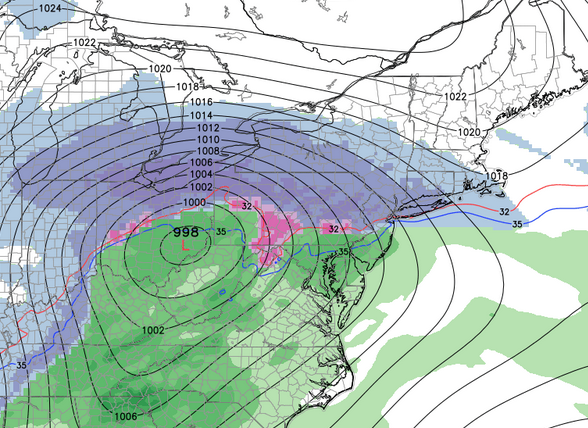
GFS wants a battle.  You can clearly see the 32 degree line with heavy snow to the north and rain to the south.  Notice there is very little mixing.  I feel this has to do with just how different these temperature variations are as warm air is pulled north.  In our area that line is cutting through southern Berks at the onset.  Of course this will change.


Here is the next image that clearly shows the low moving across the Mason Dixon line.  Everybody is now in the heavy rain portion of the storm with temperatures between 32 and 35.  The storm after this would track off the coast and once again give heavy snow to New England pulling down the cold air on the back end and finishing as snow for our region.


For the totals:


Berks:  3-5
Allentown:  6-10
Philadelphia: Coating-2


The Canadian model that tends to be similar to the GFS doesn't buy into the same idea.


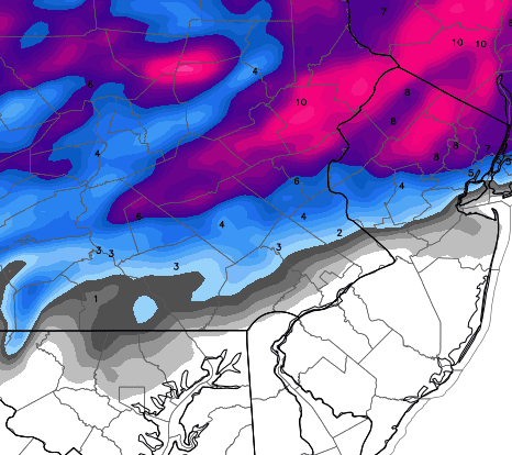
The Euro doesn't either.  Their snowfall maps look similar to the one above except scaled back a bit.  Totals for all of our region would fall in the 8-14 inch range.


Here is the current snow total map from NOAA.


AccuWeather is buying the GFS.


The Weather Channel is not.  Props for throwing in Allentown.  I better watch myself before I start falling for these guys again.


The North American short term was updating when I started this and have since adjusted totals a bit.  And they shifted to the south.


In a sense we have somewhat of a reversal from the last storm.  The Euro was the only major model to hang on to a significant snowfall in the interior while the GFS called for the push east.  This time the GFS is the only one to push this storm to the north while others keep cold air hanging further south.  It would be an easy decision if other outlets did not agree with the GFS, but it is clear AccuWeather shows some agreement.

Here is what we do know.  In almost anyway you slice it we are too close to the boundary between heavy snow and light snow to fully understand what will happen.  In a case of another change from the last storm where NOAA had totals I completely disagreed with I think their current map above is very accurate for right now.  I do think the GFS is too far north with the rain line however I don't think we can stay all snow right now.  The heaviest is just to our north running across the PA-NY border through CT and MA.

Since this will probably be the last time I post all these maps even though I'm sure there will be adjustments, I will use this as a basis going forward.  Which means I need to throw my hat in the ring.

Reading:  6.9 (They won't report)
Allentown: 8.6
Easton/Town close by:  9.4
House on top of 1,000 foot mountain in NJ:  12+

I am looking forward to this one regardless of totals.  Got to keep those snow totals climbing.

Currently after the random squalls yesterday:

Allentown = 19.1 inches   

Read more...

Dowery Follow-Up

>> Friday, January 30, 2015

There is an interesting scale that was created by a couple dudes from the National Weather Service that places storms in a certain category based off snowfall totals and population affected.  The only one I know of is designed for the northeast most likely because of the intensity of the storms and the amount of people in the region.  I've talked about this ranking before.  You can read more about it and all the guidelines if you care at NESIS.

I bring this up because I brought up yesterday that as much as I wanted to ride with the hype over the last storm it just didn't have what it takes to be considered one of those classic storms.  Well the guys at NESIS have already placed the storm into the rankings.  With that said you at least know it made the chart which dates back to storms from the late 1950's.  There are only 55 storms that have been placed in a category as of right now.

Here is the category and value system.  Again if you want details you have to read into it.


It sort of plays out in the same manner as a tornado or hurricane scale.

So where did this mighty storm that dropped three feet of snow in some areas fall on the list?


A big old 2.  Or in other words of the 54 storms already on the list this one fell into 41st. 

In case you are wondering only two have been classified as a category 5.  One was in January of 1996.  The other was the monster March 1993 storm.

Now that we can all calm down let's move on to the next system arriving Sunday night. 


Read more...

  © Blogger template Webnolia by Ourblogtemplates.com 2009

Back to TOP